
Where is Ozark Located? - Ozark is a city located in the Christian County of Missouri, United States. Ozark lies between 42.9375932 Degrees North latitudes and 70.8389219 Degrees West longitudes.
Location Map of Ozark, Missouri
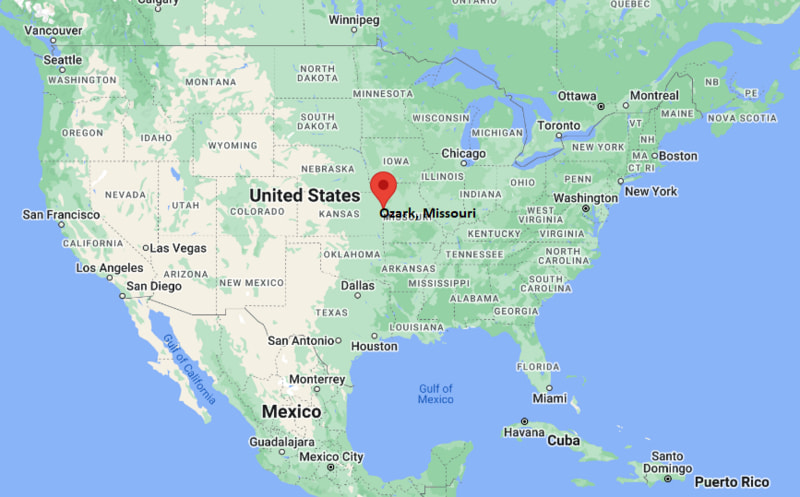
Ozark Map, Missouri, USA
Where is Ozark?: The Google Map showing the location of Ozark in the U.S. state of Missouri.
Where is Ozark Located?
Ozark is a city located in the Christian County of Missouri, United States. Ozark lies between 42.9375932 Degrees North latitudes and 70.8389219 Degrees West longitudes. According to 2020 U.S.census, the population of Ozark city is 21284 people and the city has a total area of 11.2 sq mi. The city has numerous parks and recreational facilities.
Most Viewed US Maps
| USA Sttae Map | USA Region Map | USA Road Map |
| USA County Map | Where is USA in World Map? | US ZIP Code Map |
| USA Time Zones Map | US State and Capitals Map | USA Physical Map |
Find 4,400+ U.S. Cities by State - Explore Their Locations and Get Detailed Information
Ozark, Missouri Quick Facts
| Attribute | Information |
|---|---|
| City | Ozark |
| County | Christian County |
| State | Missouri |
| State Capital | Jefferson City |
| US Region | Midwest (West North Central) |
| Latitude | 37.0209° N |
| Longitude | 93.2060° W |
| Elevation | 1,181 ft (360 m) |
| Land Area | 11.36 sq mi |
| Water Area | 0.03 sq mi |
| Total Area | 11.39 sq mi |
| Population (2020 Census) | 21,284 |
| Population Density | Approximately 1,874 per sq mi |
| ZIP Codes | 65721 |
| Area Code | 417 |
| Time Zone Standard | Central Standard Time (CST, UTC−6) |
| Time Zone Daylight | Central Daylight Time (CDT, UTC−5) |
| Currency | United States Dollar (USD) |
| FIPS Code | 29-55364 |
| Congressional District | Missouri's 7th Congressional District |
Transportation and Connectivity in Ozark
| Category | Information |
|---|---|
| Airport Name | Springfield-Branson National Airport |
| IATA Code | SGF |
| Nearest Regional Airport | Springfield-Branson National Airport |
| Major Highways | U.S. Route 65, Missouri Route 14, Missouri Route 744 |
| Rail Service | Freight rail service available in the Springfield region |
| Public Transit | City Utilities Transit service nearby in Springfield |
| Regional Connections | Springfield, Branson, and southwest Missouri access |
- Ozark is a city located in Christian County, Missouri, south of Springfield.
- The city was incorporated in 1890 and serves as the county seat of Christian County.
- Ozark developed as an agricultural community and later grew as a suburban center within the Springfield metropolitan area.
- The city is known for its natural surroundings, historic downtown, parks, and access to the Ozarks region.
Top Places to Visit in Ozark, Missouri
| Landmark Name | Type |
|---|---|
| Smallin Civil War Cave | Historic Cave Attraction |
| Finley River Park | Community Park and Recreation Area |
| Historic Downtown Ozark Square | Historic District |
| Stained Glass Theatre | Cultural and Performing Arts Venue |
| Busiek State Forest and Wildlife Area | Forest and Outdoor Recreation Area |
| James River | River and Recreation Area |
| Ozark Community Center | Recreation Facility |
| Christian County Museum | Local History Museum |
| Lake Springfield | Lake and Outdoor Recreation Area |
| Wilson's Creek National Battlefield | Historic Battlefield |
Driving Distances from Ozark, Missouri to Nearby Cities
| City | State | Distance (mi) | Approx. Drive Time |
|---|---|---|---|
| Springfield | Missouri | 12 | 20 minutes |
| Branson | Missouri | 35 | 45 minutes |
| Joplin | Missouri | 85 | 1 hour 20 minutes |
| Lebanon | Missouri | 70 | 1 hour |
| Rolla | Missouri | 110 | 1 hour 45 minutes |
| Fayetteville | Arkansas | 95 | 1 hour 40 minutes |
| Tulsa | Oklahoma | 180 | 2 hours 45 minutes |
| Kansas City | Missouri | 170 | 2 hours 40 minutes |
| St. Louis | Missouri | 215 | 3 hours 15 minutes |
| Memphis | Tennessee | 250 | 4 hours |
Colleges and Universities Near Ozark, Missouri
| Institution Name | Type | Level | Notable For |
|---|---|---|---|
| Ozarks Technical Community College | Public | Community College | Technical education, workforce training, healthcare, and career programs |
| Missouri State University | Public | University | Business, education, research, and liberal arts |
| Drury University | Private | University | Liberal arts, architecture, business, and sciences |
| Evangel University | Private | University | Christian higher education, arts, business, and education |
| College of the Ozarks | Private | College | Liberal arts, agriculture, and work-study education |
Waterbodies Near Ozark, Missouri
Finley River, James River, Lake Springfield, Table Rock Lake, and nearby waterways of Christian County.
Stadiums and Sports Facilities Near Ozark
Ozark High School athletic facilities, Ozark Community Center, Springfield-area sports venues, and regional recreation complexes.
Ozark, Missouri — Key Historical Facts
- Ozark was settled in the early nineteenth century and became the county seat of Christian County in 1859.
- The city was named after the surrounding Ozark Mountains region.
- Ozark developed around agriculture, trade routes, and the Finley River community.
- The arrival of improved transportation routes helped connect Ozark with Springfield and surrounding communities.
- The city experienced rapid suburban growth as part of the Springfield metropolitan area.
- Today, Ozark is recognized for its historic downtown, outdoor recreation, schools, and growing residential community.
Golf Courses Near Ozark, Missouri
| Golf Course Name | Type | Location |
|---|---|---|
| Rivercut Golf Course | Public Golf Course | Springfield, Missouri |
| Millwood Golf and Racquet Club | Private Golf Course | Ozark, Missouri |
| Fremont Hills Country Club | Private Golf Course | Nixa, Missouri |
| Hickory Hills Country Club | Private Golf Course | Springfield, Missouri |
| Buffalo Ridge Golf Course | Public Golf Course | Hollister, Missouri |
References
- City of Ozark, Missouri
- Christian County Government
- U.S. Census Bureau
- Missouri Tourism
- Missouri Department of Conservation
Other Missouri Maps & Info
- Where is Affton
- Where is Arnold
- Where is Ballwin
- Where is Belton
- Where is Blue Springs
- Where is Cape Girardeau
- Where is Chesterfield
- Where is Clayton
- Where is Columbia
- Where is Concord
- Where is Creve Coeur
- Where is Farmington
- Where is Ferguson
- Where is Florissant
- Where is Gladstone
- Where is Grandview
- Where is Hazelwood
- Where is Independence
- Where is Jefferson City
- Where is Joplin
- Where is Kirksville
- Where is Kirkwood
- Where is Lake St. Louis
- Where is Lee's Summit
- Where is Liberty
- Where is Manchester
- Where is Maryland Heights
- Where is Mehlville
- Where is Nixa
- Where is O'Fallon
- Where is Oakville
- Where is Old Jamestown
- Where is Ozark
- Where is Raymore
- Where is Raytown
- Where is Republic
- Where is Rolla
- Where is Sedalia
- Where is Spanish Lake
- Where is St. Charles
- Where is St. Joseph
- Where is St. Louis
- Where is St. Peters
- Where is University City
- Where is Warrensburg
- Where is Webster Groves
- Where is Wentzville
- Where is Wildwood