
Where is Sedalia Located? - Sedalia is a city located in the Pettis County of Missouri, United States. Sedalia lies between 42.8353619 Degrees North latitudes and 71.6489836 Degrees West longitudes.
Location Map of Sedalia, Missouri
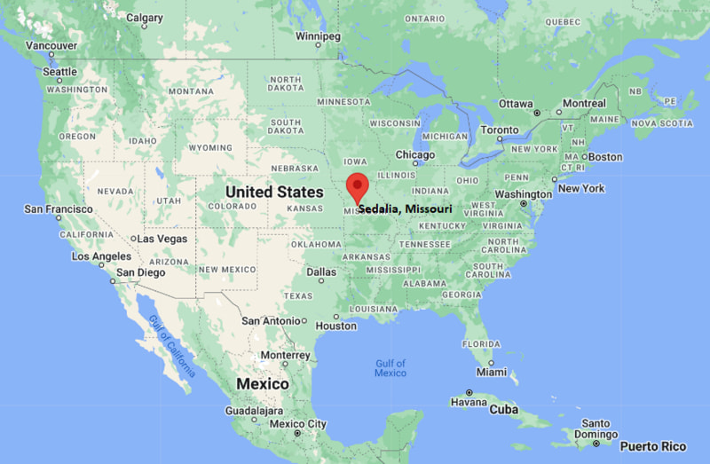
Sedalia Map, Missouri, USA
Where is Sedalia?: The Google Map showing the location of Sedalia in the U.S. state of Missouri.
Where is Sedalia Located?
Sedalia is a city located in the Pettis County of Missouri, United States. Sedalia lies between 42.8353619 Degrees North latitudes and 71.6489836 Degrees West longitudes. According to 2020 U.S.census, the population of Sedalia city is 21725 people and the city has a total area of 13.48 sq mi. The city has numerous parks and recreational facilities.
Most Viewed US Maps
| USA Sttae Map | USA Region Map | USA Road Map |
| USA County Map | Where is USA in World Map? | US ZIP Code Map |
| USA Time Zones Map | US State and Capitals Map | USA Physical Map |
Find 4,400+ U.S. Cities by State - Explore Their Locations and Get Detailed Information
Sedalia, Missouri Quick Facts
| Attribute | Details |
|---|---|
| City | Sedalia |
| County | Pettis County |
| State | Missouri |
| State Capital | Jefferson City |
| US Region | Midwestern United States |
| Latitude | 38.7045° N |
| Longitude | 93.2283° W |
| Elevation | 909 ft (277 m) |
| Land Area (sq mi) | 13.99 |
| Water Area (sq mi) | 0.13 |
| Total Area (sq mi) | 14.12 |
| Population (2020 Census) | 21,725 |
| Population Density (per sq mi) | 1,553.0 |
| ZIP Codes | 65301 |
| Area Code | 660 |
| Time Zone Standard | Central Standard Time (CST), UTC−6 |
| Time Zone Daylight | Central Daylight Time (CDT), UTC−5 |
| Currency | United States Dollar (USD) |
| FIPS Code | 2967454 |
| Congressional District | 4th Congressional District |
Transportation and Connectivity in Sedalia
| Transportation Feature | Details |
|---|---|
| Airport Name | Sedalia Regional Airport; Kansas City International Airport is the nearest major commercial airport. |
| IATA Code | DMO |
| Port | None |
| Major Highways | U.S. Highway 65, U.S. Highway 50, Missouri Route 52, Missouri Route 765, and Missouri Route 123 |
| Train/Amtrak Service | Amtrak's Missouri River Runner serves Sedalia Station with connections between Kansas City and St. Louis. |
| Local Bus/Transit Service | OATS provides public transportation services in the Sedalia area, with local and regional connections. |
- U.S. Highway 65 runs north-south through Sedalia and connects the city with Marshall, Warrensburg, and communities toward Springfield.
- U.S. Highway 50 runs east-west through Sedalia and connects the city with Kansas City, Jefferson City, and other central Missouri communities.
- Missouri Route 52 provides an east-west connection through the region and links Sedalia with communities such as Windsor and Cole Camp.
- Missouri Route 765 provides a local connection through the Sedalia area and connects with surrounding county roads.
- Missouri Route 123 connects Sedalia with communities north of the city, including Hughesville and Whiteman Air Force Base.
Top Places to Visit in Sedalia, Missouri
| Landmark Name | Type |
|---|---|
| Missouri State Fairgrounds | Fairgrounds |
| Daum Museum of Contemporary Art | Museum |
| Vermont Park | Park |
| Liberty Park | Park |
| Bothwell Lodge State Historic Site | Historic Site |
| Historic Downtown Sedalia | Historic District |
| George R. Smith Park | Park |
| Convention Hall | Historic Landmark |
| State Fair Community College | College Campus |
| Heckart Performing Arts Center | Performing Arts Center |
Driving Distances from Sedalia, Missouri to Nearby Cities
| City | State | Distance (mi) | Approx. Drive Time |
|---|---|---|---|
| Warrensburg | Missouri | 19 | 20 min |
| Marshall | Missouri | 28 | 30 min |
| Clinton | Missouri | 34 | 40 min |
| Carrollton | Missouri | 45 | 50 min |
| Lexington | Missouri | 55 | 1 hr |
| Jefferson City | Missouri | 65 | 1 hr 5 min |
| Columbia | Missouri | 75 | 1 hr 15 min |
| Kansas City | Missouri | 85 | 1 hr 20 min |
| Independence | Missouri | 82 | 1 hr 20 min |
| St. Joseph | Missouri | 120 | 1 hr 50 min |
Colleges and Universities in Sedalia, Missouri
| Institution Name | Type | Level | Notable For |
|---|---|---|---|
| State Fair Community College | Public | Community College | Career and technical education |
| University of Central Missouri | Public | University | Business, education, and professional programs |
| Central Methodist University | Private | University | Liberal arts and professional studies |
| Missouri Valley College | Private | University | Liberal arts and undergraduate programs |
Waterbodies in Sedalia, Missouri
Flat Creek, Muddy Creek, Spring Fork Creek, Lamine River
Golf Courses in Sedalia, Missouri
Sedalia Country Club, Hidden Creek Golf Course, Elm Hills Public Golf Course
Key Landmarks and Places to Visit in Sedalia, Missouri
| Landmark Name | Type |
|---|---|
| Missouri State Fairgrounds | Fairgrounds |
| Daum Museum of Contemporary Art | Museum |
| Bothwell Lodge State Historic Site | Historic Site |
| Historic Downtown Sedalia | Historic District |
| Vermont Park | Park |
| Liberty Park | Park |
| George R. Smith Park | Park |
| Convention Hall | Historic Landmark |
| Heckart Performing Arts Center | Performing Arts Center |
| Katy Trail State Park | State Park and Trail |
Waterbodies in Sedalia, Missouri
Flat Creek, Muddy Creek, Spring Fork Creek, Lamine River
Golf Courses in Sedalia, Missouri
Sedalia Country Club, Hidden Creek Golf Course, Elm Hills Public Golf Course
Sedalia, Missouri — Key Historical Facts
- Sedalia was founded in 1857 by George R. Smith and became an important settlement in central Missouri.
- The arrival of the Missouri Pacific Railroad in the 1860s helped Sedalia grow into a major regional transportation and commercial center.
- Sedalia became closely associated with the development of the cattle, agricultural, and railroad industries in western and central Missouri.
- The Missouri State Fair has been held in Sedalia since 1901 and remains one of the city's best-known annual events.
- The Katy Trail follows the former Missouri-Kansas-Texas Railroad corridor near Sedalia and preserves part of the region's railroad heritage.
References
- City of Sedalia Official Website
- Pettis County Government
- U.S. Census Bureau
- Missouri State Fair
- Bothwell Lodge State Historic Site — Missouri State Parks
- State Fair Community College
Other Missouri Maps & Info
- Where is Affton
- Where is Arnold
- Where is Ballwin
- Where is Belton
- Where is Blue Springs
- Where is Cape Girardeau
- Where is Chesterfield
- Where is Clayton
- Where is Columbia
- Where is Concord
- Where is Creve Coeur
- Where is Farmington
- Where is Ferguson
- Where is Florissant
- Where is Gladstone
- Where is Grandview
- Where is Hazelwood
- Where is Independence
- Where is Jefferson City
- Where is Joplin
- Where is Kirksville
- Where is Kirkwood
- Where is Lake St. Louis
- Where is Lee's Summit
- Where is Liberty
- Where is Manchester
- Where is Maryland Heights
- Where is Mehlville
- Where is Nixa
- Where is O'Fallon
- Where is Oakville
- Where is Old Jamestown
- Where is Ozark
- Where is Raymore
- Where is Raytown
- Where is Republic
- Where is Rolla
- Where is Sedalia
- Where is Spanish Lake
- Where is St. Charles
- Where is St. Joseph
- Where is St. Louis
- Where is St. Peters
- Where is University City
- Where is Warrensburg
- Where is Webster Groves
- Where is Wentzville
- Where is Wildwood