
Where is Liberty Located? - Liberty is a city located in the Clay County of Missouri, United States. Liberty lies between 42.7653662 Degrees North latitudes and 71.467566 Degrees West longitudes.
Location Map of Liberty, Missouri
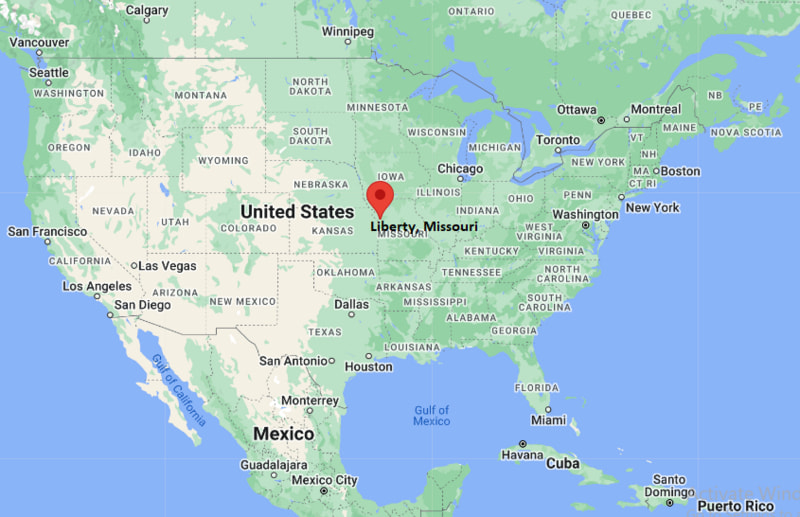
Liberty Map, Missouri, USA
Where is Liberty?: The Google Map showing the location of Liberty in the U.S. state of Missouri.
Where is Liberty Located?
Liberty is a city located in the Clay County of Missouri, United States. Liberty lies between 42.7653662 Degrees North latitudes and 71.467566 Degrees West longitudes. According to 2020 U.S.census, the population of Liberty city is 30167 people and the city has a total area of 28.83 sq mi. The city has numerous parks and recreational facilities.
Most Viewed US Maps
| USA Sttae Map | USA Region Map | USA Road Map |
| USA County Map | Where is USA in World Map? | US ZIP Code Map |
| USA Time Zones Map | US State and Capitals Map | USA Physical Map |
Find 4,400+ U.S. Cities by State - Explore Their Locations and Get Detailed Information
Liberty, Missouri Quick Facts
| Attribute | Details |
|---|---|
| City | Liberty |
| County | Clay County |
| State | Missouri |
| State Capital | Jefferson City |
| US Region | Midwestern United States |
| Latitude | 39.2461° N |
| Longitude | 94.4191° W |
| Elevation | 1,020 ft (311 m) |
| Land Area | 28.21 sq mi |
| Water Area | 0.17 sq mi |
| Total Area | 28.38 sq mi |
| Population (2020 Census) | 30,167 |
| Population Density | 1,069 per sq mi |
| ZIP Code(s) | 64068, 64069 |
| Area Code(s) | 816 |
| Time Zone Standard | Central Standard Time (CST, UTC−6) |
| Time Zone Daylight | Central Daylight Time (CDT, UTC−5) |
| Currency | United States Dollar (USD) |
| FIPS Code | 29-42716 |
| Congressional District | Missouri's 6th Congressional District |
Transportation and Connectivity in Liberty
| Category | Details |
|---|---|
| Airport Name | Kansas City International Airport |
| IATA Code | MCI |
| Port | No Commercial Port |
| Major Highways | Interstate 35, U.S. Route 69, Missouri Route 291, Missouri Route 210 |
| Train/Amtrak Service | Nearest Amtrak station in Kansas City |
| Local Bus/Transit Service | KCATA RideKC regional transit services |
- Interstate 35 provides direct north-south access between Liberty, Kansas City, and communities in northern Missouri.
- U.S. Route 69 and Missouri Route 291 connect Liberty with the Kansas City metropolitan area.
- Regional transit connections are available through RideKC services linking Liberty with nearby communities.
- Kansas City International Airport provides domestic and international air travel options approximately 25 miles west of Liberty.
Top Places to Visit in Liberty, Missouri
| Landmark Name | Type |
|---|---|
| Jesse James Bank Museum | Historic Museum |
| Clay County Historical Society Museum | History Museum |
| Historic Downtown Liberty | Historic District |
| William Jewell College Campus | Historic College Campus |
| Stocksdale Park | Community Park |
| Fountain Bluff Sports Complex | Sports Facility |
| Clay County Museum | Museum |
| Liberty Jail Historic Site | Historic Site |
| Shoal Creek Living History Museum | Living History Museum |
| Kansas City Zoo (nearby) | Zoo |
Driving Distances from Liberty, Missouri to Nearby Cities
| City | State | Distance (mi) | Approx. Drive Time |
|---|---|---|---|
| Kansas City | Missouri | 15 | 25 minutes |
| Independence | Missouri | 25 | 35 minutes |
| Gladstone | Missouri | 8 | 15 minutes |
| Excelsior Springs | Missouri | 18 | 25 minutes |
| St. Joseph | Missouri | 45 | 50 minutes |
| Lawrence | Kansas | 55 | 1 hour |
| Topeka | Kansas | 80 | 1 hour 25 minutes |
| Columbia | Missouri | 125 | 2 hours |
| St. Louis | Missouri | 245 | 3 hours 45 minutes |
| Omaha | Nebraska | 185 | 2 hours 45 minutes |
Colleges and Universities in Liberty, Missouri
| Institution Name | Type | Level | Notable For |
|---|---|---|---|
| William Jewell College | Private | Liberal Arts College | Liberal arts, sciences, business, and professional studies |
| Park University | Private | University | Online education, business, public administration, and liberal arts programs |
| Metropolitan Community College – Maple Woods | Public | Community College | Technical education, career training, and transfer programs |
| University of Missouri–Kansas City | Public | University | Research, medicine, business, engineering, and arts programs |
| Rockhurst University | Private | University | Business, healthcare, leadership, and liberal arts education |
Waterbodies in Liberty, Missouri
Liberty is located within the Fishing River and Shoal Creek watersheds and is surrounded by several streams, ponds, and reservoirs. Nearby water resources include Smithville Lake, Shoal Creek, Fishing River, and local park lakes. These waterways support recreation, fishing, wildlife habitat, stormwater management, and outdoor activities throughout Clay County.
Stadiums in Liberty
Liberty features several athletic facilities, including William Jewell College's Greene Stadium, Liberty High School's William Jewell Field, Liberty North High School athletic facilities, and Fountain Bluff Sports Complex. These venues host football, baseball, soccer, softball, track and field, and community sporting events.
Liberty, Missouri — Key Historical Facts
- Liberty was founded in 1822 and became the county seat of Clay County shortly afterward.
- The city was named "Liberty" because early settlers valued independence and self-government.
- Liberty is home to the Jesse James Bank Museum, site of the first successful daylight bank robbery by Jesse James in 1866.
- During the nineteenth century, Liberty became an important center for trade, government, and education in northwest Missouri.
- Today, Liberty is a growing suburban community in the Kansas City metropolitan area with historic landmarks, educational institutions, and modern residential development.
References
- City of Liberty
- Clay County Government
- U.S. Census Bureau
- William Jewell College
- Missouri State Parks
Other Missouri Maps & Info
- Where is Affton
- Where is Arnold
- Where is Ballwin
- Where is Belton
- Where is Blue Springs
- Where is Cape Girardeau
- Where is Chesterfield
- Where is Clayton
- Where is Columbia
- Where is Concord
- Where is Creve Coeur
- Where is Farmington
- Where is Ferguson
- Where is Florissant
- Where is Gladstone
- Where is Grandview
- Where is Hazelwood
- Where is Independence
- Where is Jefferson City
- Where is Joplin
- Where is Kirksville
- Where is Kirkwood
- Where is Lake St. Louis
- Where is Lee's Summit
- Where is Liberty
- Where is Manchester
- Where is Maryland Heights
- Where is Mehlville
- Where is Nixa
- Where is O'Fallon
- Where is Oakville
- Where is Old Jamestown
- Where is Ozark
- Where is Raymore
- Where is Raytown
- Where is Republic
- Where is Rolla
- Where is Sedalia
- Where is Spanish Lake
- Where is St. Charles
- Where is St. Joseph
- Where is St. Louis
- Where is St. Peters
- Where is University City
- Where is Warrensburg
- Where is Webster Groves
- Where is Wentzville
- Where is Wildwood