
Where is Belton Located? - Belton is a city located in the Cass County of Missouri, United States. Belton lies between 42.8651298 Degrees North latitudes and 71.3739272 Degrees West longitudes.
Location Map of Belton, Missouri
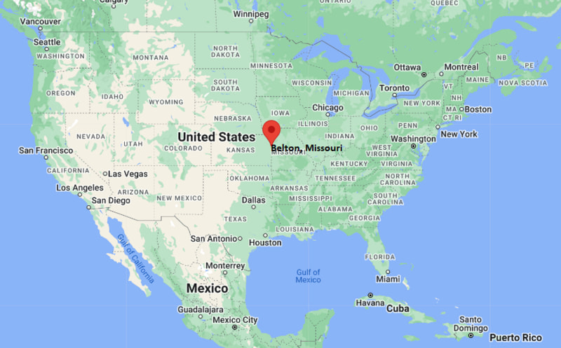
Belton Map, Missouri, USA
Where is Belton?: The Google Map showing the location of Belton in the U.S. state of Missouri.
Where is Belton Located?
Belton is a city located in the Cass County of Missouri, United States. Belton lies between 42.8651298 Degrees North latitudes and 71.3739272 Degrees West longitudes. According to 2020 U.S.census, the population of Belton city is 23953 people and the city has a total area of 14.14 sq mi. The city has numerous parks and recreational facilities.
Most Viewed US Maps
| USA Sttae Map | USA Region Map | USA Road Map |
| USA County Map | Where is USA in World Map? | US ZIP Code Map |
| USA Time Zones Map | US State and Capitals Map | USA Physical Map |
Find 4,400+ U.S. Cities by State - Explore Their Locations and Get Detailed Information
Belton, Missouri Quick Facts
| Fact | Details |
|---|---|
| City | Belton |
| County | Cass County |
| State | Missouri |
| State Capital | Jefferson City |
| Country | United States |
| US Region | Midwest |
| Latitude | 38.8119°N |
| Longitude | 94.5319°W |
| Elevation | 1,010 ft (308 m) |
| Land Area | 16.9 sq mi |
| Water Area | 0.2 sq mi |
| Total Area | 17.1 sq mi |
| Population (Census 2020) | 23,116 |
| Population Density | Approximately 1,368 per sq mi |
| ZIP Codes | 64012 |
| Area Code | 816 |
| Time Zone Standard | Central Standard Time (CST, UTC-6) |
| Time Zone Daylight | Central Daylight Time (CDT, UTC-5) |
| Currency | United States Dollar (USD) |
| FIPS Code | 29-04276 |
| Congressional District | Missouri's 4th Congressional District |
Nearby Cities to Belton, Missouri
- Raymore, Missouri - 3 mi East
- Grandview, Missouri - 8 mi North
- Peculiar, Missouri - 8 mi South
- Lee's Summit, Missouri - 16 mi Northeast
- Overland Park, Kansas - 17 mi West
- Kansas City, Missouri - 23 mi North
- Olathe, Kansas - 18 mi West
- Harrisonville, Missouri - 18 mi Southeast
- Lenexa, Kansas - 20 mi Northwest
- Independence, Missouri - 28 mi Northeast
Belton, Missouri Climate and Weather Overview
| Month | Avg High (°F) | Avg Low (°F) | Avg Rainfall (in) |
|---|---|---|---|
| January | 40 | 21 | 1.3 |
| April | 66 | 45 | 4.3 |
| July | 89 | 69 | 4.2 |
| October | 69 | 47 | 3.1 |
| Annual | 66 | 46 | 41.5 |
| Climate Attribute | Details |
|---|---|
| Climate Classification | Humid Continental (Köppen Dfa) |
| Annual Rainfall | Approximately 42 inches |
| Annual Sunshine Days | About 215 days |
| Hurricane/Tornado Risk | Moderate - Severe thunderstorms, tornadoes and winter storms |
| Snowfall | Approximately 15 inches annually |
Driving Distances from Belton, Missouri
| City | State | Distance (mi) | Approx. Drive Time |
|---|---|---|---|
| Raymore | Missouri | 3 | 7 min |
| Grandview | Missouri | 8 | 12 min |
| Peculiar | Missouri | 8 | 12 min |
| Lee's Summit | Missouri | 16 | 22 min |
| Overland Park | Kansas | 17 | 25 min |
| Olathe | Kansas | 18 | 25 min |
| Harrisonville | Missouri | 18 | 22 min |
| Lenexa | Kansas | 20 | 28 min |
| Kansas City | Missouri | 23 | 30 min |
| Independence | Missouri | 28 | 35 min |
Transportation and Connectivity in Belton, Missouri
| Transportation | Details |
|---|---|
| Airport Name | Kansas City International Airport |
| IATA Code | MCI |
| Port | Missouri River Port facilities (Kansas City region) |
| Major Highways | Interstate 49, U.S. Highway 71, Missouri Route 58, Missouri Route 150 |
| Train/Amtrak Service | Nearest Amtrak station at Kansas City Union Station |
| Local Bus/Transit Service | RideKC regional bus service (limited routes) |
- Interstate 49 - Primary north-south interstate connecting Belton with Kansas City and Joplin.
- U.S. Highway 71 - Regional highway providing convenient access to surrounding communities and southern Missouri.
- Missouri Route 58 - Main east-west route through Belton connecting Raymore, Grandview and local commercial areas.
- Missouri Route 150 - Connects Belton with Lee's Summit, Overland Park and the southern Kansas City metropolitan area.
Key Landmarks and Places to Visit in Belton, Missouri
| Landmark | Type |
|---|---|
| Belton Grandview and Kansas City Railroad | Heritage Railroad |
| Memorial Park | City Park |
| Cleveland Lake | Recreation Area |
| High Blue Wellness Center | Recreation Center |
| Belton Historical Society Museum | Museum |
| Cass County Northern Resource Center | Community Facility |
| Wallace Park | Community Park |
| Longview Lake | Regional Recreation Area |
| Harry S. Truman Farm Home | Historic Site |
| Powell Gardens | Botanical Garden |
Colleges and Universities in Belton, Missouri
| Institution | Type | Level | Notable For |
|---|---|---|---|
| Metropolitan Community College - Longview | Public | Community College | Transfer and workforce education |
| Avila University | Private | University | Business, nursing and education |
| University of Central Missouri - Lee's Summit | Public | University | Graduate and professional programs |
| University of Missouri-Kansas City | Public | University | Research and health sciences |
| Rockhurst University | Private | University | Liberal arts and business |
| Johnson County Community College | Public | Community College | Career and technical education |
Waterbodies in Belton, Missouri
Cleveland Lake, Longview Lake, Blue River, Big Creek, Little Blue River, Missouri River, Lake Jacomo, Prairie Lee Lake, Smithville Lake, James A. Reed Memorial Wildlife Area Lakes.
Golf Courses in Belton, Missouri
Eagle Glen Golf Club, Creekmoor Golf Club, Fred Arbanas Golf Course, Heritage Park Golf Course, Shamrock Hills Golf Club, WinterStone Golf Course, Hillcrest Golf & Country Club, Swope Memorial Golf Course.
Belton, Missouri - Key Historical Facts
- Belton was established in 1871 following the arrival of the railroad, which encouraged trade and settlement in Cass County.
- The city became an important agricultural shipping center for livestock, grain and other farm products during the late nineteenth century.
- Its location along major transportation corridors supported continued commercial and residential growth throughout the twentieth century.
- The Belton Grandview and Kansas City Railroad preserves part of the area's railroad heritage through scenic excursion train rides.
- Belton has grown as part of the Kansas City metropolitan area while maintaining its historic downtown and community-focused atmosphere.
- Today, the city is known for its family-friendly neighborhoods, parks, local businesses and convenient access to employment centers throughout the Kansas City region.
References
Other Missouri Maps & Info
- Where is Affton
- Where is Arnold
- Where is Ballwin
- Where is Belton
- Where is Blue Springs
- Where is Cape Girardeau
- Where is Chesterfield
- Where is Clayton
- Where is Columbia
- Where is Concord
- Where is Creve Coeur
- Where is Farmington
- Where is Ferguson
- Where is Florissant
- Where is Gladstone
- Where is Grandview
- Where is Hazelwood
- Where is Independence
- Where is Jefferson City
- Where is Joplin
- Where is Kirksville
- Where is Kirkwood
- Where is Lake St. Louis
- Where is Lee's Summit
- Where is Liberty
- Where is Manchester
- Where is Maryland Heights
- Where is Mehlville
- Where is Nixa
- Where is O'Fallon
- Where is Oakville
- Where is Old Jamestown
- Where is Ozark
- Where is Raymore
- Where is Raytown
- Where is Republic
- Where is Rolla
- Where is Sedalia
- Where is Spanish Lake
- Where is St. Charles
- Where is St. Joseph
- Where is St. Louis
- Where is St. Peters
- Where is University City
- Where is Warrensburg
- Where is Webster Groves
- Where is Wentzville
- Where is Wildwood