
Where is Florissant Located? - Florissant is a city located in the St. Louis County of Missouri, United States. Florissant lies between 38.5246441 Degrees North latitudes and 118.624578 Degrees West longitudes.
Location Map of Florissant, Missouri
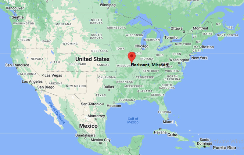
Florissant Map, Missouri, USA
Where is Florissant?: The Google Map showing the location of Florissant in the U.S. state of Missouri.
Where is Florissant Located?
Florissant is a city located in the St. Louis County of Missouri, United States. Florissant lies between 38.5246441 Degrees North latitudes and 118.624578 Degrees West longitudes. According to 2020 U.S.census, the population of Florissant city is 52533 people and the city has a total area of 12.55 sq mi. The city has numerous parks and recreational facilities.
Most Viewed US Maps
| USA Sttae Map | USA Region Map | USA Road Map |
| USA County Map | Where is USA in World Map? | US ZIP Code Map |
| USA Time Zones Map | US State and Capitals Map | USA Physical Map |
Find 4,400+ U.S. Cities by State - Explore Their Locations and Get Detailed Information
Florissant, Missouri Quick Facts
| Property | Information |
|---|---|
| City | Florissant |
| County | St. Louis County |
| State | Missouri |
| State Capital | Jefferson City |
| US Region | Midwestern United States |
| Latitude | 38.7892° N |
| Longitude | 90.3226° W |
| Elevation | 551 ft (168 m) |
| Land Area | 12.87 sq mi |
| Water Area | 0.02 sq mi |
| Total Area | 12.89 sq mi |
| Population (latest Census year) | 52,533 (2020 Census) |
| Population Density | 4,082 per sq mi |
| ZIP Codes | 63031, 63032, 63033, 63034 |
| Area Code | 314 |
| Time Zone Standard | Central Standard Time (CST, UTC−6) |
| Time Zone Daylight | Central Daylight Time (CDT, UTC−5) |
| Currency | US Dollar (USD) |
| FIPS Code | 29-24742 |
| Congressional District | 1st Congressional District |
Nearby Cities to Florissant, Missouri
- Hazelwood, Missouri — 4 mi Southwest
- Black Jack, Missouri — 4 mi North
- Dellwood, Missouri — 5 mi Southeast
- Bridgeton, Missouri — 6 mi West
- Ferguson, Missouri — 6 mi South
- Maryland Heights, Missouri — 9 mi Southwest
- Spanish Lake, Missouri — 8 mi East
- Overland, Missouri — 10 mi South
- St. Charles, Missouri — 13 mi West
- St. Louis, Missouri — 17 mi Southeast
Driving Distances from Florissant, Missouri
| City | State | Distance (mi) | Approx. Drive Time |
|---|---|---|---|
| Hazelwood | Missouri | 4 | 10 min |
| Black Jack | Missouri | 4 | 10 min |
| Dellwood | Missouri | 5 | 12 min |
| Bridgeton | Missouri | 6 | 15 min |
| Ferguson | Missouri | 6 | 15 min |
| Maryland Heights | Missouri | 9 | 18 min |
| St. Charles | Missouri | 13 | 22 min |
| St. Louis | Missouri | 17 | 30 min |
| Chesterfield | Missouri | 24 | 35 min |
| Belleville | Illinois | 35 | 45 min |
Transportation and Connectivity in Florissant, Missouri
| Category | Information |
|---|---|
| Airport Name | St. Louis Lambert International Airport |
| IATA Code | STL |
| Port | Port of St. Louis (regional inland port) |
| Major Highways | Interstate 270, U.S. Route 67 (Lindbergh Boulevard), Missouri Route N, Missouri Route 367 |
| Train/Amtrak Service | Nearest Amtrak station is St. Louis Gateway Station |
| Local Bus/Transit Service | Metro Transit St. Louis (MetroBus) |
- Interstate 270 - Outer beltway providing access to St. Louis, Illinois, and western St. Louis County.
- U.S. Route 67 (Lindbergh Boulevard) - Primary north-south route connecting Florissant with downtown St. Louis and north St. Louis County.
- Missouri Route N (New Halls Ferry Road) - Important local roadway serving residential and commercial neighborhoods.
- Missouri Route 367 - Connects Florissant with Interstate 270, Interstate 70 and communities along the Mississippi River.
What are top Places to Visit in Florissant, Missouri
| Landmark Name | Type |
|---|---|
| Old St. Ferdinand Shrine | Historic Site |
| St. Ferdinand Park | City Park |
| James J. Eagan Center | Recreation Center |
| Bangert Park | Community Park |
| Florissant Valley Park | Nature Park |
| St. Louis County Library – Florissant Valley Branch | Library |
| Coldwater Creek Greenway | Trail |
| Boeing Prologue Room | Aviation Museum |
| Missouri Civil War Museum | Museum |
| Gateway Arch National Park | National Park |
Colleges and Universities in Florissant, Missouri
| Institution Name | Type | Level | Notable For |
|---|---|---|---|
| St. Louis Community College – Florissant Valley | Public | Community College | Transfer, career and technical education |
| University of Missouri–St. Louis | Public | University | Research, business and education programs |
| Washington University in St. Louis | Private | University | Research and medical education |
| Ferguson-Florissant School District | Public | K–12 District | Comprehensive public education |
Waterbodies in Florissant, Missouri
Missouri River, Mississippi River, Coldwater Creek, Maline Creek, Spanish Lake, Creve Coeur Lake, Dardenne Creek, Bellefontaine Lake
Golf Courses in Florissant, Missouri
Normandie Golf Club, Eagle Springs Golf Course, Ruth Park Golf Course, Florissant Golf Club, Gateway National Golf Links, Forest Park Golf Course
Florissant, Missouri — Key Historical Facts
- Florissant was founded in the late eighteenth century as the French settlement of Fleurissant and is one of the oldest communities in Missouri.
- The town developed under French and later Spanish colonial rule before becoming part of the United States through the Louisiana Purchase in 1803.
- Historic Old St. Ferdinand Shrine, established in the early 1800s, remains one of the oldest Catholic parishes west of the Mississippi River.
- Following World War II, Florissant experienced rapid suburban growth as the St. Louis metropolitan area expanded northward.
- Today, Florissant is the largest municipality in St. Louis County, known for its historic district, parks, educational institutions, and strong residential community.
References
Other Missouri Maps & Info
- Where is Affton
- Where is Arnold
- Where is Ballwin
- Where is Belton
- Where is Blue Springs
- Where is Cape Girardeau
- Where is Chesterfield
- Where is Clayton
- Where is Columbia
- Where is Concord
- Where is Creve Coeur
- Where is Farmington
- Where is Ferguson
- Where is Florissant
- Where is Gladstone
- Where is Grandview
- Where is Hazelwood
- Where is Independence
- Where is Jefferson City
- Where is Joplin
- Where is Kirksville
- Where is Kirkwood
- Where is Lake St. Louis
- Where is Lee's Summit
- Where is Liberty
- Where is Manchester
- Where is Maryland Heights
- Where is Mehlville
- Where is Nixa
- Where is O'Fallon
- Where is Oakville
- Where is Old Jamestown
- Where is Ozark
- Where is Raymore
- Where is Raytown
- Where is Republic
- Where is Rolla
- Where is Sedalia
- Where is Spanish Lake
- Where is St. Charles
- Where is St. Joseph
- Where is St. Louis
- Where is St. Peters
- Where is University City
- Where is Warrensburg
- Where is Webster Groves
- Where is Wentzville
- Where is Wildwood