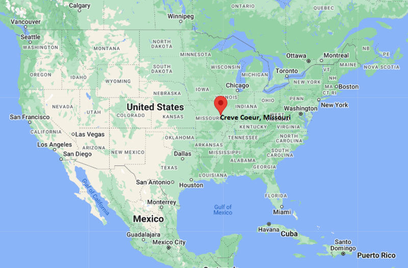
Where is Creve Coeur Located? - Creve Coeur is a city located in the St. Louis County of Missouri, United States. Creve Coeur lies between 43.0967213 Degrees North latitudes and 71.4651283 Degrees West longitudes.
Location Map of Creve Coeur, Missouri
Creve Coeur Map, Missouri, USA
Where is Creve Coeur Located?
Creve Coeur is a city located in the St. Louis County of Missouri, United States. Creve Coeur lies between 43.0967213 Degrees North latitudes and 71.4651283 Degrees West longitudes. According to 2020 U.S.census, the population of Creve Coeur city is 18834 people and the city has a total area of 10.28 sq mi. The city has numerous parks and recreational facilities.
Most Viewed US Maps
Creve Coeur, Missouri Quick Facts
Field Value
City Creve Coeur County St. Louis County State Missouri State Capital Jefferson City US Region Midwestern United States Latitude 38.6609°N Longitude 90.4226°W Elevation 535 ft (163 m) Land Area 10.4 sq mi Water Area 0.3 sq mi Total Area 10.7 sq mi Population ~18,000 (2020 Census) Population Density ~1,700 per sq mi ZIP Codes 63141, 63146 Area Code 314, 636 Time Zone (Standard) Central Standard Time (CST) UTC -6 Time Zone (DST) Central Daylight Time (CDT) UTC -5 Currency US Dollar (USD) FIPS Code 29-17074 Congressional District 2nd District
Nearby Cities to Creve Coeur, Missouri
St. Louis, Missouri — 15 mi East
Chesterfield, Missouri — 8 mi West
Clayton, Missouri — 7 mi Southeast
Brentwood, Missouri — 10 mi Southeast
University City, Missouri — 8 mi East
Maryland Heights, Missouri — 6 mi North
Ballwin, Missouri — 10 mi West
O’Fallon, Missouri — 25 mi West
St. Charles, Missouri — 15 mi Northwest
Fenton, Missouri — 12 mi South
Creve Coeur, Missouri Climate and Weather Overview
Month Avg High (°F) Avg Low (°F) Avg Rainfall (in)
January 39 23 2.3 April 66 45 3.9 July 89 70 4.1 October 68 48 2.8 Annual 66 47 40.5
Climate Attribute Value
Climate Classification (Köppen) Humid Continental (Dfa) Annual Rainfall ~38–42 inches Annual Snowfall ~15–20 inches Annual Sunshine Days ~200 days Tornado Risk Moderate
Driving Distances from Creve Coeur, Missouri
City State Distance (mi) Approx. Drive Time
St. Louis MO 15 20 min Chesterfield MO 8 15 min Clayton MO 7 15 min Maryland Heights MO 6 10 min Ballwin MO 10 15 min St. Charles MO 15 20 min Brentwood MO 10 15 min Fenton MO 12 20 min O’Fallon MO 25 30 min Columbia MO 125 2 hr
Transportation and Connectivity in Creve Coeur, Missouri
Mode Details
Airport St. Louis Lambert International Airport (STL) Port Mississippi River Port of St. Louis (regional access) Major Highways I-270, US-40 (Page Ave), MO-340 Rail/Amtrak Amtrak service available in St. Louis Local Transit MetroBus and MetroLink (St. Louis region transit system)
I-270 — major outer belt highway connecting Creve Coeur to St. Louis suburbs
US-40 (Page Avenue) — key east-west corridor linking to downtown St. Louis
MO-340 — local arterial route connecting Creve Coeur with Chesterfield area
Key Landmarks and Places to Visit in Creve Coeur, Missouri
Landmark Name Type
Creve Coeur Lake Memorial Park State Park / Recreation Missouri Botanical Garden (nearby) Botanical Garden St. Louis Art Museum (nearby) Museum World Bird Sanctuary (nearby) Wildlife Sanctuary Creve Coeur Park Lake Lake Recreation Area Hollywood Casino Amphitheatre (nearby) Entertainment Venue St. Louis Zoo (nearby) Zoo Des Peres Park (nearby) City Park
Places to Visit in Creve Coeur, Missouri
Landmark Name Type
Creve Coeur Lake Scenic Trail Nature Trail Downtown St. Louis Riverfront (nearby) Tourist Area Forest Park (nearby) Urban Park Westport Plaza Entertainment District St. Louis Science Center (nearby) Museum Magic House (nearby Kirkwood) Children’s Museum Top Golf St. Louis (nearby) Recreation Venue Chesterfield Valley (nearby) Shopping & Dining Area
Colleges and Universities in Creve Coeur, Missouri
Institution Name Type Level Notable For
Washington University in St. Louis (nearby) Private University Research & medicine University of Missouri–St. Louis (nearby) Public University Urban research programs Saint Louis Community College (Meramec Campus) Public Community College Career training & transfer programs
Waterbodies in Creve Coeur, Missouri
Creve Coeur Lake, Missouri River (regional), Mississippi River (regional), Fee Fee Creek, Dardenne Creek
Golf Courses in Creve Coeur, Missouri
Westwood Country Club, Creve Coeur Golf Course, Missouri Bluffs Golf Club (nearby), Bellerive Country Club (nearby)
Creve Coeur, Missouri - Key Historical Facts
The area was originally settled in the early 19th century as part of expanding communities around St. Louis.
The name “Creve Coeur” comes from French meaning “broken heart,” linked to a local legend and the lake shape.
Creve Coeur Lake was once the largest natural lake in Missouri and a popular recreation spot for generations.
The city developed rapidly after World War II as suburban growth spread across St. Louis County.
Major medical and research institutions nearby influenced the city’s modern residential and business development.
Today it is known for parks, healthcare access, and its strong connection to the greater St. Louis metro area.
References
Other Missouri Maps & Info
Location Map of Missouri Cities
Popular US Cities
About USA
US Counties
World Countries
World Cup 2026