
Washington is a city in eastern Missouri on the Missouri River, about 50 miles west of St. Louis. Located in Franklin County, the city is known for its historic riverfront, downtown architecture, German heritage, and access to nearby wineries and outdoor areas. Washington combines a long history as a river community with its role as a regional center in east-central Missouri.
Location Map of Washington, Franklin County, Missouri
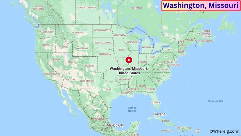
About Map: The map shows the location of Washington in Franklin County, in the U.S. state of Missouri.
Washington Map, Missouri
About Washington Map: The Google Map highlights the location of Washington in Franklin County, Missouri. Use the zoom, satellite, and street-view options to explore the city's neighborhoods, roads, and nearby places.
Where is Washington Located?
Washington is a city located in Franklin County, Missouri, the United States. It sits along the southern bank of the Missouri River, about 50 miles west of St. Louis and 25 miles south of Warrenton. Washington lies at approximately 38.558° North latitude and 91.013° West longitude. The city had 13,982 residents in the 2020 Census and covers about 10.39 square miles, or 26.91 square kilometers. Washington was founded in 1831 and grew around river transportation, agriculture, manufacturing, and trade. Its historic downtown includes buildings that reflect the city's German-American heritage and its development as a Missouri River port. The river remains an important geographic feature, while nearby rolling farmland and wooded hills shape the surrounding landscape. Washington is also close to the Katy Trail State Park and several wineries in the Missouri Rhineland region. U.S. Route 40, Missouri Route 47, and Missouri Route 100 provide connections to St. Louis, Union, Warrenton, and other communities across eastern Missouri.
Most Viewed US Maps
| USA Sttae Map | USA Region Map | USA Road Map |
| USA County Map | Where is USA in World Map? | US ZIP Code Map |
| USA Time Zones Map | US State and Capitals Map | USA Physical Map |
Find 4,400+ U.S. Cities by State - Explore Their Locations and Get Detailed Information
Washington City Facts
| Fact | Details |
|---|---|
| City | Washington |
| State | Missouri |
| County | Franklin County |
| Country | United States |
| Region | Eastern Missouri / Missouri River Valley |
| Incorporated | 1839 |
| Founded | 1831 |
| Total Area | 10.39 sq mi (26.91 sq km) |
| Land Area | 10.36 sq mi (26.83 sq km) |
| Water Area | 0.03 sq mi (0.08 sq km) |
| Elevation | Approximately 520 ft (158 m) |
| Population (2023 estimate) | Approximately 14,500 |
| Population (2020 Census) | 13,982 |
| Population Density | Approximately 1,350 people per sq mi |
| Time Zone | Central Time Zone (CST/CDT) |
| ZIP Codes | 63090 |
| Area Code | 636 |
| Major Highways | U.S. Route 40, Missouri Route 47, Missouri Route 100 |
| Public Transit | Washington and Franklin County regional transportation services |
| Major Attractions | Historic Downtown Washington, Missouri River, Washington Historical Society, Katy Trail State Park |
| Official Website | https://washmo.gov/ |
Distance from Washington, MO to Nearby Cities
- Union, MO – 8 miles (13 km)
- New Haven, MO – 10 miles (16 km)
- Pacific, MO – 15 miles (24 km)
- St. Clair, MO – 18 miles (29 km)
- Warrenton, MO – 25 miles (40 km)
- Hermann, MO – 25 miles (40 km)
- Fenton, MO – 35 miles (56 km)
- O'Fallon, MO – 38 miles (61 km)
- St. Peters, MO – 35 miles (56 km)
- Chesterfield, MO – 35 miles (56 km)
- St. Charles, MO – 40 miles (64 km)
- Florissant, MO – 50 miles (80 km)
- St. Louis, MO – 50 miles (80 km)
- Jefferson City, MO – 75 miles (121 km)
- Columbia, MO – 85 miles (137 km)
- Quincy, IL – 125 miles (201 km)
- Springfield, MO – 190 miles (306 km)
- Kansas City, MO – 225 miles (362 km)
Top Attractions in Washington
- Historic Downtown Washington – The downtown district features historic commercial buildings, local shops, restaurants, and architecture shaped by the city's Missouri River and German heritage.
- Washington Riverfront – The Missouri River waterfront provides scenic views, walking areas, parks, and access to the city's historic river setting.
- Washington Historical Society Museum – A local museum preserving artifacts, photographs, documents, and stories from Washington and Franklin County.
- Missouri River – The river is a defining geographic feature of Washington and supports boating, fishing, wildlife viewing, and scenic recreation.
- Washington City Park – A local recreation area offering walking paths, open green space, playgrounds, sports facilities, and community amenities.
- James W. Rennick Riverfront Park – A riverfront park providing open space, walking areas, and views of the Missouri River.
- Katy Trail State Park – A major Missouri trail near Washington that follows the former Missouri-Kansas-Texas Railroad corridor and is popular for hiking and cycling.
- St. John's United Church of Christ – A historic downtown church reflecting the German-American heritage and architecture of Washington.
- Missouri Rhineland Wineries – Several wineries near Washington are part of the historic Missouri Rhineland and offer views across the region's rolling countryside.
- Daniel Boone Home – A nearby historic site in Defiance preserving the home associated with Daniel Boone and the early settlement of the Missouri River region.
Airports Near Washington, MO
- Washington Regional Airport (FYG) – 7 miles
- Spirit of St. Louis Airport (SUS) – 30 miles
- St. Louis Lambert International Airport (STL) – 55 miles
- Columbia Regional Airport (COU) – 85 miles
- Quincy Regional Airport (UIN) – 125 miles
Sources:
Population and area data sourced from the United States Census Bureau (2020 Census). General city information referenced from the official City of Washington website and local government records.
Other Missouri Maps & Info
- Where is Affton
- Where is Arnold
- Where is Ballwin
- Where is Belton
- Where is Blue Springs
- Where is Cape Girardeau
- Where is Chesterfield
- Where is Clayton
- Where is Columbia
- Where is Concord
- Where is Creve Coeur
- Where is Farmington
- Where is Ferguson
- Where is Florissant
- Where is Gladstone
- Where is Grandview
- Where is Hazelwood
- Where is Independence
- Where is Jefferson City
- Where is Joplin
- Where is Kirksville
- Where is Kirkwood
- Where is Lake St. Louis
- Where is Lee's Summit
- Where is Liberty
- Where is Manchester
- Where is Maryland Heights
- Where is Mehlville
- Where is Nixa
- Where is O'Fallon
- Where is Oakville
- Where is Old Jamestown
- Where is Ozark
- Where is Raymore
- Where is Raytown
- Where is Republic
- Where is Rolla
- Where is Sedalia
- Where is Spanish Lake
- Where is St. Charles
- Where is St. Joseph
- Where is St. Louis
- Where is St. Peters
- Where is University City
- Where is Warrensburg
- Where is Webster Groves
- Where is Wentzville
- Where is Wildwood