
West Plains is a city in southern Missouri and the county seat of Howell County. It is about 100 miles east of Springfield and 25 miles north of the Arkansas state line. Set in the Ozark foothills, West Plains is a regional center for education, healthcare, farming, and trade. The city also provides access to nearby forests, springs, lakes, and scenic Ozark landscapes.
Location Map of West Plains, Howell County, Missouri
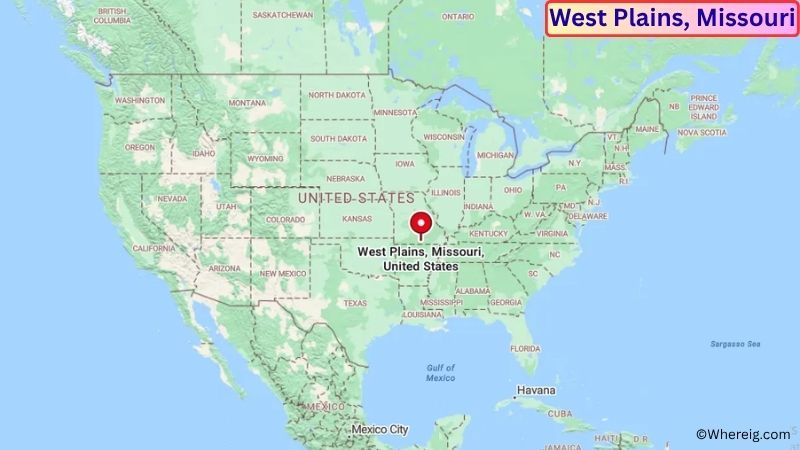
About Map: The map shows the location of West Plains in Howell County, in the U.S. state of Missouri.
West Plains Map, Missouri
About West Plains Map: The Google Map highlights the location of West Plains in Howell County, Missouri. Use the zoom, satellite, and street-view options to explore the city's neighborhoods, roads, and nearby places.
Where is West Plains Located?
West Plains is a city located in Howell County, Missouri, the United States. It is in south-central Missouri in the Ozark Mountains, about 100 miles east of Springfield, 25 miles north of the Arkansas state line, and approximately 70 miles west of Poplar Bluff. West Plains lies at approximately 36.728° North latitude and 91.852° West longitude. The city had 11,986 residents in the 2020 Census and covers about 13.96 square miles, or 36.16 square kilometers. West Plains was settled in the 1840s and became the county seat of Howell County. Its location on the Ozark Plateau helped it develop as a center for farming, timber, commerce, and transportation. The city is also home to Missouri State University-West Plains, a regional two-year campus that serves students from the surrounding area. Nearby outdoor attractions include the Mark Twain National Forest, North Fork River, and Alley Spring. The Ozark National Scenic Riverways are also within driving distance. U.S. Route 63 and U.S. Route 160 are the main highways serving West Plains and connect the city with communities throughout southern Missouri and northern Arkansas.
Most Viewed US Maps
| USA Sttae Map | USA Region Map | USA Road Map |
| USA County Map | Where is USA in World Map? | US ZIP Code Map |
| USA Time Zones Map | US State and Capitals Map | USA Physical Map |
Find 4,400+ U.S. Cities by State - Explore Their Locations and Get Detailed Information
West Plains City Facts
| Fact | Details |
|---|---|
| City | West Plains |
| State | Missouri |
| County | Howell County |
| Country | United States |
| Region | South-Central Missouri / Ozarks |
| Incorporated | 1883 |
| Founded | 1840s |
| Total Area | 13.96 sq mi (36.16 sq km) |
| Land Area | 13.92 sq mi (36.05 sq km) |
| Water Area | 0.04 sq mi (0.10 sq km) |
| Elevation | Approximately 1,050 ft (320 m) |
| Population (2023 estimate) | Approximately 12,000 |
| Population (2020 Census) | 11,986 |
| Population Density | Approximately 861 people per sq mi |
| Time Zone | Central Time Zone (CST/CDT) |
| ZIP Codes | 65775 |
| Area Code | 417 |
| Major Highways | U.S. Route 63, U.S. Route 160, Missouri Route 14 |
| Public Transit | Howell Valley Transportation services |
| Major Attractions | Harlin Museum, Mark Twain National Forest, North Fork River, Missouri State University-West Plains |
| Official Website | https://www.westplains.gov/ |
Distance from West Plains, MO to Nearby Cities
- Willow Springs, MO – 15 miles (24 km)
- Pomona, MO – 10 miles (16 km)
- Mountain View, MO – 25 miles (40 km)
- Thayer, MO – 25 miles (40 km)
- Alton, MO – 35 miles (56 km)
- Gainesville, MO – 35 miles (56 km)
- Houston, MO – 45 miles (72 km)
- Cabool, MO – 45 miles (72 km)
- Winona, MO – 45 miles (72 km)
- Salem, MO – 65 miles (105 km)
- Poplar Bluff, MO – 70 miles (113 km)
- Springfield, MO – 100 miles (161 km)
- Rolla, MO – 100 miles (161 km)
- Lebanon, MO – 90 miles (145 km)
- Branson, MO – 95 miles (153 km)
- Mountain Home, AR – 45 miles (72 km)
- Jonesboro, AR – 115 miles (185 km)
- Little Rock, AR – 180 miles (290 km)
Top Attractions in West Plains
- Harlin Museum – A local museum housed in a historic building and featuring art, regional history, cultural exhibits, and community programs.
- West Plains Civic Center – A community facility hosting concerts, performances, events, sports activities, and local gatherings.
- Missouri State University-West Plains – A regional college campus that serves students from southern Missouri and surrounding Ozark communities.
- Mark Twain National Forest – A large forested area surrounding much of southern Missouri, offering hiking, camping, fishing, hunting, horseback riding, and scenic drives.
- North Fork River – A scenic Ozark river known for clear water, fishing, canoeing, kayaking, and wildlife viewing.
- Alley Spring Mill – A historic red mill near Eminence set beside a large spring and surrounded by the Ozark landscape.
- Ozark National Scenic Riverways – A major protected area along the Current and Jacks Fork rivers, known for springs, caves, forests, canoeing, and hiking.
- Grand Gulf State Park – A nearby geological site featuring a collapsed cave system and dramatic limestone walls.
- Rockbridge Rainbow Trout & Game Ranch – A nearby outdoor destination featuring trout fishing, streams, and scenic Ozark surroundings.
- Big Spring State Park – A major spring and recreation destination farther east near Van Buren, known for its clear spring water and Ozark scenery.
Airports Near West Plains, MO
- West Plains Regional Airport (KUNO) – 5 miles
- Mountain Home Ozark County Airport (BPK) – 45 miles
- Springfield-Branson National Airport (SGF) – 105 miles
- Waynesville-St. Robert Regional Airport (TBN) – 105 miles
- Branson Airport (BKG) – 110 miles
Sources:
Population and area data sourced from the United States Census Bureau (2020 Census). General city information referenced from the official City of West Plains website and local government records.
Other Missouri Maps & Info
- Where is Affton
- Where is Arnold
- Where is Ballwin
- Where is Belton
- Where is Blue Springs
- Where is Cape Girardeau
- Where is Chesterfield
- Where is Clayton
- Where is Columbia
- Where is Concord
- Where is Creve Coeur
- Where is Farmington
- Where is Ferguson
- Where is Florissant
- Where is Gladstone
- Where is Grandview
- Where is Hazelwood
- Where is Independence
- Where is Jefferson City
- Where is Joplin
- Where is Kirksville
- Where is Kirkwood
- Where is Lake St. Louis
- Where is Lee's Summit
- Where is Liberty
- Where is Manchester
- Where is Maryland Heights
- Where is Mehlville
- Where is Nixa
- Where is O'Fallon
- Where is Oakville
- Where is Old Jamestown
- Where is Ozark
- Where is Raymore
- Where is Raytown
- Where is Republic
- Where is Rolla
- Where is Sedalia
- Where is Spanish Lake
- Where is St. Charles
- Where is St. Joseph
- Where is St. Louis
- Where is St. Peters
- Where is University City
- Where is Warrensburg
- Where is Webster Groves
- Where is Wentzville
- Where is Wildwood