
Aspen is a city in the Rocky Mountains of west-central Colorado and serves as the county seat of Pitkin County. It is part of the Glenwood Springs metropolitan area and is located about 160 miles west of Denver. The city is known for its world-famous ski resorts, luxury mountain scenery, and year-round outdoor recreation.
Location Map of Aspen, Pitkin County, Colorado
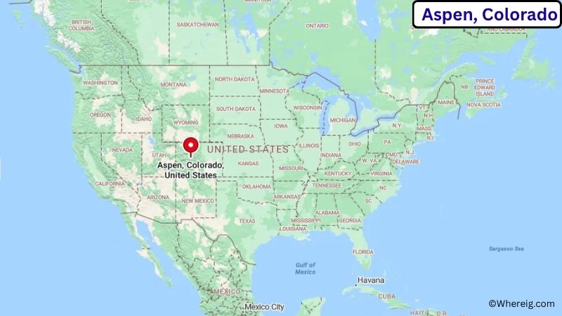
About Map: The map shows the location of Aspen in Pitkin County, in the U.S. state of Colorado.
Aspen Map, Colorado
About Aspen Map: The Google Map highlights the location of Aspen in Pitkin County, Colorado. Use the zoom, satellite, and street-view options to explore the city's neighborhoods, roads, and nearby places.
Where is Aspen Located?
Aspen is a city located in Pitkin County, Colorado, the United States. The city sits high in the Elk Mountains along the Roaring Fork River in central Colorado. It is approximately 40 miles (64 km) southeast of Glenwood Springs, 108 miles (174 km) southwest of Vail, and about 160 miles (257 km) west of Denver. Aspen is located at 39.1911° North latitude and 106.8175° West longitude. According to the 2020 United States Census, the city had a population of 7,004. Aspen covers approximately 3.66 square miles (9.48 sq km). The city is internationally known for Aspen Mountain, Aspen Snowmass, world-class skiing, and major cultural events such as the Aspen Music Festival and School.
Most Viewed US Maps
| USA Sttae Map | USA Region Map | USA Road Map |
| USA County Map | Where is USA in World Map? | US ZIP Code Map |
| USA Time Zones Map | US State and Capitals Map | USA Physical Map |
Find 4,400+ U.S. Cities by State - Explore Their Locations and Get Detailed Information
Aspen City Facts
| City | Aspen |
| State | Colorado |
| County | Pitkin County |
| Country | United States |
| Region | Rocky Mountains |
| Incorporated | 1881 |
| Founded | 1879 |
| Total Area | 3.66 sq mi (9.48 sq km) |
| Land Area | 3.64 sq mi (9.43 sq km) |
| Water Area | 0.02 sq mi (0.05 sq km) |
| Elevation | 7,908 ft (2,410 m) |
| Population (2023 estimate) | Approximately 6,900 |
| Population (2020 Census) | 7,004 |
| Population Density | About 1,925 people per sq mi |
| Time Zone | Mountain Time (MT) (UTC−7/UTC−6) |
| ZIP Codes | 81611, 81612 |
| Area Code | 970 |
| Major Highways | Colorado State Highway 82 |
| Public Transit | Roaring Fork Transportation Authority (RFTA) |
| Major Attractions | Aspen Mountain, Aspen Snowmass, Maroon Bells, John Denver Sanctuary, Aspen Art Museum |
| Official Website | https://www.aspen.gov/ |
Distance from Aspen, CO to Nearby Cities
- Snowmass Village, CO – 9 miles (14 km)
- Basalt, CO – 20 miles (32 km)
- Carbondale, CO – 31 miles (50 km)
- Glenwood Springs, CO – 40 miles (64 km)
- New Castle, CO – 53 miles (85 km)
- Rifle, CO – 66 miles (106 km)
- Eagle, CO – 71 miles (114 km)
- Vail, CO – 108 miles (174 km)
- Leadville, CO – 58 miles (93 km)
- Buena Vista, CO – 82 miles (132 km)
- Montrose, CO – 128 miles (206 km)
- Grand Junction, CO – 125 miles (201 km)
- Breckenridge, CO – 95 miles (153 km)
- Steamboat Springs, CO – 170 miles (274 km)
- Colorado Springs, CO – 180 miles (290 km)
- Denver, CO – 160 miles (257 km)
- Durango, CO – 205 miles (330 km)
- Telluride, CO – 146 miles (235 km)
- Salida, CO – 112 miles (180 km)
- Craig, CO – 173 miles (278 km)
Top Attractions in Aspen
- Aspen Mountain
- Maroon Bells
- Aspen Snowmass
- John Denver Sanctuary
- Aspen Art Museum
- Independence Pass
- Aspen Highlands
- Buttermilk Ski Area
- Rio Grande Trail
- Wheeler Opera House
Airports Near Aspen
- Aspen/Pitkin County Airport (ASE) – 4 miles (6 km)
- Eagle County Regional Airport (EGE) – 68 miles (109 km)
- Gunnison–Crested Butte Regional Airport (GUC) – 81 miles (130 km)
- Grand Junction Regional Airport (GJT) – 125 miles (201 km)
- Denver International Airport (DEN) – 220 miles (354 km)
Sources:
Population and area data sourced from the United States Census Bureau (2020 Census). General city information referenced from the Official City of Aspen Website.
Colorado Maps and Info
- Where is Arvada
- Where is Black Forest
- Where is Boulder
- Where is Brighton
- Where is Broomfield
- Where is Castle Rock
- Where is Centennial
- Where is Cimarron Hills
- Where is Clifton
- Where is Columbine
- Where is Commerce City
- Where is Dakota Ridge
- Where is Durango
- Where is Englewood
- Where is Erie
- Where is Evans
- Where is Firestone
- Where is Fort Carson
- Where is Fort Collins
- Where is Fountain
- Where is Frederick
- Where is Golden
- Where is Grand Junction
- Where is Greeley
- Where is Greenwood Village
- Where is Highlands Ranch
- Where is Johnstown
- Where is Ken Caryl
- Where is Lafayette
- Where is Lakewood
- Where is Littleton
- Where is Lone Tree
- Where is Longmont
- Where is Loveland
- Where is Montrose
- Where is Northglenn
- Where is Parker
- Where is Pueblo
- Where is Pueblo West
- Where is Security-Widefield
- Where is Sherrelwood
- Where is Thornton
- Where is Welby
- Where is Westminster
- Where is Wheat Ridge
- Where is Windsor