Written and Fact-checked by Whereig Editors, Reviewed by Mukesh Kumar| Last Updated On: May 11, 2026
Map of Queen Anne's County - Queen Anne's County is a county located in the U.S. state of Maryland. Queen Anne's County Map showing cities, highways, important places and water bodies. Get Where is Queen Anne's County located in the map, major cities in Queen Anne's county, population, areas, and places of interest.
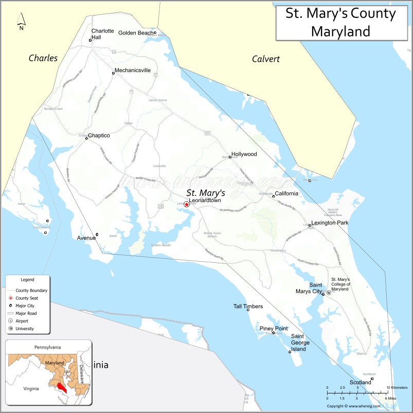
Map of St Mary's County, Maryland
About Queen Anne's County Map, Alabama: The map showing the county boundary, county seat, major cities, highways, water bodies and neighbouring counties.
More Maryland Maps & Info
Map of St Mary's County, Maryland
St. Mary's County is a county located in the U.S. state of Maryland. It's county seat is Leonardtown. As per 2020 census, the population of St. Mary's County is 114468 people and population density is square miles. According to the United States Census Bureau, the county has a total area of 611 sq mi (1,582 km2). St. Mary's County was established on 1637.
St Mary's County Facts
| Continent | North America |
| Country | United States |
| State | Maryland |
| County Seat | Leonardtown |
| Largest City/Town | California |
| Established | 1637 |
| Total Area | 764 sq mi (1,979 sq km) |
| Land Area | 357 sq mi (925 sq km) |
| Water Area | 407 sq mi (1,054 sq km) |
| Population | 113,777 (Census 2020) |
| Population Density | 318.7 people per sq mi |
| Time Zone | Eastern Time Zone (ET) |
| Major Highways | Maryland Route 5, Maryland Route 235, Maryland Route 4, Maryland Route 246 |
| Major Rivers | Potomac River, Patuxent River, St. Mary’s River |
| Neighboring Counties | Charles County, Calvert County, King George County (Virginia) |
| Famous For | Colonial history, Chesapeake Bay waterfronts, naval aviation, seafood, historic St. Mary’s City |
| Top Attractions | Historic St. Mary’s City, Patuxent River Naval Air Museum, Point Lookout State Park, Solomons nearby, Chesapeake Bay recreation |
| Official Website | Official Website |
About St Mary's County, Maryland
St Mary's County is located in southern Maryland in the United States along the Chesapeake Bay and was established in 1637 as one of Maryland’s oldest counties. The county seat is Leonardtown, while California is the largest community. The county is known for colonial heritage, waterfront recreation, naval aviation industries, seafood culture, and scenic Chesapeake Bay landscapes.
Cities and Communities in St Mary's County, Maryland
| City/Community | Population (Census 2020) | Latitude & Longitude |
|---|---|---|
| Leonardtown (county seat) | 4,563 | 38.2918°N, 76.6358°W |
| California | 14,973 | 38.3004°N, 76.5075°W |
| Lexington Park | 13,317 | 38.2668°N, 76.4527°W |
| Charlotte Hall | 1,420 | 38.4837°N, 76.7866°W |
| Mechanicsville | 1,816 | 38.4429°N, 76.7441°W |
| Hollywood | 1,119 | 38.3443°N, 76.5772°W |
| Ridge | 1,148 | 38.1134°N, 76.3849°W |
| Piney Point | 966 | 38.1390°N, 76.5272°W |
| Great Mills | 5,500+ | 38.2351°N, 76.4950°W |
| St. Inigoes | 1,500+ | 38.1637°N, 76.4230°W |
Golf Courses in St Mary's County, Maryland
| Golf Course | Location | Latitude & Longitude |
|---|---|---|
| Wicomico Shores Golf Course | Mechanicsville | 38.4095°N, 76.7138°W |
| Breton Bay Golf & Country Club | Leonardtown | 38.2795°N, 76.6204°W |
| Cedar Point Golf Course | Patuxent River NAS | 38.2890°N, 76.4093°W |
Roads and Highways in St Mary's County
Major highways connect the county with southern Maryland, Washington metropolitan areas, and Chesapeake Bay communities.
- Maryland Route 5 - primary north-south highway through St. Mary’s County
- Maryland Route 235 - major commuter and commercial route serving Lexington Park and California
- Maryland Route 4 - regional route connecting southern Maryland with Annapolis and Washington areas
- Maryland Route 246 - roadway serving historic St. Mary’s City and waterfront communities
- Maryland Route 249 - scenic route toward Point Lookout and Chesapeake Bay areas
Neighboring Counties of St Mary's County
- Charles County (northwest)
- Calvert County (north across the Patuxent River)
- King George County, Virginia (southwest across the Potomac River)
Top Attractions in St Mary's County, Maryland
The county offers colonial landmarks, waterfront recreation, museums, and Chesapeake Bay attractions.
- Historic St. Mary’s City - reconstructed colonial settlement and Maryland’s first capital
- Patuxent River Naval Air Museum - exhibits on naval aviation and aerospace history
- Point Lookout State Park - beaches, camping, fishing, Civil War history, and Chesapeake Bay scenery
- Solomons nearby - waterfront village with marinas, museums, and seafood restaurants
- St. Clement’s Island Museum - exhibits on Maryland colonial history and early settlers
- Piney Point Lighthouse Museum - historic lighthouse and maritime heritage site
- Chesapeake Bay Boating Areas - marinas, fishing charters, and waterfront recreation
- Leonardtown Historic District - shops, restaurants, galleries, and local events
- St. Mary’s River State Park - hiking, fishing, and kayaking opportunities
- Seafood Restaurants and Crab Houses - local Maryland blue crabs, oysters, and Chesapeake cuisine
Distance from St Mary's County to Nearby Cities
The following distances are measured by road (driving).
- Leonardtown to Washington, D.C. - 71 mi (114 km)
- Leonardtown to Annapolis (Anne Arundel County), Maryland - 77 mi (124 km)
- Leonardtown to Baltimore (Baltimore City), Maryland - 92 mi (148 km)
- Leonardtown to Richmond (Richmond City), Virginia - 92 mi (148 km)
- Leonardtown to Norfolk (Norfolk City), Virginia - 165 mi (266 km)
- Leonardtown to Ocean City (Worcester County), Maryland - 146 mi (235 km)
- Leonardtown to Philadelphia (Philadelphia County), Pennsylvania - 188 mi (303 km)
- Leonardtown to New York City (New York County), New York - 282 mi (454 km)
- Leonardtown to Pittsburgh (Allegheny County), Pennsylvania - 319 mi (513 km)
- Leonardtown to Charlotte (Mecklenburg County), North Carolina - 353 mi (568 km)
- Leonardtown to Boston (Suffolk County), Massachusetts - 494 mi (795 km)
- Leonardtown to Cleveland (Cuyahoga County), Ohio - 466 mi (750 km)
FAQs about St Mary's County
St Mary's County is located in southern Maryland along the Chesapeake Bay.
St Mary's County has a population of 113,777 according to the Census 2020.
The county is known for colonial history, naval aviation, seafood, and Chesapeake Bay waterfronts.
Major highways include Maryland Route 5, Maryland Route 235, Maryland Route 4, and Maryland Route 246.
Yes, St Mary's County has golf facilities including Wicomico Shores Golf Course and Breton Bay Golf & Country Club.
References
- QuickFacts - U.S. Census Bureau
- United States Census Bureau
- United States Geological Survey (USGS)
- National Geodetic Survey
- Official Website
- Allegany County Map
- Anne Arundel County Map
- Baltimore County Map
- Calvert County Map
- Caroline County Map
- Carroll County Map
- Cecil County Map
- Charles County Map
- Dorchester County Map
- Frederick County Map
- Garrett County Map
- Harford County Map
- Howard County Map
- Kent County Map
- Montgomery County Map
- Prince George's County Map
- Queen Anne's County Map
- St Mary's County Map
- Somerset County Map
- Talbot County Map
- Washington County Map
- Wicomico County Map
- Worcester County Map
- Baltimore City County Map
- Alabama Counties
- Alaska boroughs
- Arizona Counties
- Arkansas Counties
- California County Map
- Colorado Counties
- Connecticut Counties
- Delaware Counties
- Florida County Map
- Georgia County Map
- Hawaii Counties
- Idaho Counties
- Illinois Counties
- Indiana Counties
- Iowa Counties
- Kansas Counties
- Kentucky Counties
- Louisiana Counties
- Maine Counties
- Maryland Counties
- Massachusetts Counties
- Michigan County Map
- Minnesota Counties
- Mississippi Counties
- Missouri Counties
- Montana Counties
- Nebraska Counties
- Nevada Counties
- New York Counties
- New Hampshire Counties
- New Jersey Counties
- New Mexico Counties
- North Carolina Counties
- North Dakota Counties
- Ohio County Map
- Oklahoma Counties
- Oregon Counties
- Pennsylvania Counties
- Rhode Island Counties
- South Carolina Counties
- South Dakota Counties
- Map of Tennessee
- Texas County Map
- Utah Counties
- Vermont Counties
- Virginia Counties
- Washington Counties
- West Virginia Counties
- Wisconsin Counties
- Wyoming Counties