Map of Columbia County - Columbia County is a county located in the U.S. state of Wisconsin. Columbia County Map showing cities, highways, important places and water bodies. Get Where is Columbia County located in the map, major cities in Columbia county, population, areas, and places of interest.
Map of Columbia County, Wisconsin
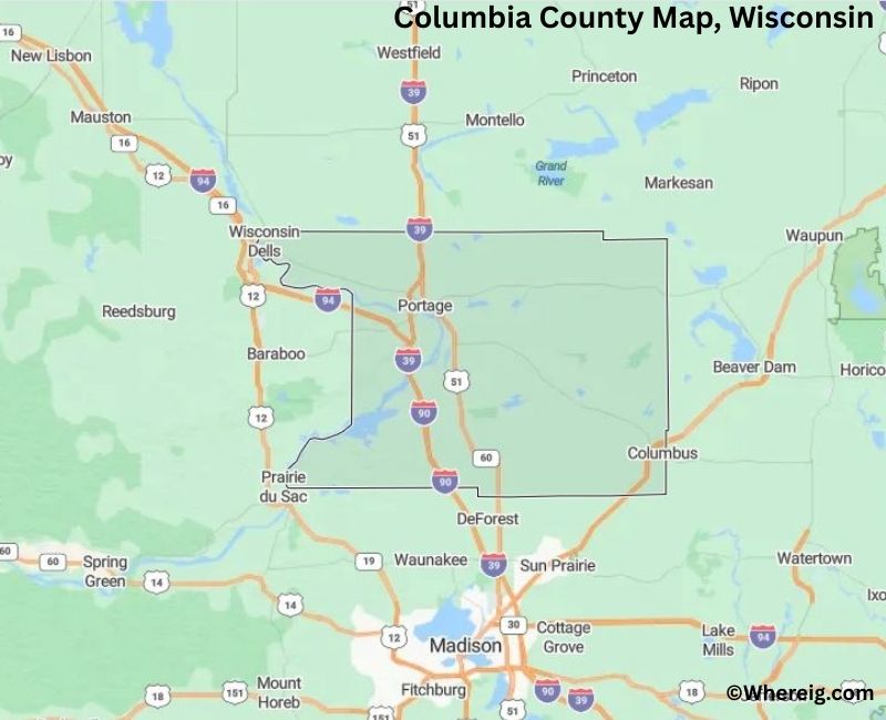
About Columbia County Map, Alabama: The map showing the county boundary, county seat, major cities, highways, water bodies and neighbouring counties.
Most Viewed Links
Map of Columbia County, Wisconsin
Facts about Columbia County, Wisconsin
| Country | United States |
| State | Wisconsin |
| Region | South-Central Wisconsin |
| County Seat | Portage |
| Named After | Christopher Columbus |
| Established | 1846 |
| Organized | 1846 |
| Coordinates | 43.47° N, 89.33° W |
| Total Area | ~783 sq mi |
| Land Area | ~766 sq mi |
| Water Area | ~17 sq mi |
| Population (2020) | 58,490 |
| Population Rank | Mid-sized county in Wisconsin |
| Largest City | Portage |
| Main Industries | Agriculture, Manufacturing, Healthcare, Education |
| Major Highways | Interstate 39, Interstate 90, Interstate 94, U.S. Highway 51 |
| Time Zone | Central Time (UTC−06:00) |
| Known For | Wisconsin River, agriculture, transportation corridors |
| Official Website | https://www.co.columbia.wi.us |
Top Attractions in Columbia County, Wisconsin
- Columbia County Courthouse – Historic courthouse.
- Columbus Historic District – Downtown historic area.
- Lake Wisconsin – Boating and fishing lake.
- Governor Nelson State Park – Trails and lake access.
- Columbia County Fairgrounds – Annual fair and events.
- Portage Canal and Riverwalk – Scenic walking path.
- Wild Rose State Wildlife Area – Wildlife viewing.
- Columbus City Park – Community park and recreation.
- Local Covered Bridges – Historic rural bridges.
- Columbia County Historical Society Museum – Local history exhibits.
List of Cities and Towns in Columbia County, Wisconsin
Portage, Columbus, Lodi, Poynette, Fall River, Cambria, Arlington, Wisconsin Dells (portion), Caledonia, Dekorra, Fountain Prairie, Hampden, Leeds, Lodi (Town), Lewiston, Marcellon, Merrimac, Otsego, Randolph, Rio, Scott, Springvale, West Point, Wyocena
Map of Wisconsin Counties
- Adams County Map, WI
- Ashland County Map, WI
- Barron County Map, WI
- Bayfield County Map, WI
- Brown County Map, WI
- Buffalo County Map, WI
- Burnett County Map, WI
- Calumet County Map, WI
- Chippewa County Map, WI
- Clark County Map, WI
- Columbia County Map, WI
- Crawford County Map, WI
- Dane County Map, WI
- Dodge County Map, WI
- Door County Map, WI
- Douglas County Map, WI
- Dunn County Map, WI
- Eau Claire County Map, WI
- Florence County Map, WI
- Fond Du Lac County Map, WI
- Forest County Map, WI
- Grant County Map, WI
- Green County Map, WI
- Green Lake County Map, WI
- Iowa County Map, WI
- Iron County Map, WI
- Jackson County Map, WI
- Jefferson County Map, WI
- Juneau County Map, WI
- Kenosha County Map, WI
- Kewaunee County Map, WI
- La Crosse County Map, WI
- Lafayette County Map, WI
- Langlade County Map, WI
- Lincoln County Map, WI
- Manitowoc County Map, WI
- Marathon County Map, WI
- Marinette County Map, WI
- Marquette County Map, WI
- Menominee County Map, WI
- Milwaukee County Map, WI
- Monroe County Map, WI
- Oconto County Map, WI
- Oneida County Map, WI
- Outagamie County Map, WI
- Ozaukee County Map, WI
- Pepin County Map, WI
- Pierce County Map, WI
- Polk County Map, WI
- Portage County Map, WI
- Price County Map, WI
- Racine County Map, WI
- Richland County Map, WI
- Rock County Map, WI
- Rusk County Map, WI
- Sauk County Map, WI
- Sawyer County Map, WI
- Shawano County Map, WI
- Sheboygan County Map, WI
- St Croix County Map, WI
- Taylor County Map, WI
- Trempealeau County Map, WI
- Vernon County Map, WI
- Vilas County Map, WI
- Walworth County Map, WI
- Washburn County Map, WI
- Washington County Map, WI
- Waukesha County Map, WI
- Waupaca County Map, WI
- Waushara County Map, WI
- Winnebago County Map, WI
- Wood County Map, WI
US Counties Map by State
- Alabama Counties
- Alaska boroughs
- Arizona Counties
- Arkansas Counties
- California County Map
- Colorado Counties
- Connecticut Counties
- Delaware Counties
- Florida County Map
- Georgia County Map
- Hawaii Counties
- Idaho Counties
- Illinois Counties
- Indiana Counties
- Iowa Counties
- Kansas Counties
- Kentucky Counties
- Louisiana Counties
- Maine Counties
- Maryland Counties
- Massachusetts Counties
- Michigan County Map
- Minnesota Counties
- Mississippi Counties
- Missouri Counties
- Montana Counties
- Nebraska Counties
- Nevada Counties
- New York Counties
- New Hampshire Counties
- New Jersey Counties
- New Mexico Counties
- North Carolina Counties
- North Dakota Counties
- Ohio County Map
- Oklahoma Counties
- Oregon Counties
- Pennsylvania Counties
- Rhode Island Counties
- South Carolina Counties
- South Dakota Counties
- Map of Tennessee
- Texas County Map
- Utah Counties
- Vermont Counties
- Virginia Counties
- Washington Counties
- West Virginia Counties
- Wisconsin Counties
- Wyoming Counties