Map of Dane County - Dane County is a county located in the U.S. state of Wisconsin. Dane County Map showing cities, highways, important places and water bodies. Get Where is Dane County located in the map, major cities in Dane county, population, areas, and places of interest.
Map of Dane County, Wisconsin
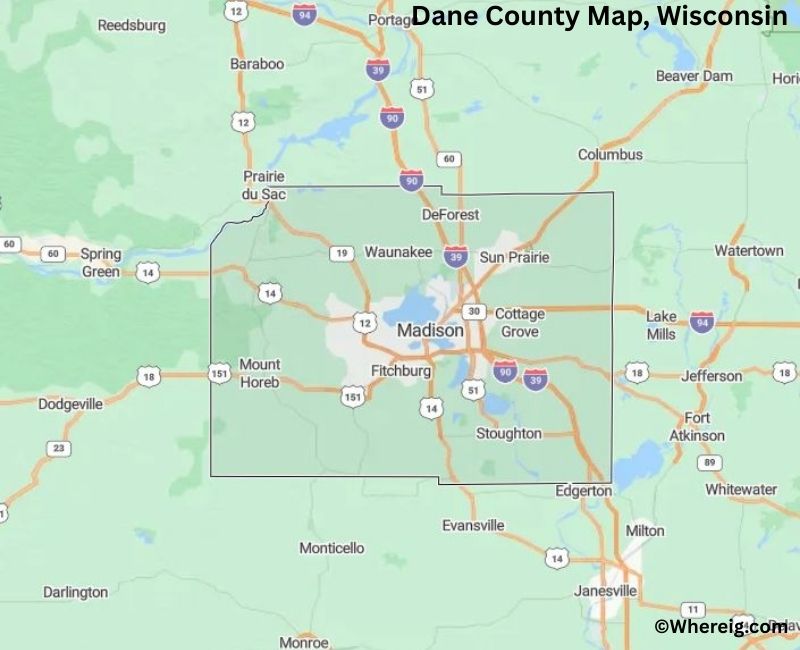
About Dane County Map, Alabama: The map showing the county boundary, county seat, major cities, highways, water bodies and neighbouring counties.
Most Viewed Links
Map of Dane County, Wisconsin
Facts about Dane County, Wisconsin
| Country | United States |
| State | Wisconsin |
| Region | South-Central Wisconsin |
| County Seat | Madison |
| Named After | Nathan Dane |
| Established | 1836 |
| Organized | 1839 |
| Coordinates | 43.07° N, 89.40° W |
| Total Area | ~1,234 sq mi |
| Land Area | ~1,199 sq mi |
| Water Area | ~35 sq mi |
| Population (2020) | 561,504 |
| Population Rank | Second most populous county in Wisconsin |
| Largest City | Madison |
| Main Industries | Government, Education, Healthcare, Technology |
| Major Highways | Interstate 39, Interstate 90, Interstate 94, U.S. Highway 12, U.S. Highway 18 |
| Time Zone | Central Time (UTC−06:00) |
| Known For | State capital, University of Wisconsin–Madison, lakes region |
| Official Website | https://www.danecountywi.gov |
Top Attractions in Dane County, Wisconsin
- Wisconsin State Capitol – Iconic government building.
- Madison Museum of Contemporary Art – Art exhibits and galleries.
- Olbrich Botanical Gardens – Gardens and walking paths.
- Henry Vilas Zoo – Family-friendly zoo.
- University of Wisconsin–Madison – Campus and museums.
- Monona Terrace – Convention center with lake views.
- Lake Mendota – Boating and lake recreation.
- Alliant Energy Center – Events and exhibitions.
- State Street – Shops, dining, and entertainment.
- Dane County Farmers’ Market – Local produce and crafts.
List of Cities and Towns in Dane County, Wisconsin
Madison, Middleton, Monona, Fitchburg, Sun Prairie, Verona, Stoughton, Waunakee, Oregon, McFarland, Deerfield, Mount Horeb, Cross Plains, Belleville (portion), Cambridge (portion), Black Earth (portion), Brooklyn (portion), Shorewood Hills, Maple Bluff, Cottage Grove, Oregon (Town), Blooming Grove, Dunn, Verona (Town), Westport, Middleton (Town), Madison (Town), Burke, Christiana, Dunkirk, Medina, Pleasant Springs, Roxbury, Springdale, Vermont, Vienna, Vienna (Town), Waterloo (portion), Windsor (portion)
- Adams County Map, WI
- Ashland County Map, WI
- Barron County Map, WI
- Bayfield County Map, WI
- Brown County Map, WI
- Buffalo County Map, WI
- Burnett County Map, WI
- Calumet County Map, WI
- Chippewa County Map, WI
- Clark County Map, WI
- Columbia County Map, WI
- Crawford County Map, WI
- Dane County Map, WI
- Dodge County Map, WI
- Door County Map, WI
- Douglas County Map, WI
- Dunn County Map, WI
- Eau Claire County Map, WI
- Florence County Map, WI
- Fond Du Lac County Map, WI
- Forest County Map, WI
- Grant County Map, WI
- Green County Map, WI
- Green Lake County Map, WI
- Iowa County Map, WI
- Iron County Map, WI
- Jackson County Map, WI
- Jefferson County Map, WI
- Juneau County Map, WI
- Kenosha County Map, WI
- Kewaunee County Map, WI
- La Crosse County Map, WI
- Lafayette County Map, WI
- Langlade County Map, WI
- Lincoln County Map, WI
- Manitowoc County Map, WI
- Marathon County Map, WI
- Marinette County Map, WI
- Marquette County Map, WI
- Menominee County Map, WI
- Milwaukee County Map, WI
- Monroe County Map, WI
- Oconto County Map, WI
- Oneida County Map, WI
- Outagamie County Map, WI
- Ozaukee County Map, WI
- Pepin County Map, WI
- Pierce County Map, WI
- Polk County Map, WI
- Portage County Map, WI
- Price County Map, WI
- Racine County Map, WI
- Richland County Map, WI
- Rock County Map, WI
- Rusk County Map, WI
- Sauk County Map, WI
- Sawyer County Map, WI
- Shawano County Map, WI
- Sheboygan County Map, WI
- St Croix County Map, WI
- Taylor County Map, WI
- Trempealeau County Map, WI
- Vernon County Map, WI
- Vilas County Map, WI
- Walworth County Map, WI
- Washburn County Map, WI
- Washington County Map, WI
- Waukesha County Map, WI
- Waupaca County Map, WI
- Waushara County Map, WI
- Winnebago County Map, WI
- Wood County Map, WI
- Alabama Counties
- Alaska boroughs
- Arizona Counties
- Arkansas Counties
- California County Map
- Colorado Counties
- Connecticut Counties
- Delaware Counties
- Florida County Map
- Georgia County Map
- Hawaii Counties
- Idaho Counties
- Illinois Counties
- Indiana Counties
- Iowa Counties
- Kansas Counties
- Kentucky Counties
- Louisiana Counties
- Maine Counties
- Maryland Counties
- Massachusetts Counties
- Michigan County Map
- Minnesota Counties
- Mississippi Counties
- Missouri Counties
- Montana Counties
- Nebraska Counties
- Nevada Counties
- New York Counties
- New Hampshire Counties
- New Jersey Counties
- New Mexico Counties
- North Carolina Counties
- North Dakota Counties
- Ohio County Map
- Oklahoma Counties
- Oregon Counties
- Pennsylvania Counties
- Rhode Island Counties
- South Carolina Counties
- South Dakota Counties
- Map of Tennessee
- Texas County Map
- Utah Counties
- Vermont Counties
- Virginia Counties
- Washington Counties
- West Virginia Counties
- Wisconsin Counties
- Wyoming Counties