Map of Milwaukee County - Milwaukee County is a county located in the U.S. state of Wisconsin. Milwaukee County Map showing cities, highways, important places and water bodies. Get Where is Milwaukee County located in the map, major cities in Milwaukee county, population, areas, and places of interest.
Map of Milwaukee County, Wisconsin
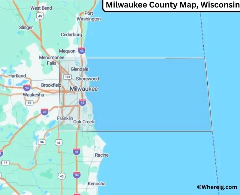
About Milwaukee County Map, Alabama: The map showing the county boundary, county seat, major cities, highways, water bodies and neighbouring counties.
Most Viewed Links
Map of Milwaukee County, Wisconsin
Facts about Milwaukee County, Wisconsin
| Country | United States |
| State | Wisconsin |
| Region | Southeastern Wisconsin |
| County Seat | Milwaukee |
| Named After | Milwaukee River (Algonquian word meaning “good land”) |
| Established | 1834 |
| Organized | 1835 |
| Coordinates | 43.02° N, 87.97° W |
| Total Area | ~242 sq mi |
| Land Area | ~241 sq mi |
| Water Area | ~1 sq mi |
| Population (2020) | 939,489 |
| Population Rank | Most populous county in Wisconsin |
| Largest City | Milwaukee |
| Main Industries | Manufacturing, Healthcare, Finance, Education |
| Major Highways | Interstate 41, Interstate 43, Interstate 94, U.S. Highway 45 |
| Time Zone | Central Time (UTC−06:00) |
| Known For | Lake Michigan shoreline, brewing history, cultural institutions |
| Official Website | https://county.milwaukee.gov |
Top Attractions in Milwaukee County, Wisconsin
- Milwaukee Art Museum – Modern and contemporary art exhibits.
- Harley-Davidson Museum – Motorcycle history and displays.
- Milwaukee County Zoo – Family-friendly animal exhibits.
- Lakefront Brewery – Brewery tours and tastings.
- Mitchell Park Horticultural Conservatory (The Domes) – Gardens and plant exhibits.
- Historic Third Ward – Shops, dining, and arts district.
- Milwaukee Public Museum – Natural history and cultural exhibits.
- Miller Park / American Family Field – Home of the Brewers.
- Veterans Park – Lakefront park and events.
- Milwaukee County Courthouse – Historic courthouse building.
List of Cities and Towns in Milwaukee County, Wisconsin
Milwaukee, West Allis, Wauwatosa, Greenfield, Oak Creek, Franklin, South Milwaukee, Cudahy, St. Francis, Glendale, Bayside, Brown Deer, Fox Point, Greendale, Hales Corners, River Hills, Shorewood, West Milwaukee, Whitefish Bay
Map of Wisconsin Counties
- Adams County Map, WI
- Ashland County Map, WI
- Barron County Map, WI
- Bayfield County Map, WI
- Brown County Map, WI
- Buffalo County Map, WI
- Burnett County Map, WI
- Calumet County Map, WI
- Chippewa County Map, WI
- Clark County Map, WI
- Columbia County Map, WI
- Crawford County Map, WI
- Dane County Map, WI
- Dodge County Map, WI
- Door County Map, WI
- Douglas County Map, WI
- Dunn County Map, WI
- Eau Claire County Map, WI
- Florence County Map, WI
- Fond Du Lac County Map, WI
- Forest County Map, WI
- Grant County Map, WI
- Green County Map, WI
- Green Lake County Map, WI
- Iowa County Map, WI
- Iron County Map, WI
- Jackson County Map, WI
- Jefferson County Map, WI
- Juneau County Map, WI
- Kenosha County Map, WI
- Kewaunee County Map, WI
- La Crosse County Map, WI
- Lafayette County Map, WI
- Langlade County Map, WI
- Lincoln County Map, WI
- Manitowoc County Map, WI
- Marathon County Map, WI
- Marinette County Map, WI
- Marquette County Map, WI
- Menominee County Map, WI
- Milwaukee County Map, WI
- Monroe County Map, WI
- Oconto County Map, WI
- Oneida County Map, WI
- Outagamie County Map, WI
- Ozaukee County Map, WI
- Pepin County Map, WI
- Pierce County Map, WI
- Polk County Map, WI
- Portage County Map, WI
- Price County Map, WI
- Racine County Map, WI
- Richland County Map, WI
- Rock County Map, WI
- Rusk County Map, WI
- Sauk County Map, WI
- Sawyer County Map, WI
- Shawano County Map, WI
- Sheboygan County Map, WI
- St Croix County Map, WI
- Taylor County Map, WI
- Trempealeau County Map, WI
- Vernon County Map, WI
- Vilas County Map, WI
- Walworth County Map, WI
- Washburn County Map, WI
- Washington County Map, WI
- Waukesha County Map, WI
- Waupaca County Map, WI
- Waushara County Map, WI
- Winnebago County Map, WI
- Wood County Map, WI
US Counties Map by State
- Alabama Counties
- Alaska boroughs
- Arizona Counties
- Arkansas Counties
- California County Map
- Colorado Counties
- Connecticut Counties
- Delaware Counties
- Florida County Map
- Georgia County Map
- Hawaii Counties
- Idaho Counties
- Illinois Counties
- Indiana Counties
- Iowa Counties
- Kansas Counties
- Kentucky Counties
- Louisiana Counties
- Maine Counties
- Maryland Counties
- Massachusetts Counties
- Michigan County Map
- Minnesota Counties
- Mississippi Counties
- Missouri Counties
- Montana Counties
- Nebraska Counties
- Nevada Counties
- New York Counties
- New Hampshire Counties
- New Jersey Counties
- New Mexico Counties
- North Carolina Counties
- North Dakota Counties
- Ohio County Map
- Oklahoma Counties
- Oregon Counties
- Pennsylvania Counties
- Rhode Island Counties
- South Carolina Counties
- South Dakota Counties
- Map of Tennessee
- Texas County Map
- Utah Counties
- Vermont Counties
- Virginia Counties
- Washington Counties
- West Virginia Counties
- Wisconsin Counties
- Wyoming Counties