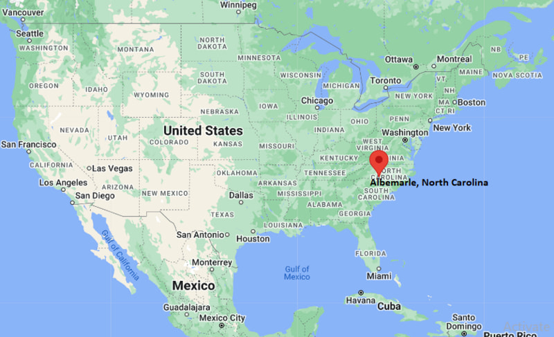
Where is Albemarle Located? - Albemarle is a city located in the Stanly County of North Carolina, United States. Albemarle lies between 35.35728 Degrees North latitudes and -80.2044 Degrees West longitudes.
Location Map of Albemarle, North Carolina
Albemarle Map, North Carolina, USA
Where is Albemarle?: The Google Map showing the location of Albemarle in the U.S. state of North Carolina.
Where is Albemarle Located?
Albemarle is a city located in Stanly County of North Carolina, United States. Albemarle lies at approximately 35.35728 Degrees North latitude and -80.2044 Degrees West longitude. According to the 2020 U.S. Census, the population of Albemarle city is 16,432 people and the city has a total area of 17.556 sq mi. The city has numerous parks and recreational facilities.
Nearby Cities and Communities to Albemarle, North Carolina
Badin, North Carolina - 5 mi Northeast
Norwood, North Carolina - 11 mi Southeast
Locust, North Carolina - 15 mi West
Oakboro, North Carolina - 14 mi Southwest
Richfield, North Carolina - 13 mi North
Troy, North Carolina - 18 mi East
Concord, North Carolina - 28 mi West
Salisbury, North Carolina - 30 mi North
Kannapolis, North Carolina - 30 mi West
Charlotte, North Carolina - 42 mi Southwest
Albemarle, North Carolina Climate and Weather Overview
Month
Avg High (°F)
Avg Low (°F)
Avg Rainfall (in)
January
51
30
3.8
April
73
47
3.4
July
89
69
4.7
October
74
49
3.1
Annual
72
49
46.0
Climate Attribute
Details
Climate Classification (Köppen)
Cfa - Humid Subtropical
Annual Rainfall
Approximately 46 inches
Annual Sunshine Days
Approximately 215 days
Severe Weather Risk
Moderate
Average Snowfall
Approximately 4 inches annually
Driving Distances from Albemarle, North Carolina
City
State
Distance (mi)
Approx. Drive Time
Badin
North Carolina
5
10 min
Norwood
North Carolina
11
15 min
Richfield
North Carolina
13
15 min
Oakboro
North Carolina
14
20 min
Locust
North Carolina
15
20 min
Troy
North Carolina
18
25 min
Concord
North Carolina
28
35 min
Salisbury
North Carolina
30
40 min
Kannapolis
North Carolina
30
40 min
Charlotte
North Carolina
42
55 min
Transportation and Connectivity in Albemarle, North Carolina
Nearest Airport
Stanly County Airport
Nearest Major Airport
Charlotte Douglas International Airport
IATA Code
CLT
Major Highways
US Highway 52, US Highway 73, NC Highway 24/27
Rail Service
Freight Rail Service
Public Transit
Stanly County Transit
US Highway 52 provides connections to Salisbury and South Carolina.
NC Highway 24/27 links Albemarle with Charlotte and Fayetteville regions.
Charlotte Douglas International Airport is approximately 50 miles southwest of the city.
Stanly County Transit offers local transportation services.
The city serves as the commercial and administrative center of Stanly County.
Key Landmarks and Places to Visit in Albemarle, North Carolina
Landmark Name
Type
Morrow Mountain State Park
State Park
Stanly County History Center
Museum
Badin Lake Recreation Area
Outdoor Recreation Area
City Lake Park
Community Park
Falling Rivers Gallery
Art Gallery
Historic Downtown Albemarle
Historic District
Uwharrie National Forest
National Forest
Rock Creek Park
Recreation Area
Badin Road Drive-In Theater
Entertainment Venue
Dennis Vineyards
Local Attraction
Colleges and Universities Near Albemarle, North Carolina
Institution Name
Type
Distance
Notable For
Stanly Community College
Community College
4 mi
Technical and workforce programs
Pfeiffer University
Private University
16 mi
Liberal arts and professional studies
Rowan-Cabarrus Community College
Community College
28 mi
Career and technical education
University of North Carolina at Charlotte
Public University
40 mi
Research and higher education
Catawba College
Private College
30 mi
Liberal arts education
Waterbodies in and Near Albemarle, North Carolina
Badin Lake, Lake Tillery, Yadkin River, Pee Dee River, Little Long Creek, Mountain Creek, Falling Creek Reservoir, Tuckertown Reservoir, High Rock Lake, Rocky River
Golf Courses in and Near Albemarle, North Carolina
Piney Point Golf Club, Tillery Tradition Country Club, Uwharrie Golf Club, Old North State Club, The Revival at the Crescent, Red Bridge Golf Club, Rocky River Golf Club, Eagle Chase Golf Club
Albemarle, North Carolina - Key Historical Facts
Albemarle was incorporated in 1857 and became the county seat of Stanly County.
The city grew through agriculture, textile manufacturing and regional trade.
Nearby aluminum production in Badin contributed significantly to the local economy during the twentieth century.
The Yadkin-Pee Dee River system helped support transportation and industrial development.
Historic downtown Albemarle preserves many early twentieth-century commercial buildings.
Today, Albemarle is known for its access to lakes, forests and outdoor recreation in the Uwharrie region.