
Where is Laurinburg Located? - Laurinburg is a city located in the Scotland County of North Carolina, United States. Laurinburg lies between 40.5773266 Degrees North latitudes and 74.2282005 Degrees West longitudes.
Location Map of Laurinburg, North Carolina
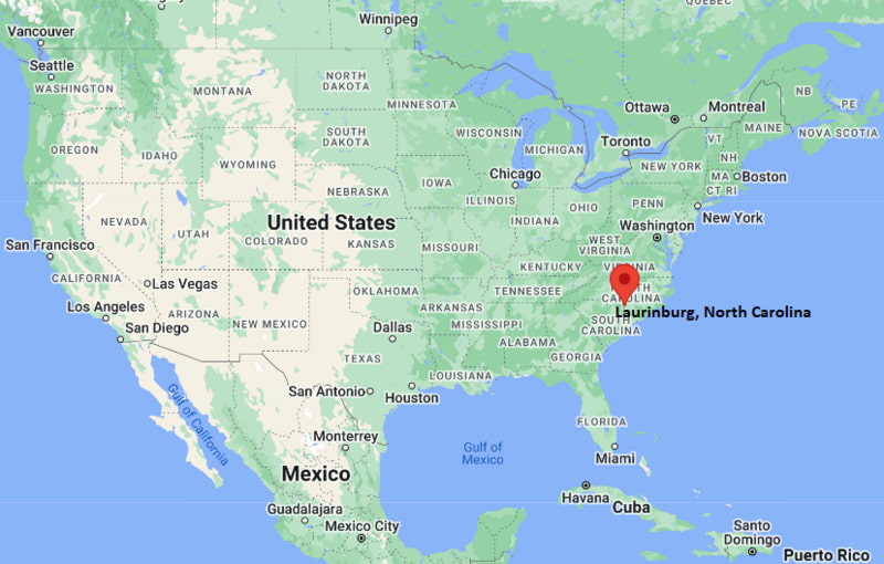
Laurinburg Map, North Carolina, USA
Where is Laurinburg?: The Google Map showing the location of Laurinburg in the U.S. state of North Carolina.
Where is Laurinburg Located?
Laurinburg is a city located in the Scotland County of North Carolina, United States. Laurinburg lies between 40.5773266 Degrees North latitudes and 74.2282005 Degrees West longitudes. According to 2020 U.S.census, the population of Laurinburg city is 14978 people and the city has a total area of 12.53 sq mi. The city has numerous parks and recreational facilities.
Most Viewed US Maps
| USA Sttae Map | USA Region Map | USA Road Map |
| USA County Map | Where is USA in World Map? | US ZIP Code Map |
| USA Time Zones Map | US State and Capitals Map | USA Physical Map |
Find 4,400+ U.S. Cities by State - Explore Their Locations and Get Detailed Information
Laurinburg, North Carolina Quick Facts
| Property | Details |
|---|---|
| City | Laurinburg |
| County | Scotland County |
| State | North Carolina |
| State Capital | Raleigh |
| US Region | Southern United States |
| Latitude | 34.7740° N |
| Longitude | 79.4628° W |
| Elevation | 218 ft (66 m) |
| Land Area | 12.55 sq mi |
| Water Area | 0.16 sq mi |
| Total Area | 12.71 sq mi |
| Population (2020 Census) | 14,978 |
| Population Density | Approximately 1,194 per sq mi |
| ZIP Code | 28352, 28353 |
| Area Code | 910 |
| Time Zone Standard | Eastern Standard Time (EST, UTC−5) |
| Time Zone Daylight | Eastern Daylight Time (EDT, UTC−4) |
| Currency | United States Dollar (USD) |
| FIPS Code | 37-37220 |
| Metropolitan Area | Fayetteville Metropolitan Area |
Transportation and Connectivity in Laurinburg
| Category | Details |
|---|---|
| Nearest Airport | Laurinburg–Maxton Airport |
| IATA Code | MEB (nearby Maxton) |
| Major Highways | U.S. Highway 74, U.S. Highway 401, Interstate 74 (nearby), Interstate 95 (nearby) |
| Public Transit | Scotland County Area Transit System |
| Nearest Rail Service | Regional freight rail service |
| Regional Access | Connected to Fayetteville, Pinehurst, Charlotte, and South Carolina communities |
- U.S. Highway 74: Provides east-west access through southern North Carolina and connects Laurinburg with larger regional markets.
- U.S. Highway 401: Provides north-south connectivity toward Fayetteville and South Carolina.
- Interstate 95: Located nearby and provides access along the major East Coast transportation corridor.
- Regional Location: Laurinburg is located in the Sandhills region of North Carolina and serves as the county seat of Scotland County. :contentReference[oaicite:1]{index=1}
Top Places to Visit in Laurinburg, North Carolina
| Landmark Name | Type |
|---|---|
| John Blue House and Heritage Center | Historic Landmark |
| North Carolina Rural Heritage Center | History Museum |
| Hammond Park | Community Park |
| Market Park | Tourist Attraction |
| Storytelling Arts Center of the Southeast | Arts Center |
| Downtown Laurinburg Art Garden | Public Art Park |
| W.H. Bryant Park | Recreation Park |
| Scotland County Historical Properties | Historic Attractions |
| Lake Johnston (nearby) | Outdoor Recreation Area |
| Lumber River State Park (nearby) | State Park |
Driving Distances from Laurinburg, North Carolina to Nearby Cities
| City | State | Distance (mi) | Approx. Drive Time |
|---|---|---|---|
| Maxton | North Carolina | 10 | 15 minutes |
| Fayetteville | North Carolina | 43 | 45 minutes |
| Pinehurst | North Carolina | 35 | 45 minutes |
| Lumberton | North Carolina | 35 | 40 minutes |
| Charlotte | North Carolina | 95 | 1 hour 45 minutes |
| Raleigh | North Carolina | 105 | 2 hours |
| Wilmington | North Carolina | 105 | 2 hours |
| Myrtle Beach | South Carolina | 100 | 2 hours |
| Columbia | South Carolina | 120 | 2 hours |
| Greensboro | North Carolina | 120 | 2 hours |
Colleges and Universities in and near Laurinburg, North Carolina
| Institution Name | Type | Level | Notable For |
|---|---|---|---|
| St. Andrews University | Private | University | Liberal arts, business, education, equestrian studies, and professional programs |
| Richmond Community College | Public | Community College | Technical education, workforce training, healthcare, and transfer programs |
| University of North Carolina at Pembroke | Public | University | Education, business, nursing, sciences, and Native American studies |
| Fayetteville State University | Public | University | Education, business, social sciences, and STEM programs |
| Fayetteville Technical Community College | Public | Community College | Career training, technology, health sciences, and workforce development |
Waterbodies in Laurinburg, North Carolina
Lumber River, Drowning Creek, Gum Swamp Creek, Big Branch Creek, Lake Johnston, Lake Paul Wallace (nearby), Lumber River State Park waterways
Stadiums in Laurinburg
Laurinburg High School Athletic Facilities, Pate Stadium, Scotland High School Athletic Complex, Knights Stadium at St. Andrews University, Grace P. Johnson Stadium (nearby Pembroke)
Laurinburg, North Carolina — Key Historical Facts
- Laurinburg was founded in the nineteenth century and developed as a center for agriculture, trade, and transportation in Scotland County.
- The city was named after John Laurin, an early settler and influential figure in the area's development.
- The arrival of the railroad in the nineteenth century helped Laurinburg grow as a regional commercial center. :contentReference[oaicite:1]{index=1}
- Laurinburg became the county seat of Scotland County in 1900 and has remained the administrative center of the region. :contentReference[oaicite:2]{index=2}
- The city has a strong agricultural heritage, historically producing crops such as tobacco, cotton, and other regional farm products. :contentReference[oaicite:3]{index=3}
- Downtown Laurinburg has been revitalized through historic preservation and community development programs as part of the North Carolina Main Street initiative. :contentReference[oaicite:4]{index=4}
- Today, Laurinburg is known for its historic downtown, arts and cultural activities, higher education institutions, and location in the Sandhills region of North Carolina. :contentReference[oaicite:5]{index=5}
References
- City of Laurinburg
- Scotland County Government
- U.S. Census Bureau
- St. Andrews University
- Lumber River State Park
North Carolina Maps and Info
- Where is Albemarle
- Where is Apex
- Where is Asheboro
- Where is Asheville
- Where is Belmont
- Where is Boone
- Where is Burlington
- Where is Carrboro
- Where is Cary
- Where is Chapel Hill
- Where is Clayton
- Where is Clemmons
- Where is Concord
- Where is Cornelius
- Where is Davidson
- Where is Eden
- Where is Elizabeth City
- Where is Fuquay-Varina
- Where is Garner
- Where is Gastonia
- Where is Goldsboro
- Where is Graham
- Where is Greenville
- Where is Harrisburg
- Where is Havelock
- Where is Hendersonville
- Where is Hickory
- Where is High Point
- Where is Holly Springs
- Where is Hope Mills
- Where is Huntersville
- Where is Indian Trail
- Where is Kannapolis
- Where is Kernersville
- Where is Kinston
- Where is Knightdale
- Where is Laurinburg
- Where is Leland
- Where is Lenoir
- Where is Lumberton
- Where is Matthews
- Where is Mebane
- Where is Mint Hill
- Where is Monroe
- Where is Mooresville
- Where is Morganton
- Where is Morrisville
- Where is Mount Holly
- Where is Murraysville
- Where is New Bern
- Where is Pinehurst
- Where is Piney Green
- Where is Reidsville
- Where is Roanoke Rapids
- Where is Rocky Mount
- Where is Salisbury
- Where is Sanford
- Where is Shelby
- Where is Southern Pines
- Where is Stallings
- Where is Statesville
- Where is Thomasville
- Where is Wake Forest
- Where is Waxhaw
- Where is Wilmington
- Where is Wilson
- Where is Winston-Salem