
Where is Belmont Located? - Belmont is a city located in the Belknap County of North Carolina, United States. Belmont lies between 35.24403 Degrees North latitudes and -81.044 Degrees West longitudes.
Location Map of Belmont, North Carolina
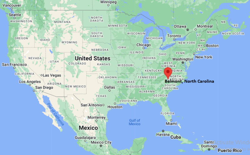
Belmont Map, North Carolina, USA
Where is Belmont?: The Google Map showing the location of Belmont in the U.S. state of North Carolina.
Where is Belmont Located?
Belmont is a city located in the Gaston County of North Carolina, United States. Belmont lies at approximately 35.24403 Degrees North latitude and -81.044 Degrees West longitude. According to the 2020 U.S. Census, the population of Belmont city is 15,010 people and the city has a total area of 12.139 sq mi. The city has numerous parks and recreational facilities.
Most Viewed US Maps
| USA Sttae Map | USA Region Map | USA Road Map |
| USA County Map | Where is USA in World Map? | US ZIP Code Map |
| USA Time Zones Map | US State and Capitals Map | USA Physical Map |
Find 4,400+ U.S. Cities by State - Explore Their Locations and Get Detailed Information
Belmont, North Carolina Quick Facts
| Fact | Details |
|---|---|
| City | Belmont |
| County | Gaston County |
| State | North Carolina |
| State Capital | Raleigh |
| Country | United States |
| US Region | South |
| Latitude | 35.24403 N |
| Longitude | -81.044 W |
| Elevation | 705 ft (215 m) |
| Land Area | 12.1 sq mi |
| Water Area | 0.3 sq mi |
| Total Area | 12.139 sq mi |
| Population (Census 2020) | 15,471 |
| Population Density | Approximately 1,279 per sq mi |
| ZIP Code | 28012 |
| Area Code | 704, 980 |
| Time Zone Standard | Eastern Standard Time (EST, UTC-5) |
| Time Zone Daylight | Eastern Daylight Time (EDT, UTC-4) |
| Currency | United States Dollar (USD) |
| FIPS Code | 37-05220 |
| Congressional District | North Carolina's 14th Congressional District |
Nearby Cities to Belmont, North Carolina
- Mount Holly, North Carolina - 3 mi North
- Cramerton, North Carolina - 4 mi West
- Gastonia, North Carolina - 10 mi West
- Charlotte, North Carolina - 13 mi East
- Ranlo, North Carolina - 12 mi West
- Lowell, North Carolina - 9 mi Northwest
- McAdenville, North Carolina - 8 mi West
- Pineville, North Carolina - 18 mi Southeast
- Huntersville, North Carolina - 19 mi Northeast
- Rock Hill, South Carolina - 25 mi South
Belmont, North Carolina Climate and Weather Overview
| Month | Avg High (°F) | Avg Low (°F) | Avg Rainfall (in) |
|---|---|---|---|
| January | 52 | 31 | 3.7 |
| April | 73 | 48 | 3.2 |
| July | 90 | 70 | 4.0 |
| October | 74 | 50 | 3.3 |
| Annual | 72 | 50 | 43.5 |
| Climate Attribute | Details |
|---|---|
| Climate Classification | Humid Subtropical (Köppen Cfa) |
| Annual Rainfall | Approximately 44 inches |
| Annual Sunshine Days | About 218 days |
| Hurricane/Tornado Risk | Moderate - Thunderstorms, occasional tropical systems and isolated tornadoes |
| Snowfall | Approximately 4 inches annually |
Driving Distances from Belmont, North Carolina
| City | State | Distance (mi) | Approx. Drive Time |
|---|---|---|---|
| Mount Holly | North Carolina | 3 | 7 min |
| Cramerton | North Carolina | 4 | 8 min |
| McAdenville | North Carolina | 8 | 12 min |
| Lowell | North Carolina | 9 | 15 min |
| Gastonia | North Carolina | 10 | 18 min |
| Charlotte | North Carolina | 13 | 20 min |
| Ranlo | North Carolina | 12 | 18 min |
| Pineville | North Carolina | 18 | 28 min |
| Huntersville | North Carolina | 19 | 28 min |
| Rock Hill | South Carolina | 25 | 35 min |
Transportation and Connectivity in Belmont, North Carolina
| Transportation | Details |
|---|---|
| Airport Name | Charlotte Douglas International Airport |
| IATA Code | CLT |
| Port | Not Applicable |
| Major Highways | Interstate 85, U.S. Highway 29/74, NC Highway 7, NC Highway 273 |
| Train/Amtrak Service | Nearest Amtrak station in Charlotte |
| Local Bus/Transit Service | Gaston County Transit and Charlotte Area Transit System (nearby) |
- Interstate 85 - Primary interstate connecting Belmont with Charlotte, Gastonia, Greensboro and Atlanta.
- U.S. Highway 29/74 - Major corridor linking Belmont with western Gaston County and central Charlotte.
- North Carolina Highway 7 - Connects Belmont with Cramerton, McAdenville and surrounding communities.
- North Carolina Highway 273 - Provides access to Mount Holly, Interstate 85 and local commercial districts.
Key Landmarks and Places to Visit in Belmont, North Carolina
| Landmark | Type |
|---|---|
| Daniel Stowe Botanical Garden | Botanical Garden |
| Belmont Abbey College | Historic College Campus |
| Belmont Abbey Basilica | Historic Church |
| Kevin Loftin Riverfront Park | Riverfront Park |
| Stowe Park | City Park |
| Rocky Branch Park | Nature Park |
| Catawba River Greenway | Walking and Cycling Trail |
| U.S. National Whitewater Center | Outdoor Recreation Center |
| Belmont Historic Downtown | Historic District |
| Goat Island Park | Riverside Park |
Colleges and Universities in Belmont, North Carolina
| Institution | Type | Level | Notable For |
|---|---|---|---|
| Belmont Abbey College | Private | College | Liberal arts and Catholic education |
| Gaston College | Public | Community College | Career and transfer programs |
| University of North Carolina at Charlotte | Public | University | Engineering and research |
| Johnson C. Smith University | Private | University | Liberal arts and business |
| Queens University of Charlotte | Private | University | Business and health sciences |
| Central Piedmont Community College | Public | Community College | Technical and workforce education |
Waterbodies in Belmont, North Carolina
Catawba River, Lake Wylie, South Fork Catawba River, Mountain Island Lake, Dutchmans Creek, Long Creek, Crowders Creek, Kevin Loftin Riverfront shoreline, Gar Creek, Beaver Dam Creek.
Golf Courses in Belmont, North Carolina
Gaston Country Club, Cramer Mountain Club, Charles T. Myers Golf Course, Carolina Lakes Golf Club, Springfield Golf Club, Verdict Ridge Golf & Country Club, Highland Creek Golf Club, Pine Island Country Club.
Belmont, North Carolina - Key Historical Facts
- Belmont was incorporated in 1895 and developed as a thriving textile manufacturing community along the Catawba River.
- The establishment of Belmont Abbey College in the late nineteenth century helped shape the city's educational and cultural identity.
- Textile mills powered much of the local economy throughout the twentieth century, attracting workers and supporting steady population growth.
- The city's historic downtown preserves many early commercial buildings that reflect Belmont's industrial heritage.
- Its location near Charlotte has encouraged residential, commercial and economic expansion while maintaining a small-town atmosphere.
- Today, Belmont is known for its vibrant downtown, riverfront parks, historic landmarks and convenient access to the Charlotte metropolitan area.
References
North Carolina Maps and Info
- Where is Albemarle
- Where is Apex
- Where is Asheboro
- Where is Asheville
- Where is Belmont
- Where is Boone
- Where is Burlington
- Where is Carrboro
- Where is Cary
- Where is Chapel Hill
- Where is Clayton
- Where is Clemmons
- Where is Concord
- Where is Cornelius
- Where is Davidson
- Where is Eden
- Where is Elizabeth City
- Where is Fuquay-Varina
- Where is Garner
- Where is Gastonia
- Where is Goldsboro
- Where is Graham
- Where is Greenville
- Where is Harrisburg
- Where is Havelock
- Where is Hendersonville
- Where is Hickory
- Where is High Point
- Where is Holly Springs
- Where is Hope Mills
- Where is Huntersville
- Where is Indian Trail
- Where is Kannapolis
- Where is Kernersville
- Where is Kinston
- Where is Knightdale
- Where is Laurinburg
- Where is Leland
- Where is Lenoir
- Where is Lumberton
- Where is Matthews
- Where is Mebane
- Where is Mint Hill
- Where is Monroe
- Where is Mooresville
- Where is Morganton
- Where is Morrisville
- Where is Mount Holly
- Where is Murraysville
- Where is New Bern
- Where is Pinehurst
- Where is Piney Green
- Where is Reidsville
- Where is Roanoke Rapids
- Where is Rocky Mount
- Where is Salisbury
- Where is Sanford
- Where is Shelby
- Where is Southern Pines
- Where is Stallings
- Where is Statesville
- Where is Thomasville
- Where is Wake Forest
- Where is Waxhaw
- Where is Wilmington
- Where is Wilson
- Where is Winston-Salem