
Where is Mint Hill Located? - Mint Hill is a city located in the Mecklenburg, Union County of North Carolina, United States. Mint Hill lies between 40.6687141 Degrees North latitudes and 74.1143091 Degrees West longitudes.
Location Map of Mint Hill, North Carolina
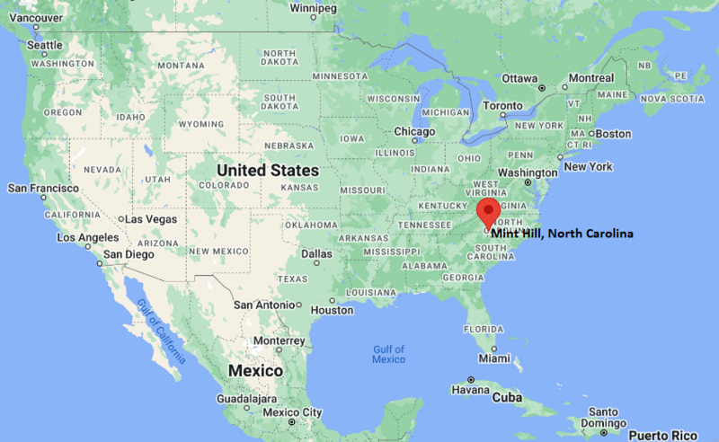
Mint Hill Map, North Carolina, USA
Where is Mint Hill?: The Google Map showing the location of Mint Hill in the U.S. state of North Carolina.
Where is Mint Hill Located?
Mint Hill is a city located in the Mecklenburg, Union County of North Carolina, United States. Mint Hill lies between 40.6687141 Degrees North latitudes and 74.1143091 Degrees West longitudes. According to 2020 U.S.census, the population of Mint Hill city is 26450 people and the city has a total area of 24.16 sq mi. The city has numerous parks and recreational facilities.
Most Viewed US Maps
| USA Sttae Map | USA Region Map | USA Road Map |
| USA County Map | Where is USA in World Map? | US ZIP Code Map |
| USA Time Zones Map | US State and Capitals Map | USA Physical Map |
Find 4,400+ U.S. Cities by State - Explore Their Locations and Get Detailed Information
Mint Hill, North Carolina Quick Facts
| Attribute | Information |
|---|---|
| City | Mint Hill |
| County | Mecklenburg County and Union County |
| State | North Carolina |
| State Capital | Raleigh |
| US Region | South Atlantic |
| Latitude | 35.1798° N |
| Longitude | 80.6476° W |
| Elevation | 722 ft (220 m) |
| Land Area | 24.83 sq mi |
| Water Area | 0.07 sq mi |
| Total Area | 24.90 sq mi |
| Population (2020 Census) | 26,236 |
| Population Density | Approximately 1,057 per sq mi |
| ZIP Codes | 28227, 28215, 28105 |
| Area Code | 704, 980 |
| Time Zone Standard | Eastern Standard Time (EST, UTC−5) |
| Time Zone Daylight | Eastern Daylight Time (EDT, UTC−4) |
| Currency | United States Dollar (USD) |
| FIPS Code | 37-43520 |
| Congressional District | North Carolina's 12th and 8th Congressional Districts |
Transportation and Connectivity in Mint Hill
| Category | Information |
|---|---|
| Airport Name | Charlotte Douglas International Airport |
| IATA Code | CLT |
| Port | Not applicable |
| Major Highways | U.S. Highway 74, Interstate 485, North Carolina Highway 51 |
| Train/Amtrak Service | Nearest Amtrak station is Charlotte |
| Local Bus/Transit Service | Charlotte Area Transit System (CATS) and regional transit connections |
- U.S. Highway 74 (Independence Boulevard) – Major east–west corridor connecting Mint Hill with Charlotte and Monroe.
- Interstate 485 – Outer beltway providing access to Charlotte suburbs, the airport, and regional interstates.
- North Carolina Highway 51 (Matthews–Mint Hill Road) – Connects Mint Hill with Matthews, Pineville, and surrounding communities.
- Lawyers Road – Important local route linking residential neighborhoods with central Mint Hill and eastern Mecklenburg County.
Top Places to Visit in Mint Hill, North Carolina
| Landmark Name | Type |
|---|---|
| Carl J. McEwen Historic Village | Historic Site |
| Mint Hill Veterans Memorial Park | Park |
| Stevens Creek Nature Preserve | Nature Preserve |
| Mint Hill Arts | Art Gallery |
| Philadelphia Presbyterian Church Historic Cemetery | Historic Site |
| Wilgrove Park | Park |
| Park on Wilgrove | Recreation Area |
| Colonel Francis Beatty Park | Regional Park |
| Mint Hill Town Hall Plaza | Civic Landmark |
| Idlewild Road Park | Park |
Driving Distances from Mint Hill, North Carolina to Nearby Cities
| City | State | Distance (mi) | Approx. Drive Time |
|---|---|---|---|
| Charlotte | North Carolina | 14 | 25 minutes |
| Matthews | North Carolina | 5 | 10 minutes |
| Monroe | North Carolina | 16 | 25 minutes |
| Indian Trail | North Carolina | 8 | 15 minutes |
| Pineville | North Carolina | 17 | 30 minutes |
| Concord | North Carolina | 20 | 30 minutes |
| Huntersville | North Carolina | 28 | 35 minutes |
| Gastonia | North Carolina | 34 | 45 minutes |
| Salisbury | North Carolina | 47 | 55 minutes |
| Rock Hill | South Carolina | 33 | 45 minutes |
Colleges and Universities in Mint Hill, North Carolina
| Institution Name | Type | Level | Notable For |
|---|---|---|---|
| University of North Carolina at Charlotte | Public | University | Research and engineering programs |
| Central Piedmont Community College | Public | Community College | Career and transfer education |
| Wingate University | Private | University | Health sciences and pharmacy |
| Queens University of Charlotte | Private | University | Liberal arts and business programs |
| Johnson C. Smith University | Private | University | Historically Black liberal arts education |
Waterbodies in Mint Hill, North Carolina
Stevens Creek, Clear Creek, Goose Creek, Four Mile Creek, McAlpine Creek, Lake Twitty, Lake Matthews, Catawba River.
Stadiums in Mint Hill
Rocky River High School Stadium, Independence High School Patriot Stadium, Mecklenburg County Sportsplex at Matthews, American Legion Memorial Stadium, Bank of America Stadium.
Mint Hill, North Carolina — Key Historical Facts
- Mint Hill was first settled during the eighteenth century by farming families attracted to the area's fertile land and natural resources.
- The town's name is believed to have originated from a small branch mint established in the community during the Carolina Gold Rush era.
- For much of its history, Mint Hill remained a rural agricultural community centered on cotton farming and local commerce.
- The town was officially incorporated in 1971 as residents sought to preserve their community's identity amid Charlotte's suburban expansion.
- Today, Mint Hill combines historic sites with modern neighborhoods while maintaining a strong small-town atmosphere within the Charlotte metropolitan area.
References
North Carolina Maps and Info
- Where is Albemarle
- Where is Apex
- Where is Asheboro
- Where is Asheville
- Where is Belmont
- Where is Boone
- Where is Burlington
- Where is Carrboro
- Where is Cary
- Where is Chapel Hill
- Where is Clayton
- Where is Clemmons
- Where is Concord
- Where is Cornelius
- Where is Davidson
- Where is Eden
- Where is Elizabeth City
- Where is Fuquay-Varina
- Where is Garner
- Where is Gastonia
- Where is Goldsboro
- Where is Graham
- Where is Greenville
- Where is Harrisburg
- Where is Havelock
- Where is Hendersonville
- Where is Hickory
- Where is High Point
- Where is Holly Springs
- Where is Hope Mills
- Where is Huntersville
- Where is Indian Trail
- Where is Kannapolis
- Where is Kernersville
- Where is Kinston
- Where is Knightdale
- Where is Laurinburg
- Where is Leland
- Where is Lenoir
- Where is Lumberton
- Where is Matthews
- Where is Mebane
- Where is Mint Hill
- Where is Monroe
- Where is Mooresville
- Where is Morganton
- Where is Morrisville
- Where is Mount Holly
- Where is Murraysville
- Where is New Bern
- Where is Pinehurst
- Where is Piney Green
- Where is Reidsville
- Where is Roanoke Rapids
- Where is Rocky Mount
- Where is Salisbury
- Where is Sanford
- Where is Shelby
- Where is Southern Pines
- Where is Stallings
- Where is Statesville
- Where is Thomasville
- Where is Wake Forest
- Where is Waxhaw
- Where is Wilmington
- Where is Wilson
- Where is Winston-Salem