Map of Mecklenburg County - Mecklenburg County is a county located in the U.S. state of North Carolina. Mecklenburg County Map showing cities, highways, important places and water bodies. Get Where is Mecklenburg County located in the map, major cities in Mecklenburg county, population, areas, and places of interest.
Map of Mecklenburg County, North Carolina
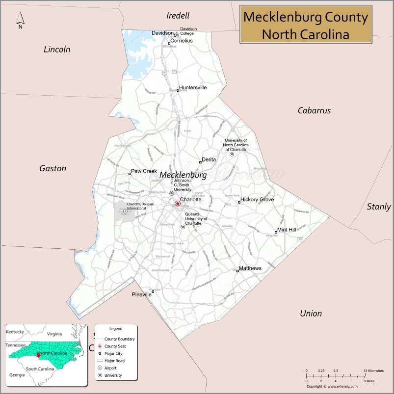
About Mecklenburg County Map, North Carolina: The map showing the county boundary, county seat, major cities, highways, water bodies and neighbouring counties.
Related North Carolina Links
About Mecklenburg County, North Carolina
Mecklenburg County is a county located in the U.S. state of North Carolina. It's county seat is Charlotte. As per 2020 census, the population of Mecklenburg County is 1122276 people and population density is square miles. According to the United States Census Bureau, the county has a total area of 546 sq mi (1,414 km2). Mecklenburg County was established on 1762.
Mecklenburg County Facts
| Continent | North America |
| Country | United States |
| State | North Carolina |
| County Seat | Charlotte |
| Largest City/Town | Charlotte |
| Established | 1762 |
| Total Area | 546 sq mi (1,414 sq km) |
| Land Area | 524 sq mi (1,357 sq km) |
| Water Area | 22 sq mi (57 sq km) |
| Population | 1,115,482 (Census 2020) |
| Population Density | 2,129 people per sq mi |
| Time Zone | Eastern Time Zone (ET) |
| Major Highways | I-77, I-85, I-485, US-74, US-29 |
| Major Rivers | Catawba River |
| Neighboring Counties | Iredell County, Cabarrus County, Union County, Gaston County, Lincoln County, York County (SC) |
| Famous For | Charlotte skyline, banking industry, NASCAR Hall of Fame |
| Top Attractions | NASCAR Hall of Fame, Discovery Place Science, Freedom Park, U.S. National Whitewater Center |
| Official Website | Official Website |
About Mecklenburg County, North Carolina
Mecklenburg County is located in the south-central part of North Carolina, in the state of the United States, and was established in 1762. The county seat is Charlotte, which is also the largest city. The county lies within the Piedmont region and is known as a major financial hub, home to one of the largest banking centers in the United States, along with a vibrant cultural and business environment.
Cities and Towns in Mecklenburg County, North Carolina
| City/Town | Population (Census 2020) | Latitude & Longitude |
|---|---|---|
| Charlotte (county seat) | 874,579 | 35.2271°N, 80.8431°W |
| Cornelius | 31,412 | 35.4868°N, 80.8601°W |
| Huntersville | 61,376 | 35.4107°N, 80.8429°W |
| Matthews | 29,435 | 35.1168°N, 80.7237°W |
| Mint Hill | 26,688 | 35.1796°N, 80.6470°W |
| Pineville | 10,602 | 35.0832°N, 80.8814°W |
| Davidson (partly in Iredell County) | 15,106 | 35.5024°N, 80.8487°W |
Golf Courses in Mecklenburg County, North Carolina
| Golf Course | Location | Latitude & Longitude |
|---|---|---|
| Quail Hollow Club | Charlotte | 35.0950°N, 80.8420°W |
| Ballantyne Country Club | Charlotte | 35.0540°N, 80.8100°W |
| NorthStone Country Club | Huntersville | 35.4200°N, 80.8500°W |
Roads and Highways in Mecklenburg County, North Carolina
Mecklenburg County is a major transportation hub in North Carolina with extensive highway infrastructure.
- I-77 – connects Charlotte to South Carolina and Ohio
- I-85 – major interstate linking the county to Atlanta and Greensboro
- I-485 – outer beltway around Charlotte
- US-74 – runs east–west through the county
- US-29 – provides regional access
Neighboring Counties of Mecklenburg County
- Iredell County (north)
- Cabarrus County (northeast)
- Union County (southeast)
- Gaston County (west)
- Lincoln County (northwest)
- York County, South Carolina (south)
Top Attractions in Mecklenburg County, North Carolina
The county offers a wide range of urban attractions, entertainment, and outdoor recreation.
- NASCAR Hall of Fame – interactive exhibits celebrating motorsports history
- Discovery Place Science – science museum with hands-on exhibits
- Freedom Park – large urban park with trails and events
- U.S. National Whitewater Center – outdoor recreation including rafting and zip-lining
- Bank of America Stadium – home of the Carolina Panthers
- Downtown Charlotte – business district with dining, shopping, and entertainment
Distance from Mecklenburg County to Nearby Cities
- Charlotte to Greensboro – 90 mi (145 km)
- Charlotte to Raleigh – 170 mi (274 km)
- Charlotte to Atlanta, GA – 245 mi (394 km)
- Charlotte to Columbia, SC – 95 mi (153 km)
- Charlotte to Asheville – 130 mi (209 km)
FAQs about Mecklenburg County
Mecklenburg County is located in south-central North Carolina and includes the city of Charlotte.
The population of Mecklenburg County is 1,115,482 according to the 2020 Census.
Mecklenburg County is known for Charlotte, its banking industry, and major attractions like the NASCAR Hall of Fame.
Major highways include I-77, I-85, I-485, US-74, and US-29.
Yes, Mecklenburg County has several golf courses including Quail Hollow Club and Ballantyne Country Club.
- Alamance County Map
- Alexander County Map
- Alleghany County Map
- Anson County Map
- Ashe County Map
- Avery County Map
- Beaufort County Map
- Bertie County Map
- Bladen County Map
- Brunswick County Map
- Buncombe County Map
- Burke County Map
- Cabarrus County Map
- Caldwell County Map
- Camden County Map
- Carteret County Map
- Caswell County Map
- Catawba County Map
- Chatham County Map
- Cherokee County Map
- Chowan County Map
- Clay County Map
- Cleveland County Map
- Columbus County Map
- Craven County Map
- Cumberland County Map
- Currituck County Map
- Dare County Map
- Davidson County Map
- Davie County Map
- Duplin County Map
- Durham County Map
- Edgecombe County Map
- Forsyth County Map
- Franklin County Map
- Gaston County Map
- Gates County Map
- Graham County Map
- Granville County Map
- Greene County Map
- Guilford County Map
- Halifax County Map
- Harnett County Map
- Haywood County Map
- Henderson County Map
- Hertford County Map
- Hoke County Map
- Hyde County Map
- Iredell County Map
- Jackson County Map
- Johnston County Map
- Jones County Map
- Lee County Map
- Lenoir County Map
- Lincoln County Map
- McDowell County Map
- Macon County Map
- Madison County Map
- Martin County Map
- Mecklenburg County Map
- Mitchell County Map
- Montgomery County Map
- Moore County Map
- Nash County Map
- New Hanover County Map
- Northampton County Map
- Onslow County Map
- Orange County Map
- Pamlico County Map
- Pasquotank County Map
- Pender County Map
- Perquimans County Map
- Person County Map
- Pitt County Map
- Polk County Map
- Randolph County Map
- Richmond County Map
- Robeson County Map
- Rockingham County Map
- Rowan County Map
- Rutherford County Map
- Sampson County Map
- Scotland County Map
- Stanly County Map
- Stokes County Map
- Surry County Map
- Swain County Map
- Transylvania County Map
- Tyrrell County Map
- Union County Map
- Vance County Map
- Wake County Map
- Warren County Map
- Washington County Map
- Watauga County Map
- Wayne County Map
- Wilkes County Map
- Wilson County Map
- Yadkin County Map
- Yancey County Map
- Alabama Counties
- Alaska boroughs
- Arizona Counties
- Arkansas Counties
- California County Map
- Colorado Counties
- Connecticut Counties
- Delaware Counties
- Florida County Map
- Georgia County Map
- Hawaii Counties
- Idaho Counties
- Illinois Counties
- Indiana Counties
- Iowa Counties
- Kansas Counties
- Kentucky Counties
- Louisiana Counties
- Maine Counties
- Maryland Counties
- Massachusetts Counties
- Michigan County Map
- Minnesota Counties
- Mississippi Counties
- Missouri Counties
- Montana Counties
- Nebraska Counties
- Nevada Counties
- New York Counties
- New Hampshire Counties
- New Jersey Counties
- New Mexico Counties
- North Carolina Counties
- North Dakota Counties
- Ohio County Map
- Oklahoma Counties
- Oregon Counties
- Pennsylvania Counties
- Rhode Island Counties
- South Carolina Counties
- South Dakota Counties
- Map of Tennessee
- Texas County Map
- Utah Counties
- Vermont Counties
- Virginia Counties
- Washington Counties
- West Virginia Counties
- Wisconsin Counties
- Wyoming Counties