
Map of Transylvania County - Transylvania County is a county located in the U.S. state of North Carolina. Transylvania County Map showing cities, highways, important places and water bodies. Get Where is Transylvania County located in the map, major cities in Transylvania county, population, areas, and places of interest.
Map of Transylvania County, North Carolina
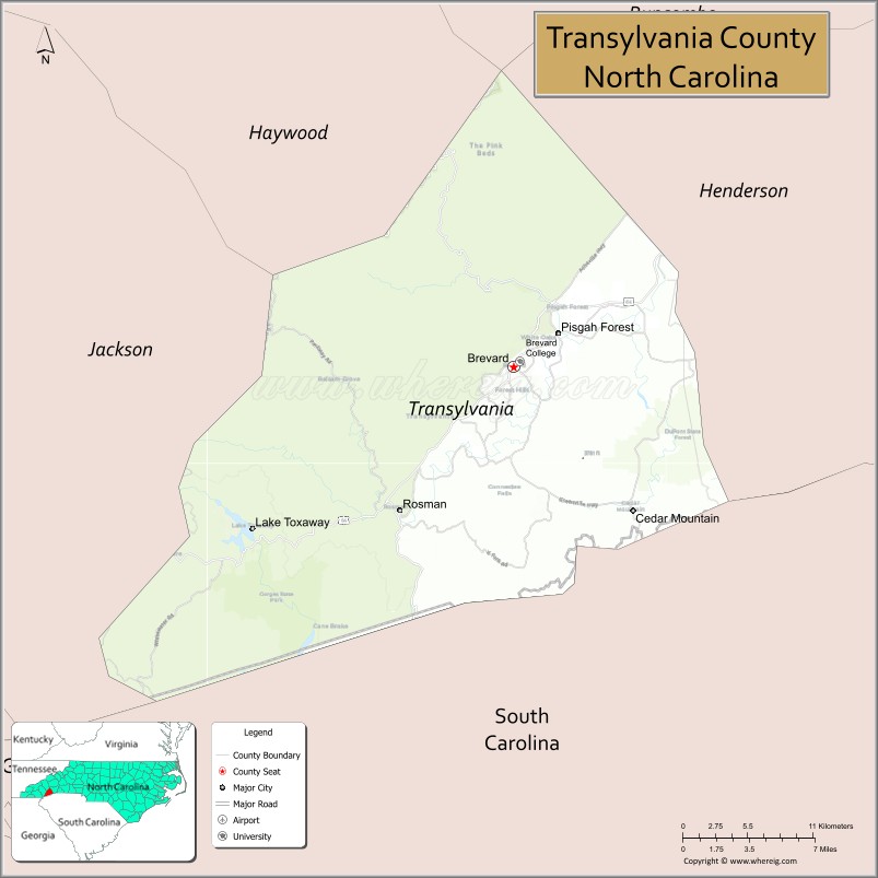
About Transylvania County Map, North Carolina: The map showing the county boundary, county seat, major cities, highways, water bodies and neighbouring counties.
Related North Carolina Links
About Transylvania County, North Carolina
Transylvania County is a county located in the U.S. state of North Carolina. It's county seat is Brevard. As per 2020 census, the population of Transylvania County is 33165 people and population density is square miles. According to the United States Census Bureau, the county has a total area of 381 sq mi (987 km2). Transylvania County was established on 1861.
Transylvania County Facts
| Continent | North America |
| Country | United States |
| State | North Carolina |
| County Seat | Brevard |
| Largest City/Town | Brevard |
| Established | 1861 |
| Total Area | 381 sq mi (987 sq km) |
| Land Area | 379 sq mi (982 sq km) |
| Water Area | 2 sq mi (5 sq km) |
| Population | 34,215 (Census 2020) |
| Population Density | 90 people per sq mi |
| Time Zone | Eastern Time Zone (ET) |
| Major Highways | US-64, US-276, NC-280 |
| Major Rivers | French Broad River, Davidson River |
| Neighboring Counties | Henderson County, Jackson County, Haywood County, Greenville County (SC), Pickens County (SC) |
| Famous For | Waterfalls, Pisgah National Forest, outdoor recreation |
| Top Attractions | Pisgah National Forest, DuPont State Recreational Forest, Looking Glass Falls, Sliding Rock |
| Official Website | Official Website |
About Transylvania County, North Carolina
Transylvania County is located in the western part of North Carolina, in the state of the United States, and was established in 1861. The county seat is Brevard, which is also the largest town. The county lies in the Blue Ridge Mountains and is widely known as the “Land of Waterfalls,” featuring hundreds of waterfalls, scenic forests, and abundant outdoor recreation opportunities.
Cities and Towns in Transylvania County, North Carolina
| City/Town | Population (Census 2020) | Latitude & Longitude |
|---|---|---|
| Brevard (county seat) | 7,609 | 35.2334°N, 82.7343°W |
| Rosman | 600 | 35.1400°N, 82.8300°W |
| Cedar Mountain (CDP) | 800 | 35.1600°N, 82.6300°W |
| Lake Toxaway (CDP) | 1,200 | 35.1200°N, 82.9500°W |
| Pisgah Forest (CDP) | 5,000+ | 35.2800°N, 82.6800°W |
Golf Courses in Transylvania County, North Carolina
| Golf Course | Location | Latitude & Longitude |
|---|---|---|
| Brevard Country Club | Brevard | 35.2300°N, 82.7300°W |
| Lake Toxaway Country Club | Lake Toxaway | 35.1200°N, 82.9500°W |
Roads and Highways in Transylvania County, North Carolina
Transylvania County is connected by scenic mountain highways serving western North Carolina.
- US-64 – major east–west route through the county
- US-276 – connects Brevard to the Blue Ridge Parkway and Pisgah National Forest
- NC-280 – links the county to Asheville and surrounding areas
Neighboring Counties of Transylvania County
- Henderson County (north)
- Haywood County (northwest)
- Jackson County (west)
- Greenville County, South Carolina (south)
- Pickens County, South Carolina (southwest)
Top Attractions in Transylvania County, North Carolina
The county offers waterfalls, forests, and outdoor recreation.
- Pisgah National Forest – hiking, biking, and scenic beauty
- DuPont State Recreational Forest – waterfalls and filming locations
- Looking Glass Falls – one of the most popular waterfalls in the area
- Sliding Rock – natural water slide attraction
- Blue Ridge Parkway (nearby) – scenic drives and mountain views
- Downtown Brevard – shops, dining, and arts scene
Distance from Transylvania County to Nearby Cities
- Brevard to Asheville – 35 mi (56 km)
- Brevard to Greenville, SC – 45 mi (72 km)
- Brevard to Charlotte – 120 mi (193 km)
- Brevard to Atlanta, GA – 140 mi (225 km)
- Brevard to Knoxville, TN – 120 mi (193 km)
FAQs about Transylvania County
Transylvania County is located in western North Carolina in the Blue Ridge Mountains.
The population of Transylvania County is 34,215 according to the 2020 Census.
Transylvania County is known as the “Land of Waterfalls” and for its outdoor recreation opportunities.
Major highways include US-64, US-276, and NC-280.
Yes, Transylvania County has golf courses including Brevard Country Club and Lake Toxaway Country Club.
- Alamance County Map
- Alexander County Map
- Alleghany County Map
- Anson County Map
- Ashe County Map
- Avery County Map
- Beaufort County Map
- Bertie County Map
- Bladen County Map
- Brunswick County Map
- Buncombe County Map
- Burke County Map
- Cabarrus County Map
- Caldwell County Map
- Camden County Map
- Carteret County Map
- Caswell County Map
- Catawba County Map
- Chatham County Map
- Cherokee County Map
- Chowan County Map
- Clay County Map
- Cleveland County Map
- Columbus County Map
- Craven County Map
- Cumberland County Map
- Currituck County Map
- Dare County Map
- Davidson County Map
- Davie County Map
- Duplin County Map
- Durham County Map
- Edgecombe County Map
- Forsyth County Map
- Franklin County Map
- Gaston County Map
- Gates County Map
- Graham County Map
- Granville County Map
- Greene County Map
- Guilford County Map
- Halifax County Map
- Harnett County Map
- Haywood County Map
- Henderson County Map
- Hertford County Map
- Hoke County Map
- Hyde County Map
- Iredell County Map
- Jackson County Map
- Johnston County Map
- Jones County Map
- Lee County Map
- Lenoir County Map
- Lincoln County Map
- McDowell County Map
- Macon County Map
- Madison County Map
- Martin County Map
- Mecklenburg County Map
- Mitchell County Map
- Montgomery County Map
- Moore County Map
- Nash County Map
- New Hanover County Map
- Northampton County Map
- Onslow County Map
- Orange County Map
- Pamlico County Map
- Pasquotank County Map
- Pender County Map
- Perquimans County Map
- Person County Map
- Pitt County Map
- Polk County Map
- Randolph County Map
- Richmond County Map
- Robeson County Map
- Rockingham County Map
- Rowan County Map
- Rutherford County Map
- Sampson County Map
- Scotland County Map
- Stanly County Map
- Stokes County Map
- Surry County Map
- Swain County Map
- Transylvania County Map
- Tyrrell County Map
- Union County Map
- Vance County Map
- Wake County Map
- Warren County Map
- Washington County Map
- Watauga County Map
- Wayne County Map
- Wilkes County Map
- Wilson County Map
- Yadkin County Map
- Yancey County Map
- Alabama Counties
- Alaska boroughs
- Arizona Counties
- Arkansas Counties
- California County Map
- Colorado Counties
- Connecticut Counties
- Delaware Counties
- Florida County Map
- Georgia County Map
- Hawaii Counties
- Idaho Counties
- Illinois Counties
- Indiana Counties
- Iowa Counties
- Kansas Counties
- Kentucky Counties
- Louisiana Counties
- Maine Counties
- Maryland Counties
- Massachusetts Counties
- Michigan County Map
- Minnesota Counties
- Mississippi Counties
- Missouri Counties
- Montana Counties
- Nebraska Counties
- Nevada Counties
- New York Counties
- New Hampshire Counties
- New Jersey Counties
- New Mexico Counties
- North Carolina Counties
- North Dakota Counties
- Ohio County Map
- Oklahoma Counties
- Oregon Counties
- Pennsylvania Counties
- Rhode Island Counties
- South Carolina Counties
- South Dakota Counties
- Map of Tennessee
- Texas County Map
- Utah Counties
- Vermont Counties
- Virginia Counties
- Washington Counties
- West Virginia Counties
- Wisconsin Counties
- Wyoming Counties