Map of Lee County - Lee County is a county located in the U.S. state of North Carolina. Lee County Map showing cities, highways, important places and water bodies. Get Where is Lee County located in the map, major cities in Lee county, population, areas, and places of interest.
Map of Lee County, North Carolina
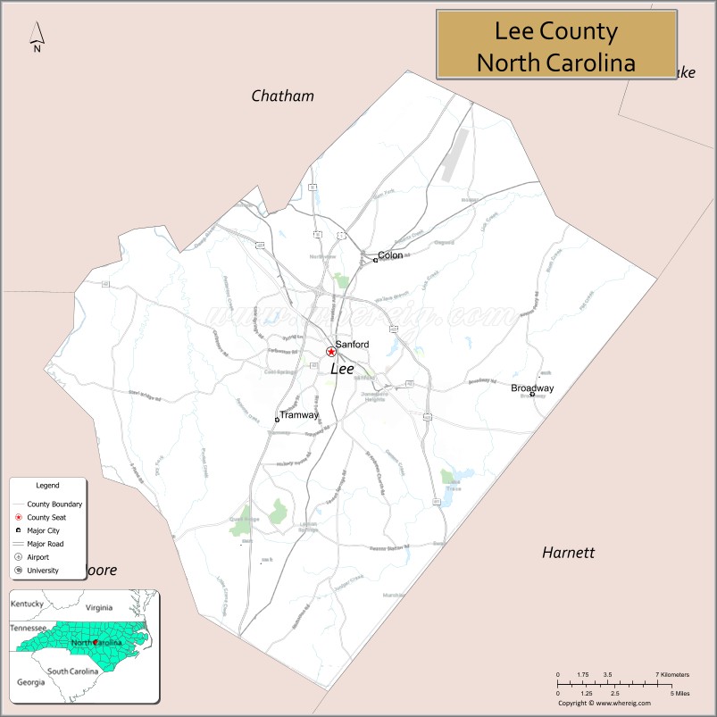
About Lee County Map, North Carolina: The map showing the county boundary, county seat, major cities, highways, water bodies and neighbouring counties.
Related North Carolina Links
About Lee County, North Carolina
Lee County is a county located in the U.S. state of North Carolina. It's county seat is Sanford. As per 2020 census, the population of Lee County is 64138 people and population density is square miles. According to the United States Census Bureau, the county has a total area of 259 sq mi (671 km2). Lee County was established on 1907.
Lee County Facts
| Continent | North America |
| Country | United States |
| State | North Carolina |
| County Seat | Sanford |
| Largest City/Town | Sanford |
| Established | 1907 |
| Total Area | 259 sq mi (671 sq km) |
| Land Area | 255 sq mi (660 sq km) |
| Water Area | 4 sq mi (11 sq km) |
| Population | 63,285 (Census 2020) |
| Population Density | 248 people per sq mi |
| Time Zone | Eastern Time Zone (ET) |
| Major Highways | US-1, US-421, NC-42, NC-87 |
| Major Rivers | Deep River, Cape Fear River |
| Neighboring Counties | Chatham County, Harnett County, Moore County |
| Famous For | Brick manufacturing, Sanford downtown, central location |
| Top Attractions | Sanford Historic District, Temple Theatre, San-Lee Park, Railroad House Museum |
| Official Website | Official Website |
About Lee County, North Carolina
Lee County is located in the central part of North Carolina, in the state of the United States, and was established in 1907. The county seat is Sanford, which is also the largest city. The county lies within the Piedmont region and is known for its manufacturing history, particularly brick production, and its convenient location between Raleigh, Fayetteville, and the Sandhills region.
Cities and Towns in Lee County, North Carolina
| City/Town | Population (Census 2020) | Latitude & Longitude |
|---|---|---|
| Sanford (county seat) | 30,078 | 35.4799°N, 79.1803°W |
| Broadway | 1,200 | 35.4600°N, 79.0500°W |
| Tramway (CDP) | 3,000 | 35.4600°N, 79.2000°W |
| Jonesboro (historic district) | Part of Sanford | 35.4700°N, 79.1800°W |
Golf Courses in Lee County, North Carolina
| Golf Course | Location | Latitude & Longitude |
|---|---|---|
| Quail Ridge Golf Course | Sanford | 35.4800°N, 79.1800°W |
| Tobacco Road Golf Club (nearby) | Sanford area | 35.4100°N, 79.1500°W |
Roads and Highways in Lee County, North Carolina
Lee County is connected by major highways that link it to central and eastern North Carolina.
- US-1 – major north–south route connecting Sanford to Raleigh and Southern Pines
- US-421 – connects the county to Greensboro and Wilmington
- NC-42 – runs east–west across the county
- NC-87 – links Sanford to Fayetteville and surrounding areas
Neighboring Counties of Lee County
- Chatham County (north)
- Harnett County (east)
- Moore County (south and west)
Top Attractions in Lee County, North Carolina
The county offers history, recreation, and cultural attractions.
- Sanford Historic District – charming downtown with historic architecture
- Temple Theatre – performing arts venue with live shows
- San-Lee Park – outdoor park with trails, lakes, and recreation areas
- Railroad House Museum – exhibits on local history and railroads
- Deep River – scenic waterway for outdoor activities
- Nearby golf destinations – including courses in the Sandhills region
Distance from Lee County to Nearby Cities
- Sanford to Raleigh – 40 mi (64 km)
- Sanford to Fayetteville – 35 mi (56 km)
- Sanford to Durham – 45 mi (72 km)
- Sanford to Greensboro – 70 mi (113 km)
- Sanford to Charlotte – 110 mi (177 km)
FAQs about Lee County
Lee County is located in central North Carolina within the Piedmont region.
The population of Lee County is 63,285 according to the 2020 Census.
Lee County is known for its brick manufacturing history, downtown Sanford, and central location.
Major highways include US-1, US-421, NC-42, and NC-87.
Yes, Lee County has golf courses including Quail Ridge Golf Course and nearby options like Tobacco Road Golf Club.
- Alamance County Map
- Alexander County Map
- Alleghany County Map
- Anson County Map
- Ashe County Map
- Avery County Map
- Beaufort County Map
- Bertie County Map
- Bladen County Map
- Brunswick County Map
- Buncombe County Map
- Burke County Map
- Cabarrus County Map
- Caldwell County Map
- Camden County Map
- Carteret County Map
- Caswell County Map
- Catawba County Map
- Chatham County Map
- Cherokee County Map
- Chowan County Map
- Clay County Map
- Cleveland County Map
- Columbus County Map
- Craven County Map
- Cumberland County Map
- Currituck County Map
- Dare County Map
- Davidson County Map
- Davie County Map
- Duplin County Map
- Durham County Map
- Edgecombe County Map
- Forsyth County Map
- Franklin County Map
- Gaston County Map
- Gates County Map
- Graham County Map
- Granville County Map
- Greene County Map
- Guilford County Map
- Halifax County Map
- Harnett County Map
- Haywood County Map
- Henderson County Map
- Hertford County Map
- Hoke County Map
- Hyde County Map
- Iredell County Map
- Jackson County Map
- Johnston County Map
- Jones County Map
- Lee County Map
- Lenoir County Map
- Lincoln County Map
- McDowell County Map
- Macon County Map
- Madison County Map
- Martin County Map
- Mecklenburg County Map
- Mitchell County Map
- Montgomery County Map
- Moore County Map
- Nash County Map
- New Hanover County Map
- Northampton County Map
- Onslow County Map
- Orange County Map
- Pamlico County Map
- Pasquotank County Map
- Pender County Map
- Perquimans County Map
- Person County Map
- Pitt County Map
- Polk County Map
- Randolph County Map
- Richmond County Map
- Robeson County Map
- Rockingham County Map
- Rowan County Map
- Rutherford County Map
- Sampson County Map
- Scotland County Map
- Stanly County Map
- Stokes County Map
- Surry County Map
- Swain County Map
- Transylvania County Map
- Tyrrell County Map
- Union County Map
- Vance County Map
- Wake County Map
- Warren County Map
- Washington County Map
- Watauga County Map
- Wayne County Map
- Wilkes County Map
- Wilson County Map
- Yadkin County Map
- Yancey County Map
- Alabama Counties
- Alaska boroughs
- Arizona Counties
- Arkansas Counties
- California County Map
- Colorado Counties
- Connecticut Counties
- Delaware Counties
- Florida County Map
- Georgia County Map
- Hawaii Counties
- Idaho Counties
- Illinois Counties
- Indiana Counties
- Iowa Counties
- Kansas Counties
- Kentucky Counties
- Louisiana Counties
- Maine Counties
- Maryland Counties
- Massachusetts Counties
- Michigan County Map
- Minnesota Counties
- Mississippi Counties
- Missouri Counties
- Montana Counties
- Nebraska Counties
- Nevada Counties
- New York Counties
- New Hampshire Counties
- New Jersey Counties
- New Mexico Counties
- North Carolina Counties
- North Dakota Counties
- Ohio County Map
- Oklahoma Counties
- Oregon Counties
- Pennsylvania Counties
- Rhode Island Counties
- South Carolina Counties
- South Dakota Counties
- Map of Tennessee
- Texas County Map
- Utah Counties
- Vermont Counties
- Virginia Counties
- Washington Counties
- West Virginia Counties
- Wisconsin Counties
- Wyoming Counties