Map of Wake County - Wake County is a county located in the U.S. state of North Carolina. Wake County Map showing cities, highways, important places and water bodies. Get Where is Wake County located in the map, major cities in Wake county, population, areas, and places of interest.
Map of Wake County, North Carolina
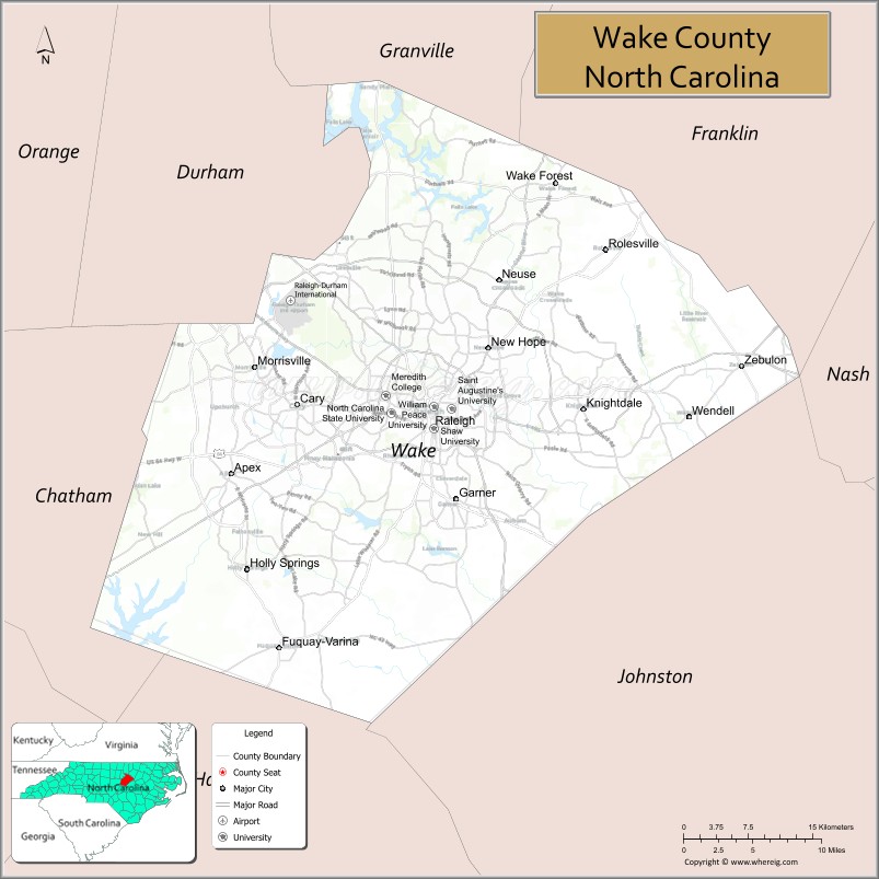
About Wake County Map, North Carolina: The map showing the county boundary, county seat, major cities, highways, water bodies and neighbouring counties.
Related North Carolina Links
About Wake County, North Carolina
Wake County is a county located in the U.S. state of North Carolina. It's county seat is Raleigh. As per 2020 census, the population of Wake County is 1150204 people and population density is square miles. According to the United States Census Bureau, the county has a total area of 857 sq mi (2,220 km2). Wake County was established on 1771.
Wake County Facts
| Continent | North America |
| Country | United States |
| State | North Carolina |
| County Seat | Raleigh |
| Largest City/Town | Raleigh |
| Established | 1771 |
| Total Area | 857 sq mi (2,219 sq km) |
| Land Area | 835 sq mi (2,163 sq km) |
| Water Area | 22 sq mi (56 sq km) |
| Population | 1,129,410 (Census 2020) |
| Population Density | 1,353 people per sq mi |
| Time Zone | Eastern Time Zone (ET) |
| Major Highways | I-40, I-440, I-540, US-1, US-64, US-70 |
| Major Rivers | Neuse River |
| Neighboring Counties | Durham County, Franklin County, Granville County, Harnett County, Johnston County, Nash County, Chatham County |
| Famous For | Raleigh (state capital), Research Triangle, universities, tech industry |
| Top Attractions | North Carolina Museum of Natural Sciences, Pullen Park, William B. Umstead State Park, North Carolina State Capitol |
| Official Website | Official Website |
About Wake County, North Carolina
Wake County is located in the central part of North Carolina, in the state of the United States, and was established in 1771. The county seat is Raleigh, which is also the largest city and the state capital. The county lies in the Piedmont region and is part of the Research Triangle, known for its strong economy, major universities, and rapidly growing technology sector.
Cities and Towns in Wake County, North Carolina
| City/Town | Population (Census 2020) | Latitude & Longitude |
|---|---|---|
| Raleigh (county seat) | 467,665 | 35.7796°N, 78.6382°W |
| Cary | 174,721 | 35.7915°N, 78.7811°W |
| Apex | 58,780 | 35.7327°N, 78.8503°W |
| Wake Forest | 47,601 | 35.9799°N, 78.5097°W |
| Holly Springs | 41,239 | 35.6513°N, 78.8336°W |
| Morrisville | 29,630 | 35.8235°N, 78.8256°W |
| Garner | 31,159 | 35.7113°N, 78.6142°W |
| Zebulon | 6,903 | 35.8243°N, 78.3144°W |
| Knightdale | 19,435 | 35.7876°N, 78.4803°W |
| Rolesville | 9,475 | 35.9238°N, 78.4564°W |
| Wendell | 9,553 | 35.7807°N, 78.3692°W |
Golf Courses in Wake County, North Carolina
| Golf Course | Location | Latitude & Longitude |
|---|---|---|
| Lonnie Poole Golf Course | Raleigh | 35.7800°N, 78.6700°W |
| Prestonwood Country Club | Cary | 35.8000°N, 78.8000°W |
| Eagle Ridge Golf Club | Raleigh | 35.6800°N, 78.6900°W |
Roads and Highways in Wake County, North Carolina
Wake County is a major transportation hub with extensive highway networks.
- I-40 – major interstate connecting Raleigh to Durham and Wilmington
- I-440 – beltline around Raleigh
- I-540 – outer loop around the Raleigh area
- US-1 – connects Raleigh to southern and northern regions
- US-64 – runs east–west through the county
- US-70 – provides regional connectivity
Neighboring Counties of Wake County
- Durham County (west)
- Granville County (north)
- Franklin County (northeast)
- Nash County (east)
- Johnston County (southeast)
- Harnett County (south)
- Chatham County (southwest)
Top Attractions in Wake County, North Carolina
The county offers museums, parks, and urban attractions.
- North Carolina Museum of Natural Sciences – largest natural history museum in the Southeast
- Pullen Park – historic park with rides and green space
- William B. Umstead State Park – hiking, biking, and nature trails
- North Carolina State Capitol – historic government building
- North Carolina Museum of Art – art collections and outdoor park
- Downtown Raleigh – dining, shopping, and entertainment
Distance from Wake County to Nearby Cities
- Raleigh to Durham – 25 mi (40 km)
- Raleigh to Greensboro – 75 mi (121 km)
- Raleigh to Charlotte – 170 mi (274 km)
- Raleigh to Wilmington – 130 mi (209 km)
- Raleigh to Richmond, VA – 160 mi (257 km)
FAQs about Wake County
Wake County is located in central North Carolina and includes the state capital, Raleigh.
The population of Wake County is 1,129,410 according to the 2020 Census.
Wake County is known for Raleigh, the Research Triangle, universities, and its technology industry.
Major highways include I-40, I-440, I-540, US-1, US-64, and US-70.
Yes, Wake County has several golf courses including Lonnie Poole Golf Course, Prestonwood Country Club, and Eagle Ridge Golf Club.
- Alamance County Map
- Alexander County Map
- Alleghany County Map
- Anson County Map
- Ashe County Map
- Avery County Map
- Beaufort County Map
- Bertie County Map
- Bladen County Map
- Brunswick County Map
- Buncombe County Map
- Burke County Map
- Cabarrus County Map
- Caldwell County Map
- Camden County Map
- Carteret County Map
- Caswell County Map
- Catawba County Map
- Chatham County Map
- Cherokee County Map
- Chowan County Map
- Clay County Map
- Cleveland County Map
- Columbus County Map
- Craven County Map
- Cumberland County Map
- Currituck County Map
- Dare County Map
- Davidson County Map
- Davie County Map
- Duplin County Map
- Durham County Map
- Edgecombe County Map
- Forsyth County Map
- Franklin County Map
- Gaston County Map
- Gates County Map
- Graham County Map
- Granville County Map
- Greene County Map
- Guilford County Map
- Halifax County Map
- Harnett County Map
- Haywood County Map
- Henderson County Map
- Hertford County Map
- Hoke County Map
- Hyde County Map
- Iredell County Map
- Jackson County Map
- Johnston County Map
- Jones County Map
- Lee County Map
- Lenoir County Map
- Lincoln County Map
- McDowell County Map
- Macon County Map
- Madison County Map
- Martin County Map
- Mecklenburg County Map
- Mitchell County Map
- Montgomery County Map
- Moore County Map
- Nash County Map
- New Hanover County Map
- Northampton County Map
- Onslow County Map
- Orange County Map
- Pamlico County Map
- Pasquotank County Map
- Pender County Map
- Perquimans County Map
- Person County Map
- Pitt County Map
- Polk County Map
- Randolph County Map
- Richmond County Map
- Robeson County Map
- Rockingham County Map
- Rowan County Map
- Rutherford County Map
- Sampson County Map
- Scotland County Map
- Stanly County Map
- Stokes County Map
- Surry County Map
- Swain County Map
- Transylvania County Map
- Tyrrell County Map
- Union County Map
- Vance County Map
- Wake County Map
- Warren County Map
- Washington County Map
- Watauga County Map
- Wayne County Map
- Wilkes County Map
- Wilson County Map
- Yadkin County Map
- Yancey County Map
- Alabama Counties
- Alaska boroughs
- Arizona Counties
- Arkansas Counties
- California County Map
- Colorado Counties
- Connecticut Counties
- Delaware Counties
- Florida County Map
- Georgia County Map
- Hawaii Counties
- Idaho Counties
- Illinois Counties
- Indiana Counties
- Iowa Counties
- Kansas Counties
- Kentucky Counties
- Louisiana Counties
- Maine Counties
- Maryland Counties
- Massachusetts Counties
- Michigan County Map
- Minnesota Counties
- Mississippi Counties
- Missouri Counties
- Montana Counties
- Nebraska Counties
- Nevada Counties
- New York Counties
- New Hampshire Counties
- New Jersey Counties
- New Mexico Counties
- North Carolina Counties
- North Dakota Counties
- Ohio County Map
- Oklahoma Counties
- Oregon Counties
- Pennsylvania Counties
- Rhode Island Counties
- South Carolina Counties
- South Dakota Counties
- Map of Tennessee
- Texas County Map
- Utah Counties
- Vermont Counties
- Virginia Counties
- Washington Counties
- West Virginia Counties
- Wisconsin Counties
- Wyoming Counties