Map of Currituck County - Currituck County is a county located in the U.S. state of North Carolina. Currituck County Map showing cities, highways, important places and water bodies. Get Where is Currituck County located in the map, major cities in Currituck county, population, areas, and places of interest.
Map of Currituck County, North Carolina
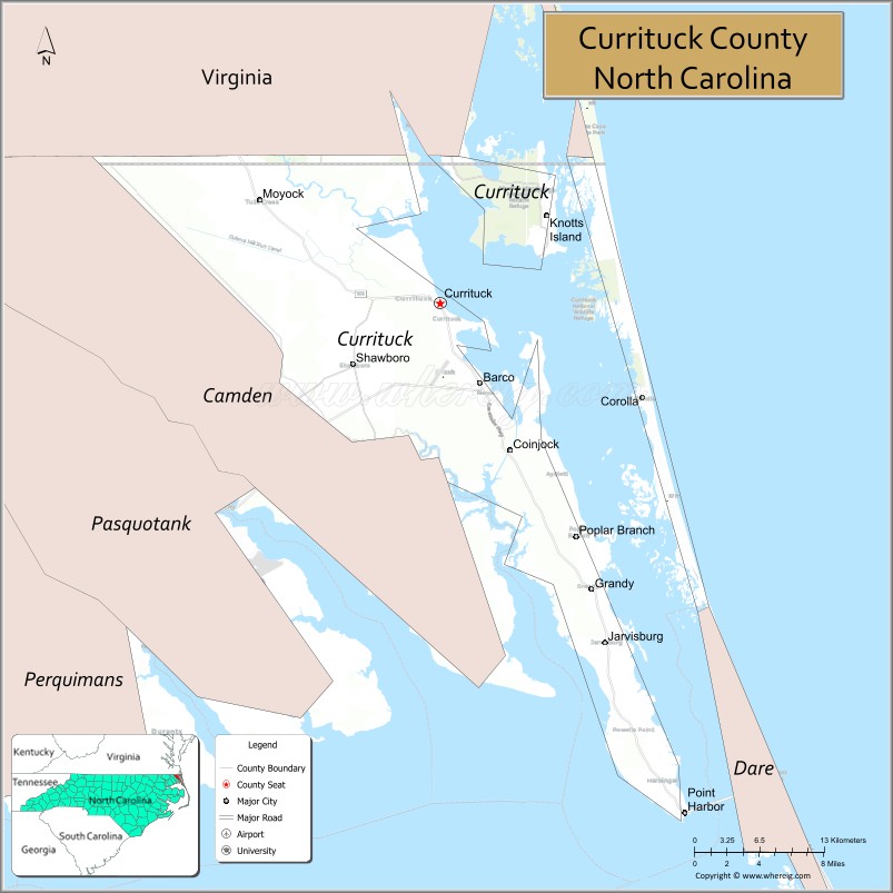
About Currituck County Map, North Carolina: The map showing the county boundary, county seat, major cities, highways, water bodies and neighbouring counties.
Related North Carolina Links
About Currituck County, North Carolina
Currituck County is a county located in the U.S. state of North Carolina. It's county seat is Currituck. As per 2020 census, the population of Currituck County is 29653 people and population density is square miles. According to the United States Census Bureau, the county has a total area of 526 sq mi (1,362 km2). Currituck County was established on 1668.
Currituck County Facts
| Continent | North America |
| Country | United States |
| State | North Carolina |
| County Seat | Currituck |
| Largest City/Town | Moyock |
| Established | 1668 |
| Total Area | 527 sq mi (1,365 sq km) |
| Land Area | 261 sq mi (676 sq km) |
| Water Area | 266 sq mi (689 sq km) |
| Population | 28,100 (Census 2020) |
| Population Density | 108 people per sq mi |
| Time Zone | Eastern Time Zone (ET) |
| Major Highways | US-158, NC-168, NC-12 |
| Major Rivers | Currituck Sound, North River |
| Neighboring Counties | Camden County, Dare County, Chesapeake (VA), Virginia Beach (VA) |
| Famous For | Outer Banks access, wild horses, beaches, Currituck Sound |
| Top Attractions | Currituck Beach Lighthouse, Corolla Wild Horses, Whalehead Club, Outer Banks beaches |
| Official Website | Official Website |
About Currituck County, North Carolina
Currituck County is located in the northeastern part of North Carolina, in the state of the United States, and was established in 1668. The county seat is Currituck, while Moyock is the largest community. The county stretches from the mainland to the Outer Banks and is known for its coastal landscapes, beaches, and famous wild horses of Corolla.
Cities and Towns in Currituck County, North Carolina
| City/Town | Population (Census 2020) | Latitude & Longitude |
|---|---|---|
| Currituck (county seat) | 900 | 36.4400°N, 76.0000°W |
| Moyock | 5,759 | 36.5200°N, 76.1800°W |
| Corolla (CDP) | 500 | 36.3800°N, 75.8300°W |
| Coinjock (CDP) | 300 | 36.3400°N, 75.9400°W |
| Grandy (CDP) | 1,700 | 36.2200°N, 75.8700°W |
| Poplar Branch (CDP) | 400 | 36.3000°N, 75.8800°W |
| Shawboro (CDP) | 400 | 36.3600°N, 75.9700°W |
| Jarvisburg (CDP) | 500 | 36.2100°N, 75.8600°W |
Golf Courses in Currituck County, North Carolina
| Golf Course | Location | Latitude & Longitude |
|---|---|---|
| The Currituck Club | Corolla | 36.3700°N, 75.8300°W |
| Carolina Club Golf Links | Grandy | 36.2300°N, 75.8700°W |
Roads and Highways in Currituck County, North Carolina
Currituck County is connected by coastal and inland highways linking it to Virginia and the Outer Banks.
- US-158 – major route connecting the county to Elizabeth City and the Outer Banks
- NC-168 – connects Moyock to the Virginia border and Chesapeake
- NC-12 – scenic coastal highway running along the Outer Banks
Neighboring Counties of Currituck County
- Camden County (southwest)
- Dare County (south)
- City of Chesapeake, Virginia (north)
- City of Virginia Beach, Virginia (north)
Top Attractions in Currituck County, North Carolina
The county is a major destination for coastal tourism and outdoor recreation.
- Currituck Beach Lighthouse – historic lighthouse with panoramic views
- Corolla Wild Horses – famous herd of wild Spanish mustangs roaming the beaches
- Whalehead Club – restored historic mansion in Corolla
- Outer Banks beaches – popular for swimming, fishing, and relaxation
- Currituck Sound – scenic waterway for boating and wildlife viewing
- Historic Corolla Park – area with walking paths and cultural attractions
Distance from Currituck County to Nearby Cities
- Moyock to Norfolk, VA – 25 mi (40 km)
- Moyock to Virginia Beach, VA – 35 mi (56 km)
- Moyock to Elizabeth City – 30 mi (48 km)
- Moyock to Outer Banks – 40 mi (64 km)
- Moyock to Raleigh – 190 mi (306 km)
FAQs about Currituck County
Currituck County is located in northeastern North Carolina, stretching from the mainland to the Outer Banks.
The population of Currituck County is 28,100 according to the 2020 Census.
Currituck County is known for its beaches, Outer Banks access, and wild horses of Corolla.
Major highways include US-158, NC-168, and NC-12.
Yes, Currituck County has golf courses including The Currituck Club and Carolina Club Golf Links.
- Alamance County Map
- Alexander County Map
- Alleghany County Map
- Anson County Map
- Ashe County Map
- Avery County Map
- Beaufort County Map
- Bertie County Map
- Bladen County Map
- Brunswick County Map
- Buncombe County Map
- Burke County Map
- Cabarrus County Map
- Caldwell County Map
- Camden County Map
- Carteret County Map
- Caswell County Map
- Catawba County Map
- Chatham County Map
- Cherokee County Map
- Chowan County Map
- Clay County Map
- Cleveland County Map
- Columbus County Map
- Craven County Map
- Cumberland County Map
- Currituck County Map
- Dare County Map
- Davidson County Map
- Davie County Map
- Duplin County Map
- Durham County Map
- Edgecombe County Map
- Forsyth County Map
- Franklin County Map
- Gaston County Map
- Gates County Map
- Graham County Map
- Granville County Map
- Greene County Map
- Guilford County Map
- Halifax County Map
- Harnett County Map
- Haywood County Map
- Henderson County Map
- Hertford County Map
- Hoke County Map
- Hyde County Map
- Iredell County Map
- Jackson County Map
- Johnston County Map
- Jones County Map
- Lee County Map
- Lenoir County Map
- Lincoln County Map
- McDowell County Map
- Macon County Map
- Madison County Map
- Martin County Map
- Mecklenburg County Map
- Mitchell County Map
- Montgomery County Map
- Moore County Map
- Nash County Map
- New Hanover County Map
- Northampton County Map
- Onslow County Map
- Orange County Map
- Pamlico County Map
- Pasquotank County Map
- Pender County Map
- Perquimans County Map
- Person County Map
- Pitt County Map
- Polk County Map
- Randolph County Map
- Richmond County Map
- Robeson County Map
- Rockingham County Map
- Rowan County Map
- Rutherford County Map
- Sampson County Map
- Scotland County Map
- Stanly County Map
- Stokes County Map
- Surry County Map
- Swain County Map
- Transylvania County Map
- Tyrrell County Map
- Union County Map
- Vance County Map
- Wake County Map
- Warren County Map
- Washington County Map
- Watauga County Map
- Wayne County Map
- Wilkes County Map
- Wilson County Map
- Yadkin County Map
- Yancey County Map
- Alabama Counties
- Alaska boroughs
- Arizona Counties
- Arkansas Counties
- California County Map
- Colorado Counties
- Connecticut Counties
- Delaware Counties
- Florida County Map
- Georgia County Map
- Hawaii Counties
- Idaho Counties
- Illinois Counties
- Indiana Counties
- Iowa Counties
- Kansas Counties
- Kentucky Counties
- Louisiana Counties
- Maine Counties
- Maryland Counties
- Massachusetts Counties
- Michigan County Map
- Minnesota Counties
- Mississippi Counties
- Missouri Counties
- Montana Counties
- Nebraska Counties
- Nevada Counties
- New York Counties
- New Hampshire Counties
- New Jersey Counties
- New Mexico Counties
- North Carolina Counties
- North Dakota Counties
- Ohio County Map
- Oklahoma Counties
- Oregon Counties
- Pennsylvania Counties
- Rhode Island Counties
- South Carolina Counties
- South Dakota Counties
- Map of Tennessee
- Texas County Map
- Utah Counties
- Vermont Counties
- Virginia Counties
- Washington Counties
- West Virginia Counties
- Wisconsin Counties
- Wyoming Counties