Map of Moore County - Moore County is a county located in the U.S. state of North Carolina. Moore County Map showing cities, highways, important places and water bodies. Get Where is Moore County located in the map, major cities in Moore county, population, areas, and places of interest.
Map of Moore County, North Carolina
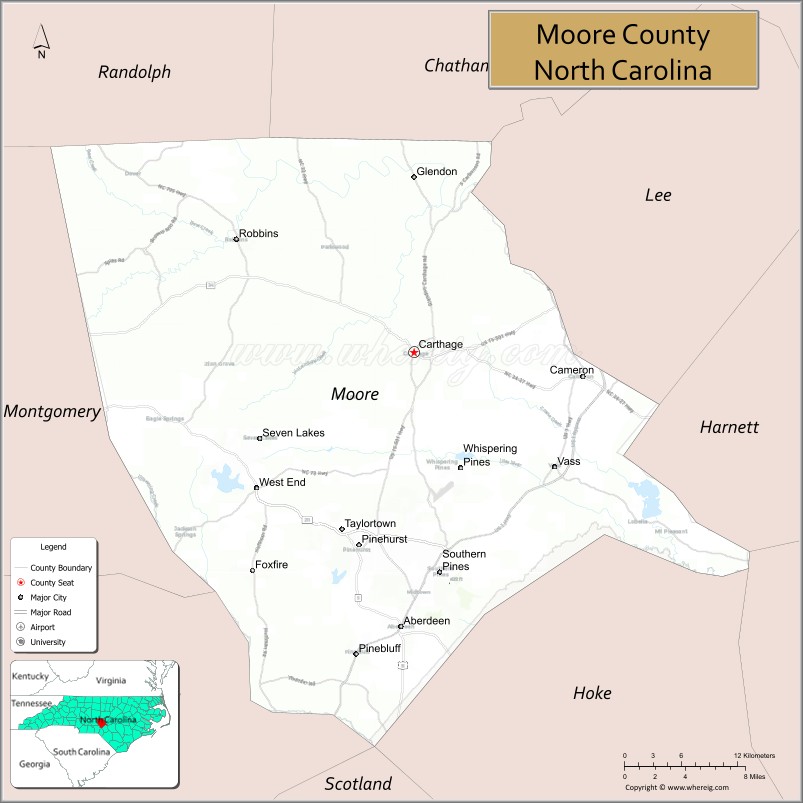
About Moore County Map, North Carolina: The map showing the county boundary, county seat, major cities, highways, water bodies and neighbouring counties.
Related North Carolina Links
About Moore County, North Carolina
Moore County is a county located in the U.S. state of North Carolina. It's county seat is Carthage. As per 2020 census, the population of Moore County is 102763 people and population density is square miles. According to the United States Census Bureau, the county has a total area of 706 sq mi (1,829 km2). Moore County was established on 1784.
Moore County Facts
| Continent | North America |
| Country | United States |
| State | North Carolina |
| County Seat | Carthage |
| Largest City/Town | Pinehurst |
| Established | 1785 |
| Total Area | 706 sq mi (1,829 sq km) |
| Land Area | 697 sq mi (1,805 sq km) |
| Water Area | 9 sq mi (24 sq km) |
| Population | 99,727 (Census 2020) |
| Population Density | 143 people per sq mi |
| Time Zone | Eastern Time Zone (ET) |
| Major Highways | US-1, US-15/501, NC-5, NC-22, NC-211 |
| Major Rivers | Little River, Deep River |
| Neighboring Counties | Lee County, Chatham County, Randolph County, Montgomery County, Richmond County, Scotland County, Hoke County |
| Famous For | Golf resorts, Pinehurst, Sandhills region |
| Top Attractions | Pinehurst Resort, Southern Pines, Weymouth Woods, Sandhills Horticultural Gardens |
| Official Website | Official Website |
About Moore County, North Carolina
Moore County is located in the south-central part of North Carolina, in the state of the United States, and was established in 1785. The county seat is Carthage, while Pinehurst is the largest and most well-known community. The county lies within the Sandhills region and is internationally recognized for its golf courses, resorts, and scenic landscapes.
Cities and Towns in Moore County, North Carolina
| City/Town | Population (Census 2020) | Latitude & Longitude |
|---|---|---|
| Pinehurst | 17,581 | 35.1954°N, 79.4695°W |
| Southern Pines | 15,545 | 35.1740°N, 79.3922°W |
| Carthage (county seat) | 2,750 | 35.3457°N, 79.4167°W |
| Aberdeen | 8,500 | 35.1316°N, 79.4295°W |
| Cameron | 400 | 35.3270°N, 79.2514°W |
| Vass | 800 | 35.2600°N, 79.2800°W |
| Whispering Pines | 4,000 | 35.2500°N, 79.3700°W |
Golf Courses in Moore County, North Carolina
| Golf Course | Location | Latitude & Longitude |
|---|---|---|
| Pinehurst No. 2 | Pinehurst | 35.2000°N, 79.4700°W |
| Mid Pines Golf Club | Southern Pines | 35.1800°N, 79.4000°W |
| Pine Needles Lodge & Golf Club | Southern Pines | 35.1800°N, 79.3900°W |
Roads and Highways in Moore County, North Carolina
Moore County is connected by highways serving the Sandhills region and surrounding areas.
- US-1 – major north–south route connecting the county to Raleigh and South Carolina
- US-15/501 – connects the county to Sanford and Laurinburg
- NC-5 – runs through Pinehurst and Southern Pines
- NC-22 – provides regional connections
- NC-211 – links the county to other Sandhills communities
Neighboring Counties of Moore County
- Chatham County (north)
- Lee County (northwest)
- Randolph County (northwest)
- Montgomery County (west)
- Richmond County (south)
- Scotland County (south)
- Hoke County (east)
Top Attractions in Moore County, North Carolina
The county is a premier destination for golf and outdoor recreation.
- Pinehurst Resort – world-renowned golf destination
- Southern Pines – charming town with shops and restaurants
- Weymouth Woods Sandhills Nature Preserve – hiking and longleaf pine forests
- Sandhills Horticultural Gardens – botanical gardens and educational center
- Downtown Aberdeen – historic district with local businesses
- Reservoir Park – outdoor recreation and walking trails
Distance from Moore County to Nearby Cities
- Pinehurst to Raleigh – 70 mi (113 km)
- Pinehurst to Fayetteville – 40 mi (64 km)
- Pinehurst to Charlotte – 90 mi (145 km)
- Pinehurst to Greensboro – 80 mi (129 km)
- Pinehurst to Wilmington – 120 mi (193 km)
FAQs about Moore County
Moore County is located in south-central North Carolina in the Sandhills region.
The population of Moore County is 99,727 according to the 2020 Census.
Moore County is known for its world-class golf courses, especially in Pinehurst.
Major highways include US-1, US-15/501, NC-5, NC-22, and NC-211.
Yes, Moore County is famous for its golf courses, including Pinehurst No. 2 and Pine Needles Golf Club.
- Alamance County Map
- Alexander County Map
- Alleghany County Map
- Anson County Map
- Ashe County Map
- Avery County Map
- Beaufort County Map
- Bertie County Map
- Bladen County Map
- Brunswick County Map
- Buncombe County Map
- Burke County Map
- Cabarrus County Map
- Caldwell County Map
- Camden County Map
- Carteret County Map
- Caswell County Map
- Catawba County Map
- Chatham County Map
- Cherokee County Map
- Chowan County Map
- Clay County Map
- Cleveland County Map
- Columbus County Map
- Craven County Map
- Cumberland County Map
- Currituck County Map
- Dare County Map
- Davidson County Map
- Davie County Map
- Duplin County Map
- Durham County Map
- Edgecombe County Map
- Forsyth County Map
- Franklin County Map
- Gaston County Map
- Gates County Map
- Graham County Map
- Granville County Map
- Greene County Map
- Guilford County Map
- Halifax County Map
- Harnett County Map
- Haywood County Map
- Henderson County Map
- Hertford County Map
- Hoke County Map
- Hyde County Map
- Iredell County Map
- Jackson County Map
- Johnston County Map
- Jones County Map
- Lee County Map
- Lenoir County Map
- Lincoln County Map
- McDowell County Map
- Macon County Map
- Madison County Map
- Martin County Map
- Mecklenburg County Map
- Mitchell County Map
- Montgomery County Map
- Moore County Map
- Nash County Map
- New Hanover County Map
- Northampton County Map
- Onslow County Map
- Orange County Map
- Pamlico County Map
- Pasquotank County Map
- Pender County Map
- Perquimans County Map
- Person County Map
- Pitt County Map
- Polk County Map
- Randolph County Map
- Richmond County Map
- Robeson County Map
- Rockingham County Map
- Rowan County Map
- Rutherford County Map
- Sampson County Map
- Scotland County Map
- Stanly County Map
- Stokes County Map
- Surry County Map
- Swain County Map
- Transylvania County Map
- Tyrrell County Map
- Union County Map
- Vance County Map
- Wake County Map
- Warren County Map
- Washington County Map
- Watauga County Map
- Wayne County Map
- Wilkes County Map
- Wilson County Map
- Yadkin County Map
- Yancey County Map
- Alabama Counties
- Alaska boroughs
- Arizona Counties
- Arkansas Counties
- California County Map
- Colorado Counties
- Connecticut Counties
- Delaware Counties
- Florida County Map
- Georgia County Map
- Hawaii Counties
- Idaho Counties
- Illinois Counties
- Indiana Counties
- Iowa Counties
- Kansas Counties
- Kentucky Counties
- Louisiana Counties
- Maine Counties
- Maryland Counties
- Massachusetts Counties
- Michigan County Map
- Minnesota Counties
- Mississippi Counties
- Missouri Counties
- Montana Counties
- Nebraska Counties
- Nevada Counties
- New York Counties
- New Hampshire Counties
- New Jersey Counties
- New Mexico Counties
- North Carolina Counties
- North Dakota Counties
- Ohio County Map
- Oklahoma Counties
- Oregon Counties
- Pennsylvania Counties
- Rhode Island Counties
- South Carolina Counties
- South Dakota Counties
- Map of Tennessee
- Texas County Map
- Utah Counties
- Vermont Counties
- Virginia Counties
- Washington Counties
- West Virginia Counties
- Wisconsin Counties
- Wyoming Counties