Map of Polk County - Polk County is a county located in the U.S. state of North Carolina. Polk County Map showing cities, highways, important places and water bodies. Get Where is Polk County located in the map, major cities in Polk county, population, areas, and places of interest.
Map of Polk County, North Carolina
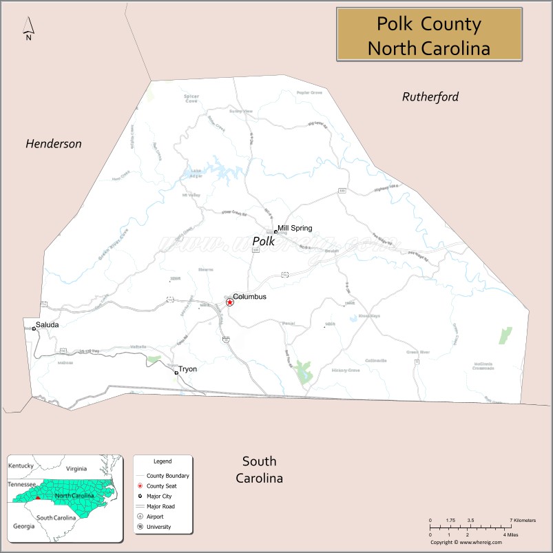
About Polk County Map, North Carolina: The map showing the county boundary, county seat, major cities, highways, water bodies and neighbouring counties.
Most Viewed NC Maps & Info
About Polk County, North Carolina
Polk County is a county located in the U.S. state of North Carolina. It's county seat is Columbus. As per 2020 census, the population of Polk County is 19656 people and population density is square miles. According to the United States Census Bureau, the county has a total area of 239 sq mi (619 km2). Polk County was established on 1855.
Facts about Polk County, North Carolina
| Country | United States |
| State | North Carolina |
| Region | Western NC / Foothills of the Blue Ridge Mountains |
| County Seat | Columbus |
| Named After | Colonel William Polk |
| Established | 1855 |
| Coordinates | ~35.24° N, 82.27° W |
| Total Area | ~238.6 sq mi |
| Land Area | ~237.8 sq mi |
| Water Area | ~0.8 sq mi |
| Population (2020) | ~19,328 |
| Estimated Population (2025) | ~20,610 |
| Population Rank (NC) | Small county in NC |
| Largest Town | Tryon |
| Main Towns & Communities | Columbus, Tryon, Saluda, Mill Spring |
| Main Industries | Agriculture, Tourism, Small Business, Equestrian & Outdoor Recreation |
| Major Geographic Features | Green River, Lake Adger, foothills & thermal belt region |
| Time Zone | Eastern Time (UTC−05:00 / −04:00 DST) |
| Known For | Equestrian events (Tryon International Equestrian Center), scenic mountain landscapes, small‑town charm |
| Website | https://www.polknc.gov |
Top Attractions in Polk County, North Carolina
- Pearson’s Falls – Scenic waterfall and hiking trails.
- Chimney Rock State Park – Rock formations and panoramic views.
- Lake Lure – Boating, swimming, and lakeside recreation.
- Historic Downtown Tryon – Shops, galleries, and dining.
- Tryon International Equestrian Center – Horse shows and events.
- Burntshirt Vineyards – Wine tasting and tours.
- Glen Cannon Country Club – Golf and leisure.
- Isothermal Community College Arboretum – Gardens and walking paths.
- Hendersonville Scenic Overlook – Mountain views nearby.
- Lake Lure Flowering Bridge – Gardens and pedestrian bridge.
Cities & Towns in Polk County, North Carolina
Tryon, Columbus, Saluda, Mill Spring, Mill Spring
- Alamance County Map
- Alexander County Map
- Alleghany County Map
- Anson County Map
- Ashe County Map
- Avery County Map
- Beaufort County Map
- Bertie County Map
- Bladen County Map
- Brunswick County Map
- Buncombe County Map
- Burke County Map
- Cabarrus County Map
- Caldwell County Map
- Camden County Map
- Carteret County Map
- Caswell County Map
- Catawba County Map
- Chatham County Map
- Cherokee County Map
- Chowan County Map
- Clay County Map
- Cleveland County Map
- Columbus County Map
- Craven County Map
- Cumberland County Map
- Currituck County Map
- Dare County Map
- Davidson County Map
- Davie County Map
- Duplin County Map
- Durham County Map
- Edgecombe County Map
- Forsyth County Map
- Franklin County Map
- Gaston County Map
- Gates County Map
- Graham County Map
- Granville County Map
- Greene County Map
- Guilford County Map
- Halifax County Map
- Harnett County Map
- Haywood County Map
- Henderson County Map
- Hertford County Map
- Hoke County Map
- Hyde County Map
- Iredell County Map
- Jackson County Map
- Johnston County Map
- Jones County Map
- Lee County Map
- Lenoir County Map
- Lincoln County Map
- McDowell County Map
- Macon County Map
- Madison County Map
- Martin County Map
- Mecklenburg County Map
- Mitchell County Map
- Montgomery County Map
- Moore County Map
- Nash County Map
- New Hanover County Map
- Northampton County Map
- Onslow County Map
- Orange County Map
- Pamlico County Map
- Pasquotank County Map
- Pender County Map
- Perquimans County Map
- Person County Map
- Pitt County Map
- Polk County Map
- Randolph County Map
- Richmond County Map
- Robeson County Map
- Rockingham County Map
- Rowan County Map
- Rutherford County Map
- Sampson County Map
- Scotland County Map
- Stanly County Map
- Stokes County Map
- Surry County Map
- Swain County Map
- Transylvania County Map
- Tyrrell County Map
- Union County Map
- Vance County Map
- Wake County Map
- Warren County Map
- Washington County Map
- Watauga County Map
- Wayne County Map
- Wilkes County Map
- Wilson County Map
- Yadkin County Map
- Yancey County Map
- Alabama Counties
- Alaska boroughs
- Arizona Counties
- Arkansas Counties
- California County Map
- Colorado Counties
- Connecticut Counties
- Delaware Counties
- Florida County Map
- Georgia County Map
- Hawaii Counties
- Idaho Counties
- Illinois Counties
- Indiana Counties
- Iowa Counties
- Kansas Counties
- Kentucky Counties
- Louisiana Counties
- Maine Counties
- Maryland Counties
- Massachusetts Counties
- Michigan County Map
- Minnesota Counties
- Mississippi Counties
- Missouri Counties
- Montana Counties
- Nebraska Counties
- New Hampshire Counties
- New Jersey Counties
- New Mexico Counties
- North Carolina Counties
- North Dakota Counties
- Oklahoma Counties
- Oregon Counties
- Pennsylvania Counties
- Rhode Island Counties
- South Carolina Counties
- South Dakota Counties
- Map of Tennessee
- Texas County Map
- Utah Counties
- Vermont Counties
- Virginia Counties
- Washington Counties
- West Virginia Counties
- Wisconsin Counties
- Wyoming Counties
- Nevada Counties
- New York Counties
- Ohio County Map