Map of Cumberland County - Cumberland County is a county located in the U.S. state of North Carolina. Cumberland County Map showing cities, highways, important places and water bodies. Get Where is Cumberland County located in the map, major cities in Cumberland county, population, areas, and places of interest.
Map of Cumberland County, North Carolina
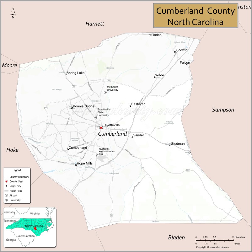
About Cumberland County Map, North Carolina: The map showing the county boundary, county seat, major cities, highways, water bodies and neighbouring counties.
Related North Carolina Links
About Cumberland County, North Carolina
Cumberland County is a county located in the U.S. state of North Carolina. It's county seat is Fayetteville. As per 2020 census, the population of Cumberland County is 335508 people and population density is square miles. According to the United States Census Bureau, the county has a total area of 658 sq mi (1,704 km2). Cumberland County was established on 1754.
Cumberland County Facts
| Continent | North America |
| Country | United States |
| State | North Carolina |
| County Seat | Fayetteville |
| Largest City/Town | Fayetteville |
| Established | 1754 |
| Total Area | 658 sq mi (1,704 sq km) |
| Land Area | 652 sq mi (1,688 sq km) |
| Water Area | 6 sq mi (16 sq km) |
| Population | 335,508 (Census 2020) |
| Population Density | 515 people per sq mi |
| Time Zone | Eastern Time Zone (ET) |
| Major Highways | I-95, US-401, US-301, US-13, NC-24, NC-87 |
| Major Rivers | Cape Fear River, Little River |
| Neighboring Counties | Harnett County, Sampson County, Bladen County, Robeson County, Hoke County, Moore County |
| Famous For | Fort Liberty (Fort Bragg), military presence, Fayetteville, Cape Fear River |
| Top Attractions | Airborne & Special Operations Museum, Cape Fear Botanical Garden, Festival Park, Crown Complex |
| Official Website | Official Website |
About Cumberland County, North Carolina
Cumberland County is located in the southeastern part of North Carolina, in the state of the United States, and was established in 1754. The county seat is Fayetteville, which is also the largest city. The county lies along the Cape Fear River and is known for its strong military presence due to Fort Liberty, as well as its historical and cultural significance.
Cities and Towns in Cumberland County, North Carolina
| City/Town | Population (Census 2020) | Latitude & Longitude |
|---|---|---|
| Fayetteville (county seat) | 208,501 | 35.0527°N, 78.8784°W |
| Hope Mills | 16,417 | 34.9704°N, 78.9456°W |
| Spring Lake | 11,684 | 35.1671°N, 78.9728°W |
| Eastover | 3,776 | 35.0985°N, 78.7811°W |
| Falcon | 258 | 35.1907°N, 78.6508°W |
| Godwin | 101 | 35.1796°N, 78.6633°W |
| Linden | 130 | 35.2604°N, 78.7820°W |
| Stedman | 664 | 35.0132°N, 78.6947°W |
| Vander (CDP) | 13,000 | 35.0200°N, 78.7500°W |
Golf Courses in Cumberland County, North Carolina
| Golf Course | Location | Latitude & Longitude |
|---|---|---|
| Anderson Creek Golf Club | Spring Lake | 35.2000°N, 78.9500°W |
| Bayonet at Puppy Creek | Raeford (near county line) | 35.0500°N, 79.2000°W |
| King’s Grant Golf & Country Club | Fayetteville | 35.1000°N, 78.9000°W |
| Chicora Golf Club | Dunn area | 35.3000°N, 78.6000°W |
Roads and Highways in Cumberland County, North Carolina
Cumberland County is a major transportation hub in southeastern North Carolina.
- I-95 – major north–south interstate connecting the county to Virginia and South Carolina
- US-401 – links Fayetteville to Raleigh and Laurinburg
- US-301 – runs parallel to I-95 through the county
- US-13 – connects Fayetteville to eastern North Carolina
- NC-24 – runs east–west connecting Fayetteville to Jacksonville
- NC-87 – connects the county to Sanford and Wilmington
Neighboring Counties of Cumberland County
- Harnett County (north)
- Sampson County (east)
- Bladen County (southeast)
- Robeson County (south)
- Hoke County (west)
- Moore County (northwest)
Top Attractions in Cumberland County, North Carolina
The county offers a mix of history, military heritage, and recreation.
- Airborne & Special Operations Museum – exhibits on military history and airborne forces
- Cape Fear Botanical Garden – scenic gardens with walking trails and events
- Festival Park – popular venue for community events and concerts
- Crown Complex – large entertainment and sports venue
- Fayetteville Downtown District – shops, dining, and historic sites
- Clark Park Nature Center – outdoor area with trails and environmental education
Distance from Cumberland County to Nearby Cities
- Fayetteville to Raleigh – 65 mi (105 km)
- Fayetteville to Charlotte – 130 mi (209 km)
- Fayetteville to Wilmington – 90 mi (145 km)
- Fayetteville to Columbia, SC – 120 mi (193 km)
- Fayetteville to Durham – 80 mi (129 km)
FAQs about Cumberland County
Cumberland County is located in southeastern North Carolina along the Cape Fear River.
The population of Cumberland County is 335,508 according to the 2020 Census.
Cumberland County is known for Fort Liberty, military history, and the city of Fayetteville.
Major highways include I-95, US-401, US-301, US-13, NC-24, and NC-87.
Yes, Cumberland County has golf courses including Anderson Creek Golf Club and King’s Grant Golf & Country Club.
- Alamance County Map
- Alexander County Map
- Alleghany County Map
- Anson County Map
- Ashe County Map
- Avery County Map
- Beaufort County Map
- Bertie County Map
- Bladen County Map
- Brunswick County Map
- Buncombe County Map
- Burke County Map
- Cabarrus County Map
- Caldwell County Map
- Camden County Map
- Carteret County Map
- Caswell County Map
- Catawba County Map
- Chatham County Map
- Cherokee County Map
- Chowan County Map
- Clay County Map
- Cleveland County Map
- Columbus County Map
- Craven County Map
- Cumberland County Map
- Currituck County Map
- Dare County Map
- Davidson County Map
- Davie County Map
- Duplin County Map
- Durham County Map
- Edgecombe County Map
- Forsyth County Map
- Franklin County Map
- Gaston County Map
- Gates County Map
- Graham County Map
- Granville County Map
- Greene County Map
- Guilford County Map
- Halifax County Map
- Harnett County Map
- Haywood County Map
- Henderson County Map
- Hertford County Map
- Hoke County Map
- Hyde County Map
- Iredell County Map
- Jackson County Map
- Johnston County Map
- Jones County Map
- Lee County Map
- Lenoir County Map
- Lincoln County Map
- McDowell County Map
- Macon County Map
- Madison County Map
- Martin County Map
- Mecklenburg County Map
- Mitchell County Map
- Montgomery County Map
- Moore County Map
- Nash County Map
- New Hanover County Map
- Northampton County Map
- Onslow County Map
- Orange County Map
- Pamlico County Map
- Pasquotank County Map
- Pender County Map
- Perquimans County Map
- Person County Map
- Pitt County Map
- Polk County Map
- Randolph County Map
- Richmond County Map
- Robeson County Map
- Rockingham County Map
- Rowan County Map
- Rutherford County Map
- Sampson County Map
- Scotland County Map
- Stanly County Map
- Stokes County Map
- Surry County Map
- Swain County Map
- Transylvania County Map
- Tyrrell County Map
- Union County Map
- Vance County Map
- Wake County Map
- Warren County Map
- Washington County Map
- Watauga County Map
- Wayne County Map
- Wilkes County Map
- Wilson County Map
- Yadkin County Map
- Yancey County Map
- Alabama Counties
- Alaska boroughs
- Arizona Counties
- Arkansas Counties
- California County Map
- Colorado Counties
- Connecticut Counties
- Delaware Counties
- Florida County Map
- Georgia County Map
- Hawaii Counties
- Idaho Counties
- Illinois Counties
- Indiana Counties
- Iowa Counties
- Kansas Counties
- Kentucky Counties
- Louisiana Counties
- Maine Counties
- Maryland Counties
- Massachusetts Counties
- Michigan County Map
- Minnesota Counties
- Mississippi Counties
- Missouri Counties
- Montana Counties
- Nebraska Counties
- Nevada Counties
- New York Counties
- New Hampshire Counties
- New Jersey Counties
- New Mexico Counties
- North Carolina Counties
- North Dakota Counties
- Ohio County Map
- Oklahoma Counties
- Oregon Counties
- Pennsylvania Counties
- Rhode Island Counties
- South Carolina Counties
- South Dakota Counties
- Map of Tennessee
- Texas County Map
- Utah Counties
- Vermont Counties
- Virginia Counties
- Washington Counties
- West Virginia Counties
- Wisconsin Counties
- Wyoming Counties