Map of Nash County - Nash County is a county located in the U.S. state of North Carolina. Nash County Map showing cities, highways, important places and water bodies. Get Where is Nash County located in the map, major cities in Nash county, population, areas, and places of interest.
Map of Nash County, North Carolina
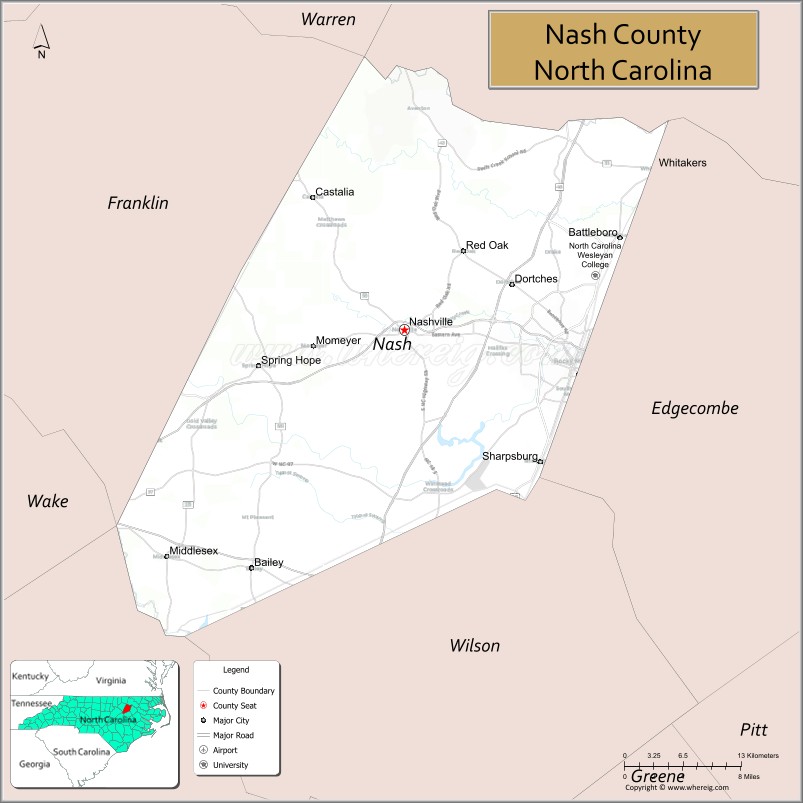
About Nash County Map, North Carolina: The map showing the county boundary, county seat, major cities, highways, water bodies and neighbouring counties.
Related North Carolina Links
About Nash County, North Carolina
Nash County is a county located in the U.S. state of North Carolina. It's county seat is Nashville. As per 2020 census, the population of Nash County is 95176 people and population density is square miles. According to the United States Census Bureau, the county has a total area of 543 sq mi (1,406 km2). Nash County was established on 1777.
Nash County Facts
| Continent | North America |
| Country | United States |
| State | North Carolina |
| County Seat | Nashville |
| Largest City/Town | Rocky Mount (partly in Edgecombe County) |
| Established | 1777 |
| Total Area | 542 sq mi (1,404 sq km) |
| Land Area | 540 sq mi (1,399 sq km) |
| Water Area | 2 sq mi (5 sq km) |
| Population | 94,970 (Census 2020) |
| Population Density | 176 people per sq mi |
| Time Zone | Eastern Time Zone (ET) |
| Major Highways | I-95, US-64, US-264, NC-97 |
| Major Rivers | Tar River |
| Neighboring Counties | Halifax County, Edgecombe County, Wilson County, Franklin County, Johnston County |
| Famous For | Rocky Mount, agriculture, I-95 corridor |
| Top Attractions | Rocky Mount Mills, Imperial Centre for the Arts, Sunset Park, Nash County Farmers Market |
| Official Website | Official Website |
About Nash County, North Carolina
Nash County is located in the eastern part of North Carolina, in the state of the United States, and was established in 1777. The county seat is Nashville, while Rocky Mount is the largest city partly within the county. The county lies within the coastal plain region and is known for its agricultural heritage, growing communities, and its role as a transportation hub along Interstate 95.
Cities and Towns in Nash County, North Carolina
| City/Town | Population (Census 2020) | Latitude & Longitude |
|---|---|---|
| Rocky Mount (partly in Edgecombe County) | 54,341 | 35.9382°N, 77.7905°W |
| Nashville (county seat) | 5,352 | 35.9743°N, 77.9650°W |
| Spring Hope | 1,300 | 35.9400°N, 78.1000°W |
| Middlesex | 900 | 35.7900°N, 78.2000°W |
| Castalia | 300 | 36.0700°N, 78.0700°W |
| Bailey | 600 | 35.7800°N, 78.1200°W |
| Dortches | 1,200 | 36.0300°N, 77.9000°W |
| Red Oak | 3,500 | 36.0400°N, 77.9000°W |
| Whitakers (partly in Edgecombe County) | 800 | 36.1000°N, 77.7100°W |
Golf Courses in Nash County, North Carolina
| Golf Course | Location | Latitude & Longitude |
|---|---|---|
| Benvenue Country Club | Rocky Mount | 35.9600°N, 77.8100°W |
| Belmont Lake Golf Club | Rocky Mount | 35.9200°N, 77.8200°W |
Roads and Highways in Nash County, North Carolina
Nash County is a major transportation corridor in eastern North Carolina.
- I-95 – major north–south interstate running through the county
- US-64 – connects the county to Raleigh and the Outer Banks
- US-264 – provides access to Greenville and Wilson
- NC-97 – connects local communities within the county
Neighboring Counties of Nash County
- Halifax County (north)
- Edgecombe County (east)
- Wilson County (south)
- Johnston County (southwest)
- Franklin County (west)
Top Attractions in Nash County, North Carolina
The county offers cultural attractions, outdoor recreation, and community events.
- Rocky Mount Mills – historic mill complex with breweries and restaurants
- Imperial Centre for the Arts & Sciences – museum and performing arts venue
- Sunset Park – local park with trails and recreational facilities
- Nash County Farmers Market – local produce and goods
- Tar River – fishing, kayaking, and scenic views
- Downtown Nashville – historic district with shops and dining
Distance from Nash County to Nearby Cities
- Rocky Mount to Raleigh – 60 mi (97 km)
- Rocky Mount to Greenville – 40 mi (64 km)
- Rocky Mount to Wilson – 20 mi (32 km)
- Rocky Mount to Durham – 80 mi (129 km)
- Rocky Mount to Norfolk, VA – 120 mi (193 km)
FAQs about Nash County
Nash County is located in eastern North Carolina along the I-95 corridor.
The population of Nash County is 94,970 according to the 2020 Census.
Nash County is known for Rocky Mount, agriculture, and its role as a transportation hub.
Major highways include I-95, US-64, US-264, and NC-97.
Yes, Nash County has golf courses including Belmont Lake Golf Club and Benvenue Country Club.
- Alamance County Map
- Alexander County Map
- Alleghany County Map
- Anson County Map
- Ashe County Map
- Avery County Map
- Beaufort County Map
- Bertie County Map
- Bladen County Map
- Brunswick County Map
- Buncombe County Map
- Burke County Map
- Cabarrus County Map
- Caldwell County Map
- Camden County Map
- Carteret County Map
- Caswell County Map
- Catawba County Map
- Chatham County Map
- Cherokee County Map
- Chowan County Map
- Clay County Map
- Cleveland County Map
- Columbus County Map
- Craven County Map
- Cumberland County Map
- Currituck County Map
- Dare County Map
- Davidson County Map
- Davie County Map
- Duplin County Map
- Durham County Map
- Edgecombe County Map
- Forsyth County Map
- Franklin County Map
- Gaston County Map
- Gates County Map
- Graham County Map
- Granville County Map
- Greene County Map
- Guilford County Map
- Halifax County Map
- Harnett County Map
- Haywood County Map
- Henderson County Map
- Hertford County Map
- Hoke County Map
- Hyde County Map
- Iredell County Map
- Jackson County Map
- Johnston County Map
- Jones County Map
- Lee County Map
- Lenoir County Map
- Lincoln County Map
- McDowell County Map
- Macon County Map
- Madison County Map
- Martin County Map
- Mecklenburg County Map
- Mitchell County Map
- Montgomery County Map
- Moore County Map
- Nash County Map
- New Hanover County Map
- Northampton County Map
- Onslow County Map
- Orange County Map
- Pamlico County Map
- Pasquotank County Map
- Pender County Map
- Perquimans County Map
- Person County Map
- Pitt County Map
- Polk County Map
- Randolph County Map
- Richmond County Map
- Robeson County Map
- Rockingham County Map
- Rowan County Map
- Rutherford County Map
- Sampson County Map
- Scotland County Map
- Stanly County Map
- Stokes County Map
- Surry County Map
- Swain County Map
- Transylvania County Map
- Tyrrell County Map
- Union County Map
- Vance County Map
- Wake County Map
- Warren County Map
- Washington County Map
- Watauga County Map
- Wayne County Map
- Wilkes County Map
- Wilson County Map
- Yadkin County Map
- Yancey County Map
- Alabama Counties
- Alaska boroughs
- Arizona Counties
- Arkansas Counties
- California County Map
- Colorado Counties
- Connecticut Counties
- Delaware Counties
- Florida County Map
- Georgia County Map
- Hawaii Counties
- Idaho Counties
- Illinois Counties
- Indiana Counties
- Iowa Counties
- Kansas Counties
- Kentucky Counties
- Louisiana Counties
- Maine Counties
- Maryland Counties
- Massachusetts Counties
- Michigan County Map
- Minnesota Counties
- Mississippi Counties
- Missouri Counties
- Montana Counties
- Nebraska Counties
- Nevada Counties
- New York Counties
- New Hampshire Counties
- New Jersey Counties
- New Mexico Counties
- North Carolina Counties
- North Dakota Counties
- Ohio County Map
- Oklahoma Counties
- Oregon Counties
- Pennsylvania Counties
- Rhode Island Counties
- South Carolina Counties
- South Dakota Counties
- Map of Tennessee
- Texas County Map
- Utah Counties
- Vermont Counties
- Virginia Counties
- Washington Counties
- West Virginia Counties
- Wisconsin Counties
- Wyoming Counties