Map of Iredell County - Iredell County is a county located in the U.S. state of North Carolina. Iredell County Map showing cities, highways, important places and water bodies. Get Where is Iredell County located in the map, major cities in Iredell county, population, areas, and places of interest.
Map of Iredell County, North Carolina
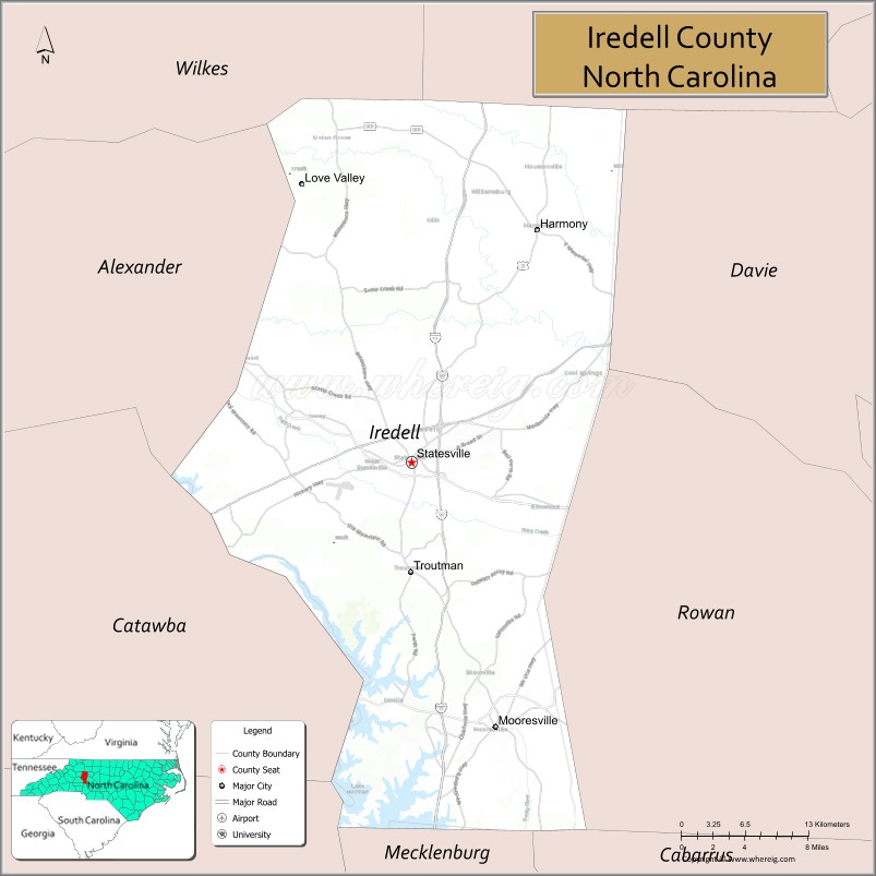
About Iredell County Map, North Carolina: The map showing the county boundary, county seat, major cities, highways, water bodies and neighbouring counties.
Related North Carolina Links
About Iredell County, North Carolina
Iredell County is a county located in the U.S. state of North Carolina. It's county seat is Statesville. As per 2020 census, the population of Iredell County is 191968 people and population density is square miles. According to the United States Census Bureau, the county has a total area of 597 sq mi (1,546 km2). Iredell County was established on 1788.
Iredell County Facts
| Continent | North America |
| Country | United States |
| State | North Carolina |
| County Seat | Statesville |
| Largest City/Town | Mooresville |
| Established | 1788 |
| Total Area | 597 sq mi (1,546 sq km) |
| Land Area | 574 sq mi (1,487 sq km) |
| Water Area | 23 sq mi (59 sq km) |
| Population | 186,693 (Census 2020) |
| Population Density | 325 people per sq mi |
| Time Zone | Eastern Time Zone (ET) |
| Major Highways | I-77, I-40, US-21, US-64, NC-150 |
| Major Rivers | Catawba River |
| Neighboring Counties | Yadkin County, Davie County, Rowan County, Cabarrus County, Mecklenburg County, Lincoln County, Alexander County |
| Famous For | NASCAR industry, Lake Norman, growing suburbs |
| Top Attractions | Lake Norman, Zootastic Park, Lazy 5 Ranch, Fort Dobbs State Historic Site |
| Official Website | Official Website |
About Iredell County, North Carolina
Iredell County is located in the central-western part of North Carolina, in the state of the United States, and was established in 1788. The county seat is Statesville, while Mooresville is the largest town. The county lies within the Piedmont region near the Charlotte metropolitan area and is known for its connection to the NASCAR industry, Lake Norman recreation, and rapid population growth.
Cities and Towns in Iredell County, North Carolina
| City/Town | Population (Census 2020) | Latitude & Longitude |
|---|---|---|
| Statesville (county seat) | 28,419 | 35.7826°N, 80.8873°W |
| Mooresville | 50,193 | 35.5849°N, 80.8101°W |
| Troutman | 3,570 | 35.7000°N, 80.8800°W |
| Harmony | 500 | 35.9700°N, 80.7700°W |
| Love Valley | 100 | 35.8600°N, 80.8600°W |
| Union Grove | 250 | 36.0200°N, 80.8500°W |
| Olin (CDP) | 2,000 | 35.9500°N, 80.9000°W |
Golf Courses in Iredell County, North Carolina
| Golf Course | Location | Latitude & Longitude |
|---|---|---|
| Mooresville Golf Club | Mooresville | 35.5800°N, 80.8100°W |
| Statesville Country Club | Statesville | 35.7800°N, 80.8900°W |
| The 500 Club | Statesville | 35.7600°N, 80.9000°W |
Roads and Highways in Iredell County, North Carolina
Iredell County is a key transportation hub in the region with major interstate access.
- I-77 – major north–south interstate connecting the county to Charlotte and Virginia
- I-40 – east–west route linking Statesville to Winston-Salem and Asheville
- US-21 – runs parallel to I-77 through the county
- US-64 – connects the county to central and western North Carolina
- NC-150 – provides regional access across the county
Neighboring Counties of Iredell County
- Yadkin County (north)
- Davie County (northeast)
- Rowan County (east)
- Cabarrus County (southeast)
- Mecklenburg County (south)
- Lincoln County (southwest)
- Alexander County (northwest)
Top Attractions in Iredell County, North Carolina
The county offers a mix of recreation, history, and family attractions.
- Lake Norman – largest man-made lake in North Carolina for boating and recreation
- Zootastic Park – animal park with interactive exhibits
- Lazy 5 Ranch – drive-through safari experience
- Fort Dobbs State Historic Site – Revolutionary War-era fort reconstruction
- Downtown Statesville – historic area with shops and dining
- NASCAR team shops in Mooresville – motorsports attractions
Distance from Iredell County to Nearby Cities
- Statesville to Charlotte – 40 mi (64 km)
- Statesville to Winston-Salem – 45 mi (72 km)
- Statesville to Greensboro – 70 mi (113 km)
- Statesville to Asheville – 90 mi (145 km)
- Statesville to Raleigh – 140 mi (225 km)
FAQs about Iredell County
Iredell County is located in central-western North Carolina near the Charlotte metropolitan area.
The population of Iredell County is 186,693 according to the 2020 Census.
Iredell County is known for its NASCAR industry, Lake Norman recreation, and growing communities.
Major highways include I-77, I-40, US-21, US-64, and NC-150.
Yes, Iredell County has several golf courses including Mooresville Golf Club and Statesville Country Club.
- Alamance County Map
- Alexander County Map
- Alleghany County Map
- Anson County Map
- Ashe County Map
- Avery County Map
- Beaufort County Map
- Bertie County Map
- Bladen County Map
- Brunswick County Map
- Buncombe County Map
- Burke County Map
- Cabarrus County Map
- Caldwell County Map
- Camden County Map
- Carteret County Map
- Caswell County Map
- Catawba County Map
- Chatham County Map
- Cherokee County Map
- Chowan County Map
- Clay County Map
- Cleveland County Map
- Columbus County Map
- Craven County Map
- Cumberland County Map
- Currituck County Map
- Dare County Map
- Davidson County Map
- Davie County Map
- Duplin County Map
- Durham County Map
- Edgecombe County Map
- Forsyth County Map
- Franklin County Map
- Gaston County Map
- Gates County Map
- Graham County Map
- Granville County Map
- Greene County Map
- Guilford County Map
- Halifax County Map
- Harnett County Map
- Haywood County Map
- Henderson County Map
- Hertford County Map
- Hoke County Map
- Hyde County Map
- Iredell County Map
- Jackson County Map
- Johnston County Map
- Jones County Map
- Lee County Map
- Lenoir County Map
- Lincoln County Map
- McDowell County Map
- Macon County Map
- Madison County Map
- Martin County Map
- Mecklenburg County Map
- Mitchell County Map
- Montgomery County Map
- Moore County Map
- Nash County Map
- New Hanover County Map
- Northampton County Map
- Onslow County Map
- Orange County Map
- Pamlico County Map
- Pasquotank County Map
- Pender County Map
- Perquimans County Map
- Person County Map
- Pitt County Map
- Polk County Map
- Randolph County Map
- Richmond County Map
- Robeson County Map
- Rockingham County Map
- Rowan County Map
- Rutherford County Map
- Sampson County Map
- Scotland County Map
- Stanly County Map
- Stokes County Map
- Surry County Map
- Swain County Map
- Transylvania County Map
- Tyrrell County Map
- Union County Map
- Vance County Map
- Wake County Map
- Warren County Map
- Washington County Map
- Watauga County Map
- Wayne County Map
- Wilkes County Map
- Wilson County Map
- Yadkin County Map
- Yancey County Map
- Alabama Counties
- Alaska boroughs
- Arizona Counties
- Arkansas Counties
- California County Map
- Colorado Counties
- Connecticut Counties
- Delaware Counties
- Florida County Map
- Georgia County Map
- Hawaii Counties
- Idaho Counties
- Illinois Counties
- Indiana Counties
- Iowa Counties
- Kansas Counties
- Kentucky Counties
- Louisiana Counties
- Maine Counties
- Maryland Counties
- Massachusetts Counties
- Michigan County Map
- Minnesota Counties
- Mississippi Counties
- Missouri Counties
- Montana Counties
- Nebraska Counties
- Nevada Counties
- New York Counties
- New Hampshire Counties
- New Jersey Counties
- New Mexico Counties
- North Carolina Counties
- North Dakota Counties
- Ohio County Map
- Oklahoma Counties
- Oregon Counties
- Pennsylvania Counties
- Rhode Island Counties
- South Carolina Counties
- South Dakota Counties
- Map of Tennessee
- Texas County Map
- Utah Counties
- Vermont Counties
- Virginia Counties
- Washington Counties
- West Virginia Counties
- Wisconsin Counties
- Wyoming Counties