Map of Tyrrell County - Tyrrell County is a county located in the U.S. state of North Carolina. Tyrrell County Map showing cities, highways, important places and water bodies. Get Where is Tyrrell County located in the map, major cities in Tyrrell county, population, areas, and places of interest.
Map of Tyrrell County, North Carolina
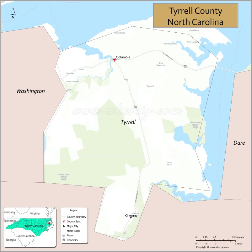
About Tyrrell County Map, North Carolina: The map showing the county boundary, county seat, major cities, highways, water bodies and neighbouring counties.
Most Viewed NC Maps & Info
About Tyrrell County, North Carolina
Tyrrell County is a county located in the U.S. state of North Carolina. It's county seat is Columbia. As per 2020 census, the population of Tyrrell County is 3254 people and population density is square miles. According to the United States Census Bureau, the county has a total area of 600 sq mi (1,554 km2). Tyrrell County was established on 1729.
Facts about Tyrrell County, North Carolina
| Country | United States |
| State | North Carolina |
| Region | Inner Banks / Coastal Plain (near Albemarle Sound) |
| County Seat | Columbia |
| Named After | Sir John Tyrrell (Lord Proprietor of Carolina) |
| Established | 1729 (as Tyrrell Precinct; became county 1738/9) |
| Coordinates | ~35.88° N, 76.02° W |
| Total Area | ~597.18 sq mi |
| Land Area | ~390.78 sq mi |
| Water Area | ~206.40 sq mi (≈34.5% water) |
| Population (2020) | ~3,245 |
| Estimated Population (2025) | ~3,437 |
| Population Rank (NC) | Least populous county in NC |
| Largest Town | Columbia |
| Main Towns & Communities | Columbia, Scuppernong, Kilkenny, Gum Neck, Fort Landing, Newfoundland, Woodley |
| Main Industries | Agriculture, Fishing, Forestry, Tourism & Services |
| Major Geographic Features | Albemarle Sound shoreline, Scuppernong & Alligator Rivers, wetlands & marshes |
| Time Zone | Eastern Time (UTC−05:00 / −04:00 DST) |
| Known For | Waterways & wetlands, Pocosin Lakes National Wildlife Refuge, quiet rural community |
| Website | https://www.tyrrellcountync.gov |
Top Attractions in Tyrrell County, North Carolina
- Pocosin Lakes National Wildlife Refuge – Birdwatching and nature trails.
- Albion Plantation – Historic plantation site.
- Piney Point Park – Fishing and picnic areas.
- Chowan River – Boating and scenic views.
- Columbia Downtown Historic District – Shops and dining.
- Tyrrell County Courthouse – Historic landmark.
- Pungo River Access – Canoeing and wildlife observation.
- Lake Phelps Nearby – Boating and fishing.
- Martin Marietta Boat Launch – River recreation.
- Historic Cemeteries – Heritage and local history.
Cities & Towns in Tyrrell County, North Carolina
Columbia, Blounts Creek, Pantego, East Lake, Tyrrell
- Alamance County Map
- Alexander County Map
- Alleghany County Map
- Anson County Map
- Ashe County Map
- Avery County Map
- Beaufort County Map
- Bertie County Map
- Bladen County Map
- Brunswick County Map
- Buncombe County Map
- Burke County Map
- Cabarrus County Map
- Caldwell County Map
- Camden County Map
- Carteret County Map
- Caswell County Map
- Catawba County Map
- Chatham County Map
- Cherokee County Map
- Chowan County Map
- Clay County Map
- Cleveland County Map
- Columbus County Map
- Craven County Map
- Cumberland County Map
- Currituck County Map
- Dare County Map
- Davidson County Map
- Davie County Map
- Duplin County Map
- Durham County Map
- Edgecombe County Map
- Forsyth County Map
- Franklin County Map
- Gaston County Map
- Gates County Map
- Graham County Map
- Granville County Map
- Greene County Map
- Guilford County Map
- Halifax County Map
- Harnett County Map
- Haywood County Map
- Henderson County Map
- Hertford County Map
- Hoke County Map
- Hyde County Map
- Iredell County Map
- Jackson County Map
- Johnston County Map
- Jones County Map
- Lee County Map
- Lenoir County Map
- Lincoln County Map
- McDowell County Map
- Macon County Map
- Madison County Map
- Martin County Map
- Mecklenburg County Map
- Mitchell County Map
- Montgomery County Map
- Moore County Map
- Nash County Map
- New Hanover County Map
- Northampton County Map
- Onslow County Map
- Orange County Map
- Pamlico County Map
- Pasquotank County Map
- Pender County Map
- Perquimans County Map
- Person County Map
- Pitt County Map
- Polk County Map
- Randolph County Map
- Richmond County Map
- Robeson County Map
- Rockingham County Map
- Rowan County Map
- Rutherford County Map
- Sampson County Map
- Scotland County Map
- Stanly County Map
- Stokes County Map
- Surry County Map
- Swain County Map
- Transylvania County Map
- Tyrrell County Map
- Union County Map
- Vance County Map
- Wake County Map
- Warren County Map
- Washington County Map
- Watauga County Map
- Wayne County Map
- Wilkes County Map
- Wilson County Map
- Yadkin County Map
- Yancey County Map
- Alabama Counties
- Alaska boroughs
- Arizona Counties
- Arkansas Counties
- California County Map
- Colorado Counties
- Connecticut Counties
- Delaware Counties
- Florida County Map
- Georgia County Map
- Hawaii Counties
- Idaho Counties
- Illinois Counties
- Indiana Counties
- Iowa Counties
- Kansas Counties
- Kentucky Counties
- Louisiana Counties
- Maine Counties
- Maryland Counties
- Massachusetts Counties
- Michigan County Map
- Minnesota Counties
- Mississippi Counties
- Missouri Counties
- Montana Counties
- Nebraska Counties
- New Hampshire Counties
- New Jersey Counties
- New Mexico Counties
- North Carolina Counties
- North Dakota Counties
- Oklahoma Counties
- Oregon Counties
- Pennsylvania Counties
- Rhode Island Counties
- South Carolina Counties
- South Dakota Counties
- Map of Tennessee
- Texas County Map
- Utah Counties
- Vermont Counties
- Virginia Counties
- Washington Counties
- West Virginia Counties
- Wisconsin Counties
- Wyoming Counties
- Nevada Counties
- New York Counties
- Ohio County Map