Map of Johnston County - Johnston County is a county located in the U.S. state of North Carolina. Johnston County Map showing cities, highways, important places and water bodies. Get Where is Johnston County located in the map, major cities in Johnston county, population, areas, and places of interest.
Map of Johnston County, North Carolina
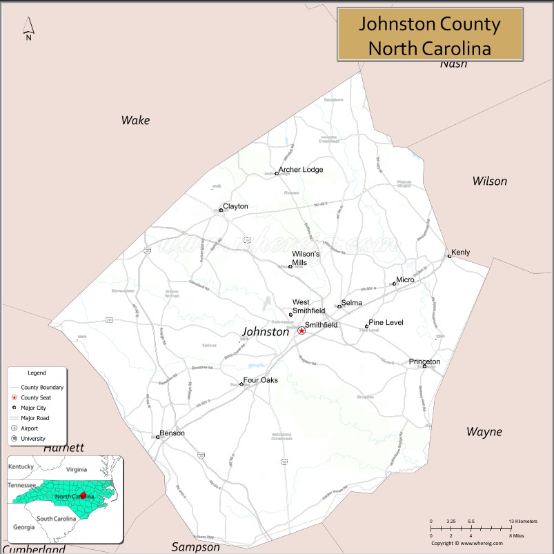
About Johnston County Map, North Carolina: The map showing the county boundary, county seat, major cities, highways, water bodies and neighbouring counties.
Related North Carolina Links
About Johnston County, North Carolina
Johnston County is a county located in the U.S. state of North Carolina. It's county seat is Smithfield. As per 2020 census, the population of Johnston County is 226504 people and population density is square miles. According to the United States Census Bureau, the county has a total area of 796 sq mi (2,062 km2). Johnston County was established on 1746.
Johnston County Facts
| Continent | North America |
| Country | United States |
| State | North Carolina |
| County Seat | Smithfield |
| Largest City/Town | Clayton |
| Established | 1746 |
| Total Area | 796 sq mi (2,061 sq km) |
| Land Area | 791 sq mi (2,049 sq km) |
| Water Area | 5 sq mi (12 sq km) |
| Population | 215,999 (Census 2020) |
| Population Density | 273 people per sq mi |
| Time Zone | Eastern Time Zone (ET) |
| Major Highways | I-95, I-40, US-70, US-301, NC-42 |
| Major Rivers | Neuse River |
| Neighboring Counties | Wake County, Wilson County, Wayne County, Sampson County, Harnett County |
| Famous For | Outlet shopping, agriculture, proximity to Raleigh |
| Top Attractions | Carolina Premium Outlets, Ava Gardner Museum, Bentonville Battlefield, Howell Woods Environmental Learning Center |
| Official Website | Official Website |
About Johnston County, North Carolina
Johnston County is located in the east-central part of North Carolina, in the state of the United States, and was established in 1746. The county seat is Smithfield, while Clayton is the largest town. The county lies just southeast of Raleigh and is known for its agricultural heritage, growing suburban communities, and popular shopping destinations.
Cities and Towns in Johnston County, North Carolina
| City/Town | Population (Census 2020) | Latitude & Longitude |
|---|---|---|
| Clayton | 26,307 | 35.6507°N, 78.4564°W |
| Smithfield (county seat) | 12,985 | 35.5085°N, 78.3394°W |
| Selma | 6,073 | 35.5368°N, 78.2842°W |
| Benson | 3,743 | 35.3824°N, 78.5486°W |
| Four Oaks | 2,424 | 35.4443°N, 78.4264°W |
| Kenly | 1,500 | 35.5960°N, 78.1200°W |
| Princeton | 1,300 | 35.4640°N, 78.1580°W |
| Pine Level | 1,700 | 35.5140°N, 78.2300°W |
| Micro | 500 | 35.5700°N, 78.2100°W |
| Wilson’s Mills | 2,300 | 35.5800°N, 78.3600°W |
Golf Courses in Johnston County, North Carolina
| Golf Course | Location | Latitude & Longitude |
|---|---|---|
| Reedy Creek Golf Course | Four Oaks | 35.4400°N, 78.4200°W |
| Cardinal Country Club | Selma | 35.5300°N, 78.2800°W |
| Hedingham Golf Club (nearby) | Clayton area | 35.6500°N, 78.4500°W |
Roads and Highways in Johnston County, North Carolina
Johnston County is a key transportation corridor in eastern North Carolina.
- I-95 – major north–south interstate running through the county
- I-40 – connects the county to Raleigh and Wilmington
- US-70 – runs east–west linking the county to Raleigh and Goldsboro
- US-301 – runs parallel to I-95
- NC-42 – connects Clayton to other parts of the county
Neighboring Counties of Johnston County
- Wake County (north)
- Wilson County (northeast)
- Wayne County (southeast)
- Sampson County (south)
- Harnett County (west)
Top Attractions in Johnston County, North Carolina
The county offers shopping, history, and outdoor recreation.
- Carolina Premium Outlets – popular shopping destination in Smithfield
- Ava Gardner Museum – museum dedicated to the famous actress
- Bentonville Battlefield State Historic Site – Civil War site
- Howell Woods Environmental Learning Center – nature preserve with trails
- Downtown Clayton – growing area with shops and restaurants
- Local farms and markets – agricultural experiences
Distance from Johnston County to Nearby Cities
- Smithfield to Raleigh – 30 mi (48 km)
- Smithfield to Goldsboro – 25 mi (40 km)
- Smithfield to Fayetteville – 50 mi (80 km)
- Smithfield to Durham – 50 mi (80 km)
- Smithfield to Wilmington – 110 mi (177 km)
FAQs about Johnston County
Johnston County is located in east-central North Carolina near the Raleigh metropolitan area.
The population of Johnston County is 215,999 according to the 2020 Census.
Johnston County is known for its outlet shopping, agriculture, and growing suburban communities.
Major highways include I-95, I-40, US-70, US-301, and NC-42.
Yes, Johnston County has several golf courses including Reedy Creek Golf Course and Cardinal Country Club.
- Alamance County Map
- Alexander County Map
- Alleghany County Map
- Anson County Map
- Ashe County Map
- Avery County Map
- Beaufort County Map
- Bertie County Map
- Bladen County Map
- Brunswick County Map
- Buncombe County Map
- Burke County Map
- Cabarrus County Map
- Caldwell County Map
- Camden County Map
- Carteret County Map
- Caswell County Map
- Catawba County Map
- Chatham County Map
- Cherokee County Map
- Chowan County Map
- Clay County Map
- Cleveland County Map
- Columbus County Map
- Craven County Map
- Cumberland County Map
- Currituck County Map
- Dare County Map
- Davidson County Map
- Davie County Map
- Duplin County Map
- Durham County Map
- Edgecombe County Map
- Forsyth County Map
- Franklin County Map
- Gaston County Map
- Gates County Map
- Graham County Map
- Granville County Map
- Greene County Map
- Guilford County Map
- Halifax County Map
- Harnett County Map
- Haywood County Map
- Henderson County Map
- Hertford County Map
- Hoke County Map
- Hyde County Map
- Iredell County Map
- Jackson County Map
- Johnston County Map
- Jones County Map
- Lee County Map
- Lenoir County Map
- Lincoln County Map
- McDowell County Map
- Macon County Map
- Madison County Map
- Martin County Map
- Mecklenburg County Map
- Mitchell County Map
- Montgomery County Map
- Moore County Map
- Nash County Map
- New Hanover County Map
- Northampton County Map
- Onslow County Map
- Orange County Map
- Pamlico County Map
- Pasquotank County Map
- Pender County Map
- Perquimans County Map
- Person County Map
- Pitt County Map
- Polk County Map
- Randolph County Map
- Richmond County Map
- Robeson County Map
- Rockingham County Map
- Rowan County Map
- Rutherford County Map
- Sampson County Map
- Scotland County Map
- Stanly County Map
- Stokes County Map
- Surry County Map
- Swain County Map
- Transylvania County Map
- Tyrrell County Map
- Union County Map
- Vance County Map
- Wake County Map
- Warren County Map
- Washington County Map
- Watauga County Map
- Wayne County Map
- Wilkes County Map
- Wilson County Map
- Yadkin County Map
- Yancey County Map
- Alabama Counties
- Alaska boroughs
- Arizona Counties
- Arkansas Counties
- California County Map
- Colorado Counties
- Connecticut Counties
- Delaware Counties
- Florida County Map
- Georgia County Map
- Hawaii Counties
- Idaho Counties
- Illinois Counties
- Indiana Counties
- Iowa Counties
- Kansas Counties
- Kentucky Counties
- Louisiana Counties
- Maine Counties
- Maryland Counties
- Massachusetts Counties
- Michigan County Map
- Minnesota Counties
- Mississippi Counties
- Missouri Counties
- Montana Counties
- Nebraska Counties
- Nevada Counties
- New York Counties
- New Hampshire Counties
- New Jersey Counties
- New Mexico Counties
- North Carolina Counties
- North Dakota Counties
- Ohio County Map
- Oklahoma Counties
- Oregon Counties
- Pennsylvania Counties
- Rhode Island Counties
- South Carolina Counties
- South Dakota Counties
- Map of Tennessee
- Texas County Map
- Utah Counties
- Vermont Counties
- Virginia Counties
- Washington Counties
- West Virginia Counties
- Wisconsin Counties
- Wyoming Counties