Map of Durham County - Durham County is a county located in the U.S. state of North Carolina. Durham County Map showing cities, highways, important places and water bodies. Get Where is Durham County located in the map, major cities in Durham county, population, areas, and places of interest.
Map of Durham County, North Carolina
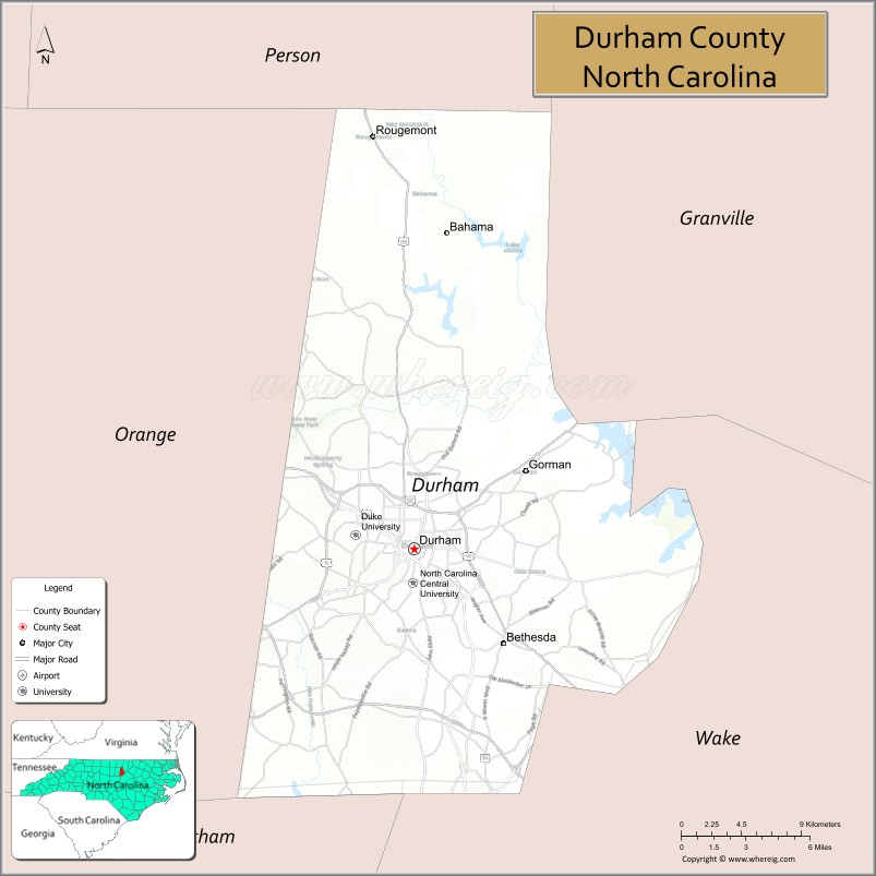
About Durham County Map, North Carolina: The map showing the county boundary, county seat, major cities, highways, water bodies and neighbouring counties.
Related North Carolina Links
About Durham County, North Carolina
Durham County is a county located in the U.S. state of North Carolina. It's county seat is Durham. As per 2020 census, the population of Durham County is 326126 people and population density is square miles. According to the United States Census Bureau, the county has a total area of 298 sq mi (772 km2). Durham County was established on 1881.
Durham County Facts
| Continent | North America |
| Country | United States |
| State | North Carolina |
| County Seat | Durham |
| Largest City/Town | Durham |
| Established | 1881 |
| Total Area | 298 sq mi (772 sq km) |
| Land Area | 286 sq mi (741 sq km) |
| Water Area | 12 sq mi (31 sq km) |
| Population | 324,833 (Census 2020) |
| Population Density | 1,136 people per sq mi |
| Time Zone | Eastern Time Zone (ET) |
| Major Highways | I-40, I-85, US-15/501, US-70, NC-147, NC-54 |
| Major Rivers | Eno River, Little River |
| Neighboring Counties | Person County, Granville County, Wake County, Orange County, Chatham County |
| Famous For | Research Triangle, universities, healthcare, technology |
| Top Attractions | Duke University, Sarah P. Duke Gardens, Museum of Life and Science, Eno River State Park |
| Official Website | Official Website |
About Durham County, North Carolina
Durham County is located in the north-central part of North Carolina, in the state of the United States, and was established in 1881. The county seat is Durham, which is also the largest city. The county is part of the Research Triangle region and is known for its universities, healthcare institutions, and growing technology and research sectors.
Cities and Towns in Durham County, North Carolina
| City/Town | Population (Census 2020) | Latitude & Longitude |
|---|---|---|
| Durham (county seat) | 283,506 | 35.9940°N, 78.8986°W |
| Chapel Hill (partly in Orange County) | 61,960 | 35.9132°N, 79.0558°W |
| Research Triangle Park (CDP) | 7,000 | 35.9000°N, 78.8700°W |
| Rougemont (CDP) | 1,000 | 36.2000°N, 78.9000°W |
| Bahama (CDP) | 1,500 | 36.1800°N, 78.8800°W |
| Gorman (CDP) | 1,200 | 35.9800°N, 78.9500°W |
Golf Courses in Durham County, North Carolina
| Golf Course | Location | Latitude & Longitude |
|---|---|---|
| Duke University Golf Club | Durham | 36.0000°N, 78.9400°W |
| Hillandale Golf Course | Durham | 36.0200°N, 78.9200°W |
| Falls Village Golf Club | Durham | 36.0800°N, 78.9200°W |
| Treyburn Country Club | Durham | 36.0800°N, 78.8800°W |
Roads and Highways in Durham County, North Carolina
Durham County is a major transportation hub within the Research Triangle.
- I-40 – connects Durham to Raleigh, Chapel Hill, and the coast
- I-85 – links Durham to Greensboro and Virginia
- US-15/501 – runs north–south connecting Durham to Chapel Hill
- US-70 – provides access across the county and region
- NC-147 (Durham Freeway) – major urban route through Durham
- NC-54 – connects Durham to Chapel Hill and Cary
Neighboring Counties of Durham County
- Person County (north)
- Granville County (northeast)
- Wake County (east)
- Chatham County (south)
- Orange County (west)
Top Attractions in Durham County, North Carolina
The county offers a mix of education, culture, and outdoor recreation.
- Duke University – prestigious university with historic campus and architecture
- Sarah P. Duke Gardens – beautiful botanical gardens on the Duke campus
- Museum of Life and Science – interactive science museum for all ages
- Eno River State Park – scenic park with hiking trails and river access
- Durham Bulls Athletic Park – minor league baseball stadium
- American Tobacco Campus – redeveloped historic area with dining and entertainment
Distance from Durham County to Nearby Cities
- Durham to Raleigh – 25 mi (40 km)
- Durham to Chapel Hill – 10 mi (16 km)
- Durham to Greensboro – 55 mi (89 km)
- Durham to Charlotte – 140 mi (225 km)
- Durham to Richmond, VA – 150 mi (241 km)
FAQs about Durham County
Durham County is located in north-central North Carolina as part of the Research Triangle region.
The population of Durham County is 324,833 according to the 2020 Census.
Durham County is known for its universities, research institutions, healthcare, and technology industries.
Major highways include I-40, I-85, US-15/501, US-70, NC-147, and NC-54.
Yes, Durham County has several golf courses including Duke University Golf Club and Treyburn Country Club.
- Alamance County Map
- Alexander County Map
- Alleghany County Map
- Anson County Map
- Ashe County Map
- Avery County Map
- Beaufort County Map
- Bertie County Map
- Bladen County Map
- Brunswick County Map
- Buncombe County Map
- Burke County Map
- Cabarrus County Map
- Caldwell County Map
- Camden County Map
- Carteret County Map
- Caswell County Map
- Catawba County Map
- Chatham County Map
- Cherokee County Map
- Chowan County Map
- Clay County Map
- Cleveland County Map
- Columbus County Map
- Craven County Map
- Cumberland County Map
- Currituck County Map
- Dare County Map
- Davidson County Map
- Davie County Map
- Duplin County Map
- Durham County Map
- Edgecombe County Map
- Forsyth County Map
- Franklin County Map
- Gaston County Map
- Gates County Map
- Graham County Map
- Granville County Map
- Greene County Map
- Guilford County Map
- Halifax County Map
- Harnett County Map
- Haywood County Map
- Henderson County Map
- Hertford County Map
- Hoke County Map
- Hyde County Map
- Iredell County Map
- Jackson County Map
- Johnston County Map
- Jones County Map
- Lee County Map
- Lenoir County Map
- Lincoln County Map
- McDowell County Map
- Macon County Map
- Madison County Map
- Martin County Map
- Mecklenburg County Map
- Mitchell County Map
- Montgomery County Map
- Moore County Map
- Nash County Map
- New Hanover County Map
- Northampton County Map
- Onslow County Map
- Orange County Map
- Pamlico County Map
- Pasquotank County Map
- Pender County Map
- Perquimans County Map
- Person County Map
- Pitt County Map
- Polk County Map
- Randolph County Map
- Richmond County Map
- Robeson County Map
- Rockingham County Map
- Rowan County Map
- Rutherford County Map
- Sampson County Map
- Scotland County Map
- Stanly County Map
- Stokes County Map
- Surry County Map
- Swain County Map
- Transylvania County Map
- Tyrrell County Map
- Union County Map
- Vance County Map
- Wake County Map
- Warren County Map
- Washington County Map
- Watauga County Map
- Wayne County Map
- Wilkes County Map
- Wilson County Map
- Yadkin County Map
- Yancey County Map
- Alabama Counties
- Alaska boroughs
- Arizona Counties
- Arkansas Counties
- California County Map
- Colorado Counties
- Connecticut Counties
- Delaware Counties
- Florida County Map
- Georgia County Map
- Hawaii Counties
- Idaho Counties
- Illinois Counties
- Indiana Counties
- Iowa Counties
- Kansas Counties
- Kentucky Counties
- Louisiana Counties
- Maine Counties
- Maryland Counties
- Massachusetts Counties
- Michigan County Map
- Minnesota Counties
- Mississippi Counties
- Missouri Counties
- Montana Counties
- Nebraska Counties
- Nevada Counties
- New York Counties
- New Hampshire Counties
- New Jersey Counties
- New Mexico Counties
- North Carolina Counties
- North Dakota Counties
- Ohio County Map
- Oklahoma Counties
- Oregon Counties
- Pennsylvania Counties
- Rhode Island Counties
- South Carolina Counties
- South Dakota Counties
- Map of Tennessee
- Texas County Map
- Utah Counties
- Vermont Counties
- Virginia Counties
- Washington Counties
- West Virginia Counties
- Wisconsin Counties
- Wyoming Counties