Map of Guilford County - Guilford County is a county located in the U.S. state of North Carolina. Guilford County Map showing cities, highways, important places and water bodies. Get Where is Guilford County located in the map, major cities in Guilford county, population, areas, and places of interest.
Map of Guilford County, North Carolina
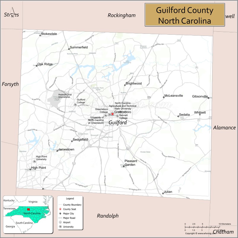
About Guilford County Map, North Carolina: The map showing the county boundary, county seat, major cities, highways, water bodies and neighbouring counties.
Related North Carolina Links
About Guilford County, North Carolina
Guilford County is a county located in the U.S. state of North Carolina. It's county seat is Greensboro. As per 2020 census, the population of Guilford County is 542410 people and population density is square miles. According to the United States Census Bureau, the county has a total area of 658 sq mi (1,704 km2). Guilford County was established on 1771.
Guilford County Facts
| Continent | North America |
| Country | United States |
| State | North Carolina |
| County Seat | Greensboro |
| Largest City/Town | Greensboro |
| Established | 1771 |
| Total Area | 658 sq mi (1,704 sq km) |
| Land Area | 646 sq mi (1,673 sq km) |
| Water Area | 12 sq mi (31 sq km) |
| Population | 541,299 (Census 2020) |
| Population Density | 838 people per sq mi |
| Time Zone | Eastern Time Zone (ET) |
| Major Highways | I-40, I-73, I-85, US-29, US-70, US-421 |
| Major Rivers | Haw River, Deep River |
| Neighboring Counties | Rockingham County, Alamance County, Randolph County, Davidson County, Forsyth County |
| Famous For | Piedmont Triad, civil rights history, universities |
| Top Attractions | Greensboro Science Center, International Civil Rights Center & Museum, Wet'n Wild Emerald Pointe, High Point Furniture Market |
| Official Website | Official Website |
About Guilford County, North Carolina
Guilford County is located in the north-central part of North Carolina, in the state of the United States, and was established in 1771. The county seat is Greensboro, which is also the largest city. The county is part of the Piedmont Triad region and is known for its role in the civil rights movement, educational institutions, and economic importance.
Cities and Towns in Guilford County, North Carolina
| City/Town | Population (Census 2020) | Latitude & Longitude |
|---|---|---|
| Greensboro (county seat) | 299,035 | 36.0726°N, 79.7920°W |
| High Point (partly in Davidson County) | 114,059 | 35.9557°N, 80.0053°W |
| Jamestown | 3,990 | 35.9943°N, 79.9359°W |
| Oak Ridge | 7,474 | 36.1737°N, 79.9892°W |
| Summerfield | 11,000 | 36.2079°N, 79.9050°W |
| Stokesdale | 5,000 | 36.2376°N, 79.9784°W |
| Whitsett | 700 | 36.0318°N, 79.6136°W |
| Pleasant Garden | 4,500 | 35.9590°N, 79.7660°W |
| Gibsonville (partly in Alamance County) | 8,700 | 36.1068°N, 79.5422°W |
Golf Courses in Guilford County, North Carolina
| Golf Course | Location | Latitude & Longitude |
|---|---|---|
| Grandover Resort Golf Course | Greensboro | 36.0000°N, 79.8400°W |
| Sedgefield Country Club | Greensboro | 36.0200°N, 79.8500°W |
| Starmount Forest Country Club | Greensboro | 36.0800°N, 79.8400°W |
| Oak Hollow Golf Course | High Point | 35.9800°N, 80.0300°W |
Roads and Highways in Guilford County, North Carolina
Guilford County is a major transportation hub in the Piedmont Triad region.
- I-40 – major east–west interstate connecting Greensboro to Raleigh and Winston-Salem
- I-85 – runs northeast–southwest through the county
- I-73 – connects the county to northern and southern regions
- US-29 – links Greensboro to Virginia and Charlotte
- US-70 – provides regional access across the county
- US-421 – connects the county to Boone and other areas
Neighboring Counties of Guilford County
- Rockingham County (north)
- Alamance County (east)
- Randolph County (south)
- Davidson County (southwest)
- Forsyth County (west)
Top Attractions in Guilford County, North Carolina
The county offers a wide range of cultural, historical, and recreational attractions.
- Greensboro Science Center – zoo, aquarium, and museum combined
- International Civil Rights Center & Museum – historic site of the Greensboro sit-ins
- Wet'n Wild Emerald Pointe – large water park with rides and attractions
- High Point Furniture Market – major international furniture trade event
- Tanger Family Bicentennial Garden – scenic gardens and walking paths
- Guilford Courthouse National Military Park – Revolutionary War site
Distance from Guilford County to Nearby Cities
- Greensboro to Winston-Salem – 30 mi (48 km)
- Greensboro to Durham – 55 mi (89 km)
- Greensboro to Charlotte – 90 mi (145 km)
- Greensboro to Raleigh – 80 mi (129 km)
- Greensboro to Asheville – 160 mi (257 km)
FAQs about Guilford County
Guilford County is located in north-central North Carolina in the Piedmont Triad region.
The population of Guilford County is 541,299 according to the 2020 Census.
Guilford County is known for its role in the civil rights movement, universities, and economic importance.
Major highways include I-40, I-85, I-73, US-29, US-70, and US-421.
Yes, Guilford County has several golf courses including Grandover Resort and Sedgefield Country Club.
- Alamance County Map
- Alexander County Map
- Alleghany County Map
- Anson County Map
- Ashe County Map
- Avery County Map
- Beaufort County Map
- Bertie County Map
- Bladen County Map
- Brunswick County Map
- Buncombe County Map
- Burke County Map
- Cabarrus County Map
- Caldwell County Map
- Camden County Map
- Carteret County Map
- Caswell County Map
- Catawba County Map
- Chatham County Map
- Cherokee County Map
- Chowan County Map
- Clay County Map
- Cleveland County Map
- Columbus County Map
- Craven County Map
- Cumberland County Map
- Currituck County Map
- Dare County Map
- Davidson County Map
- Davie County Map
- Duplin County Map
- Durham County Map
- Edgecombe County Map
- Forsyth County Map
- Franklin County Map
- Gaston County Map
- Gates County Map
- Graham County Map
- Granville County Map
- Greene County Map
- Guilford County Map
- Halifax County Map
- Harnett County Map
- Haywood County Map
- Henderson County Map
- Hertford County Map
- Hoke County Map
- Hyde County Map
- Iredell County Map
- Jackson County Map
- Johnston County Map
- Jones County Map
- Lee County Map
- Lenoir County Map
- Lincoln County Map
- McDowell County Map
- Macon County Map
- Madison County Map
- Martin County Map
- Mecklenburg County Map
- Mitchell County Map
- Montgomery County Map
- Moore County Map
- Nash County Map
- New Hanover County Map
- Northampton County Map
- Onslow County Map
- Orange County Map
- Pamlico County Map
- Pasquotank County Map
- Pender County Map
- Perquimans County Map
- Person County Map
- Pitt County Map
- Polk County Map
- Randolph County Map
- Richmond County Map
- Robeson County Map
- Rockingham County Map
- Rowan County Map
- Rutherford County Map
- Sampson County Map
- Scotland County Map
- Stanly County Map
- Stokes County Map
- Surry County Map
- Swain County Map
- Transylvania County Map
- Tyrrell County Map
- Union County Map
- Vance County Map
- Wake County Map
- Warren County Map
- Washington County Map
- Watauga County Map
- Wayne County Map
- Wilkes County Map
- Wilson County Map
- Yadkin County Map
- Yancey County Map
- Alabama Counties
- Alaska boroughs
- Arizona Counties
- Arkansas Counties
- California County Map
- Colorado Counties
- Connecticut Counties
- Delaware Counties
- Florida County Map
- Georgia County Map
- Hawaii Counties
- Idaho Counties
- Illinois Counties
- Indiana Counties
- Iowa Counties
- Kansas Counties
- Kentucky Counties
- Louisiana Counties
- Maine Counties
- Maryland Counties
- Massachusetts Counties
- Michigan County Map
- Minnesota Counties
- Mississippi Counties
- Missouri Counties
- Montana Counties
- Nebraska Counties
- Nevada Counties
- New York Counties
- New Hampshire Counties
- New Jersey Counties
- New Mexico Counties
- North Carolina Counties
- North Dakota Counties
- Ohio County Map
- Oklahoma Counties
- Oregon Counties
- Pennsylvania Counties
- Rhode Island Counties
- South Carolina Counties
- South Dakota Counties
- Map of Tennessee
- Texas County Map
- Utah Counties
- Vermont Counties
- Virginia Counties
- Washington Counties
- West Virginia Counties
- Wisconsin Counties
- Wyoming Counties