Map of Brunswick County - Brunswick County is a county located in the U.S. state of North Carolina. Brunswick County Map showing cities, highways, important places and water bodies. Get Where is Brunswick County located in the map, major cities in Brunswick county, population, areas, and places of interest.
Map of Brunswick County, North Carolina
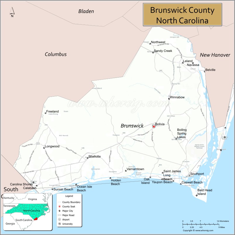
About Brunswick County Map, North Carolina: The map showing the county boundary, county seat, major cities, highways, water bodies and neighbouring counties.
Related North Carolina Links
About Brunswick County, North Carolina
Brunswick County is a county located in the U.S. state of North Carolina. It's county seat is Bolivia. As per 2020 census, the population of Brunswick County is 144215 people and population density is square miles. According to the United States Census Bureau, the county has a total area of 860 sq mi (2,227 km2). Brunswick County was established on 1764.
Brunswick County Facts
| Continent | North America |
| Country | United States |
| State | North Carolina |
| County Seat | Bolivia |
| Largest City/Town | Leland |
| Established | 1764 |
| Total Area | 1,050 sq mi (2,720 sq km) |
| Land Area | 847 sq mi (2,194 sq km) |
| Water Area | 203 sq mi (526 sq km) |
| Population | 136,693 (Census 2020) |
| Population Density | 161 people per sq mi |
| Time Zone | Eastern Time Zone (ET) |
| Major Highways | US-17, US-74, US-76, NC-87, NC-133, NC-211, NC-904 |
| Major Rivers | Cape Fear River, Lockwood Folly River, Shallotte River |
| Neighboring Counties | New Hanover County, Columbus County, Horry County (SC) |
| Famous For | Coastal beaches, golf resorts, barrier islands, Cape Fear River |
| Top Attractions | Oak Island, Bald Head Island, Holden Beach, Southport Waterfront, Brunswick Islands |
| Official Website | Official Website |
About Brunswick County, North Carolina
Brunswick County is located in the southeastern part of North Carolina, in the state of the United States, and was established in 1764. The county seat is Bolivia, while Leland is the largest town. The county sits along the Atlantic coast and is known for its barrier islands, sandy beaches, coastal communities, and strong tourism and golf industry.
Cities and Towns in Brunswick County, North Carolina
| City/Town | Population (Census 2020) | Latitude & Longitude |
|---|---|---|
| Bolivia (county seat) | 189 | 34.0679°N, 78.1483°W |
| Leland | 23,504 | 34.2563°N, 78.0447°W |
| Southport | 4,159 | 33,9216°N, 78.0200°W |
| Shallotte | 4,575 | 33.9738°N, 78.3856°W |
| Ocean Isle Beach | 867 | 33.8943°N, 78.4264°W |
| Sunset Beach | 3,987 | 33.8807°N, 78.5072°W |
| Holden Beach | 1,284 | 33.9135°N, 78.3036°W |
| Oak Island | 8,396 | 33.9316°N, 78.0767°W |
| Belville | 2,171 | 34.2346°N, 78.0219°W |
| Bald Head Island | 268 | 33.8574°N, 77.9950°W |
| Calabash | 2,026 | 33.8902°N, 78.5667°W |
| Carolina Shores | 4,361 | 33.8899°N, 78.5733°W |
| Caswell Beach | 395 | 33.9088°N, 78.0425°W |
| Navassa | 2,118 | 34.2555°N, 77.9950°W |
| Northwest | 735 | 34.2960°N, 78.2010°W |
| Sandy Creek (CDP) | 500 | 34.1500°N, 78.2000°W |
| St. James (CDP) | 6,529 | 33.9448°N, 78.1045°W |
| Boiling Spring Lakes (CDP) | 6,024 | 34.0338°N, 78.0672°W |
Golf Courses in Brunswick County, North Carolina
| Golf Course | Location | Latitude & Longitude |
|---|---|---|
| Brunswick Plantation & Golf Resort | Calabash | 33.8880°N, 78.5735°W |
| Oyster Bay Golf Links | Sunset Beach | 33.8800°N, 78.5000°W |
| Sea Trail Golf Resort | Sunset Beach | 33.8770°N, 78.5050°W |
| Lockwood Folly Country Club | Holden Beach | 33.9190°N, 78.2700°W |
| Carolina National Golf Club | Bolivia | 34.0600°N, 78.1400°W |
| Cape Fear National Golf Course | Leland | 34.2500°N, 78.0400°W |
| The Lakes Country Club | Boiling Spring Lakes | 34.0400°N, 78.0600°W |
| Magnolia Greens Golf Plantation | Leland | 34.2200°N, 78.0300°W |
Roads and Highways in Brunswick County, North Carolina
Brunswick County is well connected by major highways serving coastal and inland travel.
- US-17 – main north–south coastal highway linking Wilmington to South Carolina
- US-74 / US-76 – connects Leland and Wilmington to inland areas
- NC-87 – runs from Southport north toward Fayetteville
- NC-133 – connects Leland to Southport
- NC-211 – links Southport to Shallotte and inland communities
- NC-904 – provides access to coastal towns and beaches
Neighboring Counties of Brunswick County
- New Hanover County (northeast)
- Columbus County (northwest)
- Horry County, South Carolina (southwest)
Top Attractions in Brunswick County, North Carolina
The county is a popular coastal destination with beaches and outdoor recreation.
- Oak Island – family-friendly beach with fishing pier and lighthouse
- Bald Head Island – car-free island with historic lighthouse and nature preserves
- Holden Beach – quiet barrier island known for its relaxed atmosphere
- Sunset Beach – scenic beach famous for beautiful sunsets and Bird Island Reserve
- Southport Waterfront – charming coastal town with shops, marinas, and views
- Brunswick Islands – collection of beaches and coastal communities
- North Carolina Maritime Museum at Southport – exhibits on coastal history and shipwrecks
Distance from Brunswick County to Nearby Cities
- Bolivia to Wilmington – 20 mi (32 km)
- Bolivia to Myrtle Beach, SC – 60 mi (97 km)
- Bolivia to Fayetteville – 90 mi (145 km)
- Bolivia to Raleigh – 150 mi (241 km)
- Bolivia to Charleston, SC – 170 mi (274 km)
FAQs about Brunswick County
Brunswick County is located in southeastern North Carolina along the Atlantic coast near South Carolina.
The population of Brunswick County is 136,693 according to the 2020 Census.
Brunswick County is known for its beaches, golf resorts, coastal towns, and barrier islands.
Major highways include US-17, US-74, US-76, NC-87, NC-133, NC-211, and NC-904.
Yes, Brunswick County has many golf courses including Brunswick Plantation, Oyster Bay Golf Links, Sea Trail Golf Resort, and Magnolia Greens.
- Alamance County Map
- Alexander County Map
- Alleghany County Map
- Anson County Map
- Ashe County Map
- Avery County Map
- Beaufort County Map
- Bertie County Map
- Bladen County Map
- Brunswick County Map
- Buncombe County Map
- Burke County Map
- Cabarrus County Map
- Caldwell County Map
- Camden County Map
- Carteret County Map
- Caswell County Map
- Catawba County Map
- Chatham County Map
- Cherokee County Map
- Chowan County Map
- Clay County Map
- Cleveland County Map
- Columbus County Map
- Craven County Map
- Cumberland County Map
- Currituck County Map
- Dare County Map
- Davidson County Map
- Davie County Map
- Duplin County Map
- Durham County Map
- Edgecombe County Map
- Forsyth County Map
- Franklin County Map
- Gaston County Map
- Gates County Map
- Graham County Map
- Granville County Map
- Greene County Map
- Guilford County Map
- Halifax County Map
- Harnett County Map
- Haywood County Map
- Henderson County Map
- Hertford County Map
- Hoke County Map
- Hyde County Map
- Iredell County Map
- Jackson County Map
- Johnston County Map
- Jones County Map
- Lee County Map
- Lenoir County Map
- Lincoln County Map
- McDowell County Map
- Macon County Map
- Madison County Map
- Martin County Map
- Mecklenburg County Map
- Mitchell County Map
- Montgomery County Map
- Moore County Map
- Nash County Map
- New Hanover County Map
- Northampton County Map
- Onslow County Map
- Orange County Map
- Pamlico County Map
- Pasquotank County Map
- Pender County Map
- Perquimans County Map
- Person County Map
- Pitt County Map
- Polk County Map
- Randolph County Map
- Richmond County Map
- Robeson County Map
- Rockingham County Map
- Rowan County Map
- Rutherford County Map
- Sampson County Map
- Scotland County Map
- Stanly County Map
- Stokes County Map
- Surry County Map
- Swain County Map
- Transylvania County Map
- Tyrrell County Map
- Union County Map
- Vance County Map
- Wake County Map
- Warren County Map
- Washington County Map
- Watauga County Map
- Wayne County Map
- Wilkes County Map
- Wilson County Map
- Yadkin County Map
- Yancey County Map
- Alabama Counties
- Alaska boroughs
- Arizona Counties
- Arkansas Counties
- California County Map
- Colorado Counties
- Connecticut Counties
- Delaware Counties
- Florida County Map
- Georgia County Map
- Hawaii Counties
- Idaho Counties
- Illinois Counties
- Indiana Counties
- Iowa Counties
- Kansas Counties
- Kentucky Counties
- Louisiana Counties
- Maine Counties
- Maryland Counties
- Massachusetts Counties
- Michigan County Map
- Minnesota Counties
- Mississippi Counties
- Missouri Counties
- Montana Counties
- Nebraska Counties
- Nevada Counties
- New York Counties
- New Hampshire Counties
- New Jersey Counties
- New Mexico Counties
- North Carolina Counties
- North Dakota Counties
- Ohio County Map
- Oklahoma Counties
- Oregon Counties
- Pennsylvania Counties
- Rhode Island Counties
- South Carolina Counties
- South Dakota Counties
- Map of Tennessee
- Texas County Map
- Utah Counties
- Vermont Counties
- Virginia Counties
- Washington Counties
- West Virginia Counties
- Wisconsin Counties
- Wyoming Counties