Map of Person County - Person County is a county located in the U.S. state of North Carolina. Person County Map showing cities, highways, important places and water bodies. Get Where is Person County located in the map, major cities in Person county, population, areas, and places of interest.
Map of Person County, North Carolina
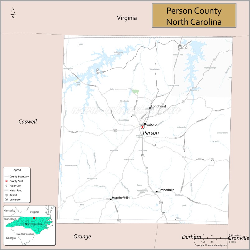
About Person County Map, North Carolina: The map showing the county boundary, county seat, major cities, highways, water bodies and neighbouring counties.
Related North Carolina Links
About Person County, North Carolina
Person County is a county located in the U.S. state of North Carolina. It's county seat is Roxboro. As per 2020 census, the population of Person County is 39127 people and population density is square miles. According to the United States Census Bureau, the county has a total area of 404 sq mi (1,046 km2). Person County was established on 1791.
Person County Facts
| Continent | North America |
| Country | United States |
| State | North Carolina |
| County Seat | Roxboro |
| Largest City/Town | Roxboro |
| Established | 1792 |
| Total Area | 404 sq mi (1,046 sq km) |
| Land Area | 392 sq mi (1,015 sq km) |
| Water Area | 12 sq mi (31 sq km) |
| Population | 39,097 (Census 2020) |
| Population Density | 100 people per sq mi |
| Time Zone | Eastern Time Zone (ET) |
| Major Highways | US-501, NC-49, NC-57, NC-158 |
| Major Rivers | Dan River, Hyco River |
| Neighboring Counties | Caswell County, Granville County, Durham County, Orange County, Halifax County (VA) |
| Famous For | Hyco Lake, Mayo Lake, outdoor recreation |
| Top Attractions | Hyco Lake, Mayo Lake, Roxboro Lake, Person County Museum of History |
| Official Website | Official Website |
About Person County, North Carolina
Person County is located in the north-central part of North Carolina, in the state of the United States, and was established in 1792. The county seat is Roxboro, which is also the largest city. The county lies near the Virginia border in the Piedmont region and is known for its scenic lakes, outdoor recreation, and quiet rural communities.
Cities and Towns in Person County, North Carolina
| City/Town | Population (Census 2020) | Latitude & Longitude |
|---|---|---|
| Roxboro (county seat) | 8,134 | 36.3932°N, 78.9828°W |
| Helena (CDP) | 1,000 | 36.3700°N, 78.9800°W |
| Woodsdale (CDP) | 800 | 36.4400°N, 78.9700°W |
| Cunningham (CDP) | 500 | 36.4300°N, 79.0500°W |
| Hurdle Mills (CDP) | 300 | 36.2600°N, 79.0000°W |
Golf Courses in Person County, North Carolina
| Golf Course | Location | Latitude & Longitude |
|---|---|---|
| Roxboro Country Club | Roxboro | 36.3900°N, 78.9800°W |
Roads and Highways in Person County, North Carolina
Person County is connected by highways serving north-central North Carolina.
- US-501 – major route connecting Roxboro to Durham and South Carolina
- NC-49 – runs north–south through the county
- NC-57 – connects the county to Durham and Virginia
- NC-158 – provides east–west access
Neighboring Counties of Person County
- Caswell County (west)
- Granville County (east)
- Durham County (south)
- Orange County (southwest)
- Halifax County, Virginia (north)
Top Attractions in Person County, North Carolina
The county offers lakes, outdoor recreation, and local history.
- Hyco Lake – boating, fishing, and recreation
- Mayo Lake – camping, kayaking, and scenic views
- Roxboro Lake – local outdoor recreation area
- Person County Museum of History – exhibits on local heritage
- Dan River – fishing and kayaking opportunities
- Local countryside – rural landscapes and outdoor activities
Distance from Person County to Nearby Cities
- Roxboro to Durham – 30 mi (48 km)
- Roxboro to Raleigh – 50 mi (80 km)
- Roxboro to Greensboro – 60 mi (97 km)
- Roxboro to Richmond, VA – 120 mi (193 km)
- Roxboro to Charlotte – 140 mi (225 km)
FAQs about Person County
Person County is located in north-central North Carolina near the Virginia border.
The population of Person County is 39,097 according to the 2020 Census.
Person County is known for Hyco Lake, Mayo Lake, and outdoor recreation.
Major highways include US-501, NC-49, NC-57, and NC-158.
Yes, Person County has a golf course including Roxboro Country Club.
- Alamance County Map
- Alexander County Map
- Alleghany County Map
- Anson County Map
- Ashe County Map
- Avery County Map
- Beaufort County Map
- Bertie County Map
- Bladen County Map
- Brunswick County Map
- Buncombe County Map
- Burke County Map
- Cabarrus County Map
- Caldwell County Map
- Camden County Map
- Carteret County Map
- Caswell County Map
- Catawba County Map
- Chatham County Map
- Cherokee County Map
- Chowan County Map
- Clay County Map
- Cleveland County Map
- Columbus County Map
- Craven County Map
- Cumberland County Map
- Currituck County Map
- Dare County Map
- Davidson County Map
- Davie County Map
- Duplin County Map
- Durham County Map
- Edgecombe County Map
- Forsyth County Map
- Franklin County Map
- Gaston County Map
- Gates County Map
- Graham County Map
- Granville County Map
- Greene County Map
- Guilford County Map
- Halifax County Map
- Harnett County Map
- Haywood County Map
- Henderson County Map
- Hertford County Map
- Hoke County Map
- Hyde County Map
- Iredell County Map
- Jackson County Map
- Johnston County Map
- Jones County Map
- Lee County Map
- Lenoir County Map
- Lincoln County Map
- McDowell County Map
- Macon County Map
- Madison County Map
- Martin County Map
- Mecklenburg County Map
- Mitchell County Map
- Montgomery County Map
- Moore County Map
- Nash County Map
- New Hanover County Map
- Northampton County Map
- Onslow County Map
- Orange County Map
- Pamlico County Map
- Pasquotank County Map
- Pender County Map
- Perquimans County Map
- Person County Map
- Pitt County Map
- Polk County Map
- Randolph County Map
- Richmond County Map
- Robeson County Map
- Rockingham County Map
- Rowan County Map
- Rutherford County Map
- Sampson County Map
- Scotland County Map
- Stanly County Map
- Stokes County Map
- Surry County Map
- Swain County Map
- Transylvania County Map
- Tyrrell County Map
- Union County Map
- Vance County Map
- Wake County Map
- Warren County Map
- Washington County Map
- Watauga County Map
- Wayne County Map
- Wilkes County Map
- Wilson County Map
- Yadkin County Map
- Yancey County Map
- Alabama Counties
- Alaska boroughs
- Arizona Counties
- Arkansas Counties
- California County Map
- Colorado Counties
- Connecticut Counties
- Delaware Counties
- Florida County Map
- Georgia County Map
- Hawaii Counties
- Idaho Counties
- Illinois Counties
- Indiana Counties
- Iowa Counties
- Kansas Counties
- Kentucky Counties
- Louisiana Counties
- Maine Counties
- Maryland Counties
- Massachusetts Counties
- Michigan County Map
- Minnesota Counties
- Mississippi Counties
- Missouri Counties
- Montana Counties
- Nebraska Counties
- Nevada Counties
- New York Counties
- New Hampshire Counties
- New Jersey Counties
- New Mexico Counties
- North Carolina Counties
- North Dakota Counties
- Ohio County Map
- Oklahoma Counties
- Oregon Counties
- Pennsylvania Counties
- Rhode Island Counties
- South Carolina Counties
- South Dakota Counties
- Map of Tennessee
- Texas County Map
- Utah Counties
- Vermont Counties
- Virginia Counties
- Washington Counties
- West Virginia Counties
- Wisconsin Counties
- Wyoming Counties