Map of Carteret County - Carteret County is a county located in the U.S. state of North Carolina. Carteret County Map showing cities, highways, important places and water bodies. Get Where is Carteret County located in the map, major cities in Carteret county, population, areas, and places of interest.
Map of Carteret County, North Carolina
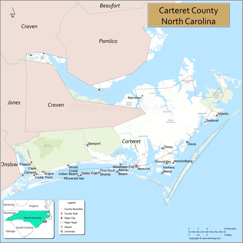
About Carteret County Map, North Carolina: The map showing the county boundary, county seat, major cities, highways, water bodies and neighbouring counties.
Related North Carolina Links
About Carteret County, North Carolina
Carteret County is a county located in the U.S. state of North Carolina. It's county seat is Beaufort. As per 2020 census, the population of Carteret County is 68541 people and population density is square miles. According to the United States Census Bureau, the county has a total area of 1,341 sq mi (3,473 km2). Carteret County was established on 1722.
Carteret County Facts
| Continent | North America |
| Country | United States |
| State | North Carolina |
| County Seat | Beaufort |
| Largest City/Town | Morehead City |
| Established | 1722 |
| Total Area | 1,341 sq mi (3,472 sq km) |
| Land Area | 506 sq mi (1,311 sq km) |
| Water Area | 835 sq mi (2,161 sq km) |
| Population | 67,686 (Census 2020) |
| Population Density | 134 people per sq mi |
| Time Zone | Eastern Time Zone (ET) |
| Major Highways | US-70, NC-24, NC-58, NC-101 |
| Major Rivers | Newport River, White Oak River |
| Neighboring Counties | Craven County, Jones County, Onslow County |
| Famous For | Crystal Coast, barrier islands, beaches, maritime history |
| Top Attractions | Cape Lookout National Seashore, Fort Macon State Park, Atlantic Beach, Beaufort Historic District |
| Official Website | Official Website |
About Carteret County, North Carolina
Carteret County is located in the eastern part of North Carolina, in the state of the United States, and was established in 1722. The county seat is Beaufort, while Morehead City is the largest town. The county lies along the Atlantic Ocean and is known for its beautiful beaches, barrier islands, and strong maritime heritage along the Crystal Coast.
Cities and Towns in Carteret County, North Carolina
| City/Town | Population (Census 2020) | Latitude & Longitude |
|---|---|---|
| Beaufort (county seat) | 4,464 | 34.7182°N, 76.6638°W |
| Morehead City | 9,556 | 34.7229°N, 76.7260°W |
| Atlantic Beach | 1,364 | 34.6999°N, 76.7402°W |
| Emerald Isle | 3,847 | 34.6779°N, 76.9508°W |
| Cape Carteret | 2,126 | 34.6902°N, 77.0647°W |
| Cedar Point | 1,866 | 34.6866°N, 77.0797°W |
| Indian Beach | 223 | 34.6895°N, 76.8708°W |
| Pine Knoll Shores | 1,334 | 34.6932°N, 76.8133°W |
| Newport | 4,364 | 34.7871°N, 76.8583°W |
| Bogue (CDP) | 800 | 34.7000°N, 77.0000°W |
| Harkers Island (CDP) | 1,200 | 34.7000°N, 76.5500°W |
| Stella (CDP) | 1,000 | 34.7400°N, 77.1000°W |
| Mill Creek (CDP) | 900 | 34.7800°N, 76.9500°W |
Golf Courses in Carteret County, North Carolina
| Golf Course | Location | Latitude & Longitude |
|---|---|---|
| Crystal Coast Country Club | Pine Knoll Shores | 34.6940°N, 76.8138°W |
| Brandywine Bay Golf Club | Morehead City | 34.7600°N, 76.7300°W |
| Star Hill Golf Club | Cape Carteret | 34.7100°N, 77.0600°W |
Roads and Highways in Carteret County, North Carolina
Carteret County is connected by coastal highways that link beach communities and inland areas.
- US-70 – main route connecting Morehead City to New Bern and inland North Carolina
- NC-24 – runs west connecting the county to Jacksonville
- NC-58 – coastal highway linking Emerald Isle and Atlantic Beach
- NC-101 – connects Beaufort to Havelock
Neighboring Counties of Carteret County
- Craven County (north)
- Jones County (northwest)
- Onslow County (west)
Top Attractions in Carteret County, North Carolina
The county is a major destination for beaches, history, and coastal recreation.
- Cape Lookout National Seashore – pristine barrier islands with lighthouse and wild horses
- Fort Macon State Park – historic fort with beaches and scenic views
- Atlantic Beach – popular beach destination with family-friendly attractions
- Emerald Isle – scenic beach known for fishing, boating, and relaxation
- Beaufort Historic District – charming waterfront town with historic homes
- North Carolina Maritime Museum – exhibits on coastal history and shipwrecks
- Shackleford Banks – barrier island known for wild horses and natural beauty
Distance from Carteret County to Nearby Cities
- Beaufort to New Bern – 40 mi (64 km)
- Beaufort to Jacksonville – 45 mi (72 km)
- Beaufort to Wilmington – 95 mi (153 km)
- Beaufort to Raleigh – 140 mi (225 km)
- Beaufort to Greenville – 85 mi (137 km)
FAQs about Carteret County
Carteret County is located in eastern North Carolina along the Atlantic Ocean on the Crystal Coast.
The population of Carteret County is 67,686 according to the 2020 Census.
Carteret County is known for its beaches, barrier islands, maritime history, and coastal tourism.
Major highways include US-70, NC-24, NC-58, and NC-101.
Yes, Carteret County has golf courses including Crystal Coast Country Club, Brandywine Bay Golf Club, and Star Hill Golf Club.
- Alamance County Map
- Alexander County Map
- Alleghany County Map
- Anson County Map
- Ashe County Map
- Avery County Map
- Beaufort County Map
- Bertie County Map
- Bladen County Map
- Brunswick County Map
- Buncombe County Map
- Burke County Map
- Cabarrus County Map
- Caldwell County Map
- Camden County Map
- Carteret County Map
- Caswell County Map
- Catawba County Map
- Chatham County Map
- Cherokee County Map
- Chowan County Map
- Clay County Map
- Cleveland County Map
- Columbus County Map
- Craven County Map
- Cumberland County Map
- Currituck County Map
- Dare County Map
- Davidson County Map
- Davie County Map
- Duplin County Map
- Durham County Map
- Edgecombe County Map
- Forsyth County Map
- Franklin County Map
- Gaston County Map
- Gates County Map
- Graham County Map
- Granville County Map
- Greene County Map
- Guilford County Map
- Halifax County Map
- Harnett County Map
- Haywood County Map
- Henderson County Map
- Hertford County Map
- Hoke County Map
- Hyde County Map
- Iredell County Map
- Jackson County Map
- Johnston County Map
- Jones County Map
- Lee County Map
- Lenoir County Map
- Lincoln County Map
- McDowell County Map
- Macon County Map
- Madison County Map
- Martin County Map
- Mecklenburg County Map
- Mitchell County Map
- Montgomery County Map
- Moore County Map
- Nash County Map
- New Hanover County Map
- Northampton County Map
- Onslow County Map
- Orange County Map
- Pamlico County Map
- Pasquotank County Map
- Pender County Map
- Perquimans County Map
- Person County Map
- Pitt County Map
- Polk County Map
- Randolph County Map
- Richmond County Map
- Robeson County Map
- Rockingham County Map
- Rowan County Map
- Rutherford County Map
- Sampson County Map
- Scotland County Map
- Stanly County Map
- Stokes County Map
- Surry County Map
- Swain County Map
- Transylvania County Map
- Tyrrell County Map
- Union County Map
- Vance County Map
- Wake County Map
- Warren County Map
- Washington County Map
- Watauga County Map
- Wayne County Map
- Wilkes County Map
- Wilson County Map
- Yadkin County Map
- Yancey County Map
- Alabama Counties
- Alaska boroughs
- Arizona Counties
- Arkansas Counties
- California County Map
- Colorado Counties
- Connecticut Counties
- Delaware Counties
- Florida County Map
- Georgia County Map
- Hawaii Counties
- Idaho Counties
- Illinois Counties
- Indiana Counties
- Iowa Counties
- Kansas Counties
- Kentucky Counties
- Louisiana Counties
- Maine Counties
- Maryland Counties
- Massachusetts Counties
- Michigan County Map
- Minnesota Counties
- Mississippi Counties
- Missouri Counties
- Montana Counties
- Nebraska Counties
- Nevada Counties
- New York Counties
- New Hampshire Counties
- New Jersey Counties
- New Mexico Counties
- North Carolina Counties
- North Dakota Counties
- Ohio County Map
- Oklahoma Counties
- Oregon Counties
- Pennsylvania Counties
- Rhode Island Counties
- South Carolina Counties
- South Dakota Counties
- Map of Tennessee
- Texas County Map
- Utah Counties
- Vermont Counties
- Virginia Counties
- Washington Counties
- West Virginia Counties
- Wisconsin Counties
- Wyoming Counties