Map of Northampton County - Northampton County is a county located in the U.S. state of North Carolina. Northampton County Map showing cities, highways, important places and water bodies. Get Where is Northampton County located in the map, major cities in Northampton county, population, areas, and places of interest.
Map of Northampton County, North Carolina
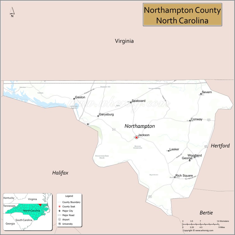
About Northampton County Map, North Carolina: The map showing the county boundary, county seat, major cities, highways, water bodies and neighbouring counties.
Related North Carolina Links
About Northampton County, North Carolina
Northampton County is a county located in the U.S. state of North Carolina. It's county seat is Jackson. As per 2020 census, the population of Northampton County is 17129 people and population density is square miles. According to the United States Census Bureau, the county has a total area of 551 sq mi (1,427 km2). Northampton County was established on 1741.
Northampton County Facts
| Continent | North America |
| Country | United States |
| State | North Carolina |
| County Seat | Jackson |
| Largest City/Town | Roanoke Rapids (partly in Halifax County) |
| Established | 1741 |
| Total Area | 551 sq mi (1,427 sq km) |
| Land Area | 536 sq mi (1,388 sq km) |
| Water Area | 15 sq mi (39 sq km) |
| Population | 17,471 (Census 2020) |
| Population Density | 33 people per sq mi |
| Time Zone | Eastern Time Zone (ET) |
| Major Highways | I-95, US-158, US-301, NC-46 |
| Major Rivers | Roanoke River |
| Neighboring Counties | Halifax County, Bertie County, Hertford County, Warren County, Greensville County (VA), Southampton County (VA) |
| Famous For | Roanoke River, rural landscapes, historic sites |
| Top Attractions | Roanoke River, Lake Gaston, Northampton County Museum, rural countryside |
| Official Website | Official Website |
About Northampton County, North Carolina
Northampton County is located in the northeastern part of North Carolina, in the state of the United States, and was established in 1741. The county seat is Jackson, while part of Roanoke Rapids extends into the county as its largest community. The county lies along the Roanoke River near the Virginia border and is known for its rural landscapes, historic heritage, and access to Lake Gaston.
Cities and Towns in Northampton County, North Carolina
| City/Town | Population (Census 2020) | Latitude & Longitude |
|---|---|---|
| Jackson (county seat) | 500 | 36.3900°N, 77.4200°W |
| Rich Square | 900 | 36.2800°N, 77.2900°W |
| Woodland | 800 | 36.3300°N, 77.2000°W |
| Seaboard | 600 | 36.4900°N, 77.4300°W |
| Conway | 800 | 36.4300°N, 77.2200°W |
| Garysburg | 1,000 | 36.4500°N, 77.5500°W |
| Gaston | 1,200 | 36.5000°N, 77.6500°W |
| Margarettsville | 100 | 36.5000°N, 77.3000°W |
| Roanoke Rapids (partly in Halifax County) | 15,000+ | 36.4600°N, 77.6500°W |
Golf Courses in Northampton County, North Carolina
| Golf Course | Location | Latitude & Longitude |
|---|---|---|
| Chowan Golf & Country Club (nearby) | Lake Gaston area | 36.5000°N, 77.9000°W |
Roads and Highways in Northampton County, North Carolina
Northampton County is connected by highways serving northeastern North Carolina and southern Virginia.
- I-95 – major interstate running north–south through the county
- US-158 – connects the county to Roanoke Rapids and Murfreesboro
- US-301 – parallels I-95 through the region
- NC-46 – provides local access across the county
Neighboring Counties of Northampton County
- Halifax County (southwest)
- Bertie County (east)
- Hertford County (southeast)
- Warren County (west)
- Greensville County, Virginia (north)
- Southampton County, Virginia (northeast)
Top Attractions in Northampton County, North Carolina
The county offers natural beauty and historical sites.
- Roanoke River – fishing, boating, and scenic views
- Lake Gaston – popular for water recreation and vacation homes
- Northampton County Museum – exhibits on local history
- Historic rural communities – small towns with historic charm
- Local farms and countryside – agricultural landscapes
Distance from Northampton County to Nearby Cities
- Jackson to Roanoke Rapids – 10 mi (16 km)
- Jackson to Rocky Mount – 50 mi (80 km)
- Jackson to Raleigh – 100 mi (161 km)
- Jackson to Richmond, VA – 80 mi (129 km)
- Jackson to Norfolk, VA – 110 mi (177 km)
FAQs about Northampton County
Northampton County is located in northeastern North Carolina along the Virginia border.
The population of Northampton County is 17,471 according to the 2020 Census.
Northampton County is known for the Roanoke River, Lake Gaston, and its rural landscapes.
Major highways include I-95, US-158, US-301, and NC-46.
There are limited golf options within Northampton County, but nearby areas around Lake Gaston offer courses.
- Alamance County Map
- Alexander County Map
- Alleghany County Map
- Anson County Map
- Ashe County Map
- Avery County Map
- Beaufort County Map
- Bertie County Map
- Bladen County Map
- Brunswick County Map
- Buncombe County Map
- Burke County Map
- Cabarrus County Map
- Caldwell County Map
- Camden County Map
- Carteret County Map
- Caswell County Map
- Catawba County Map
- Chatham County Map
- Cherokee County Map
- Chowan County Map
- Clay County Map
- Cleveland County Map
- Columbus County Map
- Craven County Map
- Cumberland County Map
- Currituck County Map
- Dare County Map
- Davidson County Map
- Davie County Map
- Duplin County Map
- Durham County Map
- Edgecombe County Map
- Forsyth County Map
- Franklin County Map
- Gaston County Map
- Gates County Map
- Graham County Map
- Granville County Map
- Greene County Map
- Guilford County Map
- Halifax County Map
- Harnett County Map
- Haywood County Map
- Henderson County Map
- Hertford County Map
- Hoke County Map
- Hyde County Map
- Iredell County Map
- Jackson County Map
- Johnston County Map
- Jones County Map
- Lee County Map
- Lenoir County Map
- Lincoln County Map
- McDowell County Map
- Macon County Map
- Madison County Map
- Martin County Map
- Mecklenburg County Map
- Mitchell County Map
- Montgomery County Map
- Moore County Map
- Nash County Map
- New Hanover County Map
- Northampton County Map
- Onslow County Map
- Orange County Map
- Pamlico County Map
- Pasquotank County Map
- Pender County Map
- Perquimans County Map
- Person County Map
- Pitt County Map
- Polk County Map
- Randolph County Map
- Richmond County Map
- Robeson County Map
- Rockingham County Map
- Rowan County Map
- Rutherford County Map
- Sampson County Map
- Scotland County Map
- Stanly County Map
- Stokes County Map
- Surry County Map
- Swain County Map
- Transylvania County Map
- Tyrrell County Map
- Union County Map
- Vance County Map
- Wake County Map
- Warren County Map
- Washington County Map
- Watauga County Map
- Wayne County Map
- Wilkes County Map
- Wilson County Map
- Yadkin County Map
- Yancey County Map
- Alabama Counties
- Alaska boroughs
- Arizona Counties
- Arkansas Counties
- California County Map
- Colorado Counties
- Connecticut Counties
- Delaware Counties
- Florida County Map
- Georgia County Map
- Hawaii Counties
- Idaho Counties
- Illinois Counties
- Indiana Counties
- Iowa Counties
- Kansas Counties
- Kentucky Counties
- Louisiana Counties
- Maine Counties
- Maryland Counties
- Massachusetts Counties
- Michigan County Map
- Minnesota Counties
- Mississippi Counties
- Missouri Counties
- Montana Counties
- Nebraska Counties
- Nevada Counties
- New York Counties
- New Hampshire Counties
- New Jersey Counties
- New Mexico Counties
- North Carolina Counties
- North Dakota Counties
- Ohio County Map
- Oklahoma Counties
- Oregon Counties
- Pennsylvania Counties
- Rhode Island Counties
- South Carolina Counties
- South Dakota Counties
- Map of Tennessee
- Texas County Map
- Utah Counties
- Vermont Counties
- Virginia Counties
- Washington Counties
- West Virginia Counties
- Wisconsin Counties
- Wyoming Counties