Map of Anson County - Anson County is a county located in the U.S. state of North Carolina. Anson County Map showing cities, highways, important places and water bodies. Get Where is Anson County located in the map, major cities in Anson county, population, areas, and places of interest.
Map of Anson County, North Carolina
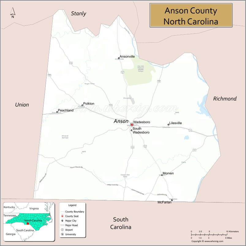
About Anson County Map, North Carolina: The map showing the county boundary, county seat, major cities, highways, water bodies and neighbouring counties.
Related North Carolina Links
About Anson County, North Carolina
Anson County is a county located in the U.S. state of North Carolina. It's county seat is Wadesboro. As per 2020 census, the population of Anson County is 22060 people and population density is square miles. According to the United States Census Bureau, the county has a total area of 537 sq mi (1,391 km2). Anson County was established on 1750.
Anson County Facts
| Continent | North America |
| Country | United States |
| State | North Carolina |
| County Seat | Wadesboro |
| Largest City/Town | Wadesboro |
| Established | 1750 |
| Total Area | 536 sq mi (1,388 sq km) |
| Land Area | 531 sq mi (1,376 sq km) |
| Water Area | 5 sq mi (13 sq km) |
| Population | 22,055 (Census 2020) |
| Population Density | 41 people per sq mi |
| Time Zone | Eastern Time Zone (ET) |
| Major Highways | US-52, US-74, US-74 Bypass, NC-109, NC-742 |
| Major Rivers | Pee Dee River, Rocky River |
| Neighboring Counties | Richmond County, Union County, Stanly County, Montgomery County, Chesterfield County (SC) |
| Famous For | Historic Wadesboro, Pee Dee River, rural landscapes, agriculture |
| Top Attractions | Pee Dee National Wildlife Refuge, Little Park, Wadesboro Historic District, Lockhart-Taylor Center |
| Official Website | Official Website |
About Anson County, North Carolina
Anson County is located in the south-central part of North Carolina, in the state of the United States, and was established in 1750. The county seat is Wadesboro, which is also the largest town. The county sits along the Pee Dee River and features a mix of farmland, forests, and small communities with deep historical roots.
Cities and Towns in Anson County, North Carolina
| City/Town | Population (Census 2020) | Latitude & Longitude |
|---|---|---|
| Wadesboro (county seat) | 5,008 | 34.9682°N, 80.0767°W |
| Lilesville | 568 | 34.9688°N, 79.9853°W |
| Morven | 444 | 34.8652°N, 80.0148°W |
| Polkton | 3,516 | 35.0046°N, 80.1998°W |
| Ansonville | 459 | 35.1040°N, 80.1156°W |
| Peachland | 390 | 34.9930°N, 80.2643°W |
| Burnsville (CDP) | 2,000 | 35.1203°N, 80.0403°W |
| White Store (CDP) | 91 | 35.0568°N, 80.1562°W |
Golf Courses in Anson County, North Carolina
| Golf Course | Location | Latitude & Longitude |
|---|---|---|
| Twin Valley Golf Club | Wadesboro | 34.9647°N, 80.1056°W |
Roads and Highways in Anson County, North Carolina
Anson County is well connected by major highways that link it to Charlotte and surrounding regions.
- US-74 – east–west corridor connecting Charlotte to Wilmington through the county
- US-52 – runs north–south linking Wadesboro with Winston-Salem and South Carolina
- NC-109 – connects Wadesboro to Mount Gilead and Denton
- NC-742 – links southern and central parts of the county
Neighboring Counties of Anson County
- Montgomery County (north)
- Stanly County (northwest)
- Union County (west)
- Chesterfield County, South Carolina (south)
- Richmond County (east)
Top Attractions in Anson County, North Carolina
The county offers a mix of nature, history, and small-town charm.
- Pee Dee National Wildlife Refuge – great spot for birdwatching, hiking, and nature photography
- Little Park – local favorite park in Wadesboro with walking paths and picnic areas
- Wadesboro Historic District – features historic homes and buildings with Southern charm
- Lockhart-Taylor Center – cultural venue hosting events, exhibits, and performances
- Pee Dee River – popular for fishing, kayaking, and scenic views
- Anson County Historical Society Museum – preserves local history and heritage
Distance from Anson County to Nearby Cities
- Wadesboro to Charlotte – 55 mi (89 km)
- Wadesboro to Rockingham – 25 mi (40 km)
- Wadesboro to Monroe – 40 mi (64 km)
- Wadesboro to Columbia, SC – 80 mi (129 km)
- Wadesboro to Fayetteville – 95 mi (153 km)
FAQs about Anson County
Anson County is located in south-central North Carolina along the South Carolina border.
The population of Anson County is 22,055 according to the 2020 Census.
Anson County is known for its historic towns, Pee Dee River, agriculture, and natural landscapes.
Major highways include US-52, US-74, NC-109, and NC-742.
Yes, Twin Valley Golf Club in Wadesboro is a notable golf course in the county.
- Alamance County Map
- Alexander County Map
- Alleghany County Map
- Anson County Map
- Ashe County Map
- Avery County Map
- Beaufort County Map
- Bertie County Map
- Bladen County Map
- Brunswick County Map
- Buncombe County Map
- Burke County Map
- Cabarrus County Map
- Caldwell County Map
- Camden County Map
- Carteret County Map
- Caswell County Map
- Catawba County Map
- Chatham County Map
- Cherokee County Map
- Chowan County Map
- Clay County Map
- Cleveland County Map
- Columbus County Map
- Craven County Map
- Cumberland County Map
- Currituck County Map
- Dare County Map
- Davidson County Map
- Davie County Map
- Duplin County Map
- Durham County Map
- Edgecombe County Map
- Forsyth County Map
- Franklin County Map
- Gaston County Map
- Gates County Map
- Graham County Map
- Granville County Map
- Greene County Map
- Guilford County Map
- Halifax County Map
- Harnett County Map
- Haywood County Map
- Henderson County Map
- Hertford County Map
- Hoke County Map
- Hyde County Map
- Iredell County Map
- Jackson County Map
- Johnston County Map
- Jones County Map
- Lee County Map
- Lenoir County Map
- Lincoln County Map
- McDowell County Map
- Macon County Map
- Madison County Map
- Martin County Map
- Mecklenburg County Map
- Mitchell County Map
- Montgomery County Map
- Moore County Map
- Nash County Map
- New Hanover County Map
- Northampton County Map
- Onslow County Map
- Orange County Map
- Pamlico County Map
- Pasquotank County Map
- Pender County Map
- Perquimans County Map
- Person County Map
- Pitt County Map
- Polk County Map
- Randolph County Map
- Richmond County Map
- Robeson County Map
- Rockingham County Map
- Rowan County Map
- Rutherford County Map
- Sampson County Map
- Scotland County Map
- Stanly County Map
- Stokes County Map
- Surry County Map
- Swain County Map
- Transylvania County Map
- Tyrrell County Map
- Union County Map
- Vance County Map
- Wake County Map
- Warren County Map
- Washington County Map
- Watauga County Map
- Wayne County Map
- Wilkes County Map
- Wilson County Map
- Yadkin County Map
- Yancey County Map
- Alabama Counties
- Alaska boroughs
- Arizona Counties
- Arkansas Counties
- California County Map
- Colorado Counties
- Connecticut Counties
- Delaware Counties
- Florida County Map
- Georgia County Map
- Hawaii Counties
- Idaho Counties
- Illinois Counties
- Indiana Counties
- Iowa Counties
- Kansas Counties
- Kentucky Counties
- Louisiana Counties
- Maine Counties
- Maryland Counties
- Massachusetts Counties
- Michigan County Map
- Minnesota Counties
- Mississippi Counties
- Missouri Counties
- Montana Counties
- Nebraska Counties
- Nevada Counties
- New York Counties
- New Hampshire Counties
- New Jersey Counties
- New Mexico Counties
- North Carolina Counties
- North Dakota Counties
- Ohio County Map
- Oklahoma Counties
- Oregon Counties
- Pennsylvania Counties
- Rhode Island Counties
- South Carolina Counties
- South Dakota Counties
- Map of Tennessee
- Texas County Map
- Utah Counties
- Vermont Counties
- Virginia Counties
- Washington Counties
- West Virginia Counties
- Wisconsin Counties
- Wyoming Counties