Map of Mitchell County - Mitchell County is a county located in the U.S. state of North Carolina. Mitchell County Map showing cities, highways, important places and water bodies. Get Where is Mitchell County located in the map, major cities in Mitchell county, population, areas, and places of interest.
Map of Mitchell County, North Carolina
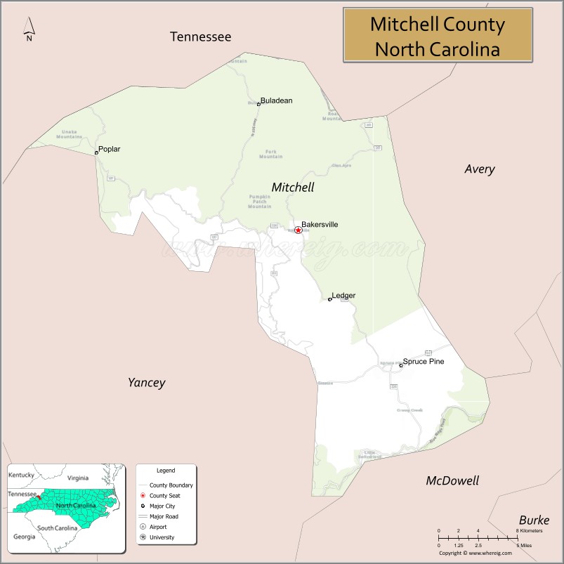
About Mitchell County Map, North Carolina: The map showing the county boundary, county seat, major cities, highways, water bodies and neighbouring counties.
Related North Carolina Links
About Mitchell County, North Carolina
Mitchell County is a county located in the U.S. state of North Carolina. It's county seat is Bakersville. As per 2020 census, the population of Mitchell County is 14963 people and population density is square miles. According to the United States Census Bureau, the county has a total area of 222 sq mi (575 km2). Mitchell County was established on 1861.
Mitchell County Facts
| Continent | North America |
| Country | United States |
| State | North Carolina |
| County Seat | Bakersville |
| Largest City/Town | Spruce Pine |
| Established | 1861 |
| Total Area | 222 sq mi (575 sq km) |
| Land Area | 221 sq mi (572 sq km) |
| Water Area | 1 sq mi (3 sq km) |
| Population | 14,903 (Census 2020) |
| Population Density | 67 people per sq mi |
| Time Zone | Eastern Time Zone (ET) |
| Major Highways | US-19E, NC-226, NC-261 |
| Major Rivers | Toe River |
| Neighboring Counties | Avery County, Yancey County, McDowell County, Carter County (TN) |
| Famous For | Gem and mineral mining, Blue Ridge Mountains, Spruce Pine quartz |
| Top Attractions | Blue Ridge Parkway nearby, Roan Mountain, Penland School of Craft, Emerald Village |
| Official Website | Official Website |
About Mitchell County, North Carolina
Mitchell County is located in the western part of North Carolina, in the state of the United States, and was established in 1861. The county seat is Bakersville, while Spruce Pine is the largest town. The county lies in the Blue Ridge Mountains along the Tennessee border and is known for its rich deposits of quartz and minerals, as well as its scenic mountain landscapes and artisan culture.
Cities and Towns in Mitchell County, North Carolina
| City/Town | Population (Census 2020) | Latitude & Longitude |
|---|---|---|
| Bakersville (county seat) | 464 | 36.0157°N, 82.1585°W |
| Spruce Pine | 2,285 | 35.9154°N, 82.0643°W |
| Ledger (CDP) | 500 | 36.0200°N, 82.1000°W |
| Red Hill (CDP) | 400 | 35.9000°N, 82.0700°W |
| Estatoe (CDP) | 300 | 35.9100°N, 82.0800°W |
Golf Courses in Mitchell County, North Carolina
| Golf Course | Location | Latitude & Longitude |
|---|---|---|
| Grassy Creek Golf & Country Club (nearby) | Spruce Pine area | 35.9200°N, 82.0600°W |
Roads and Highways in Mitchell County, North Carolina
Mitchell County is connected by scenic mountain roads serving western North Carolina.
- US-19E – main route connecting the county to Burnsville and Tennessee
- NC-226 – scenic highway through the mountains
- NC-261 – connects the county to Roan Mountain and surrounding areas
Neighboring Counties of Mitchell County
- Avery County (north)
- Carter County, Tennessee (northwest)
- Yancey County (south)
- McDowell County (southeast)
Top Attractions in Mitchell County, North Carolina
The county is known for its natural beauty, arts, and mining heritage.
- Blue Ridge Parkway (nearby) – scenic drive with mountain views
- Roan Mountain – hiking, rhododendron gardens, and panoramic vistas
- Penland School of Craft – renowned arts and crafts education center
- Emerald Village – historic gem mining area open to visitors
- Toe River – fishing, kayaking, and scenic surroundings
- Spruce Pine mining district – source of high-quality quartz used worldwide
Distance from Mitchell County to Nearby Cities
- Spruce Pine to Asheville – 60 mi (97 km)
- Spruce Pine to Johnson City, TN – 45 mi (72 km)
- Spruce Pine to Boone – 50 mi (80 km)
- Spruce Pine to Charlotte – 120 mi (193 km)
- Spruce Pine to Raleigh – 200 mi (322 km)
FAQs about Mitchell County
Mitchell County is located in western North Carolina along the Tennessee border in the Blue Ridge Mountains.
The population of Mitchell County is 14,903 according to the 2020 Census.
Mitchell County is known for its quartz mining, mountain scenery, and artisan culture.
Major highways include US-19E, NC-226, and NC-261.
There are limited golf options within Mitchell County, but nearby areas offer courses such as Grassy Creek Golf & Country Club.
- Alamance County Map
- Alexander County Map
- Alleghany County Map
- Anson County Map
- Ashe County Map
- Avery County Map
- Beaufort County Map
- Bertie County Map
- Bladen County Map
- Brunswick County Map
- Buncombe County Map
- Burke County Map
- Cabarrus County Map
- Caldwell County Map
- Camden County Map
- Carteret County Map
- Caswell County Map
- Catawba County Map
- Chatham County Map
- Cherokee County Map
- Chowan County Map
- Clay County Map
- Cleveland County Map
- Columbus County Map
- Craven County Map
- Cumberland County Map
- Currituck County Map
- Dare County Map
- Davidson County Map
- Davie County Map
- Duplin County Map
- Durham County Map
- Edgecombe County Map
- Forsyth County Map
- Franklin County Map
- Gaston County Map
- Gates County Map
- Graham County Map
- Granville County Map
- Greene County Map
- Guilford County Map
- Halifax County Map
- Harnett County Map
- Haywood County Map
- Henderson County Map
- Hertford County Map
- Hoke County Map
- Hyde County Map
- Iredell County Map
- Jackson County Map
- Johnston County Map
- Jones County Map
- Lee County Map
- Lenoir County Map
- Lincoln County Map
- McDowell County Map
- Macon County Map
- Madison County Map
- Martin County Map
- Mecklenburg County Map
- Mitchell County Map
- Montgomery County Map
- Moore County Map
- Nash County Map
- New Hanover County Map
- Northampton County Map
- Onslow County Map
- Orange County Map
- Pamlico County Map
- Pasquotank County Map
- Pender County Map
- Perquimans County Map
- Person County Map
- Pitt County Map
- Polk County Map
- Randolph County Map
- Richmond County Map
- Robeson County Map
- Rockingham County Map
- Rowan County Map
- Rutherford County Map
- Sampson County Map
- Scotland County Map
- Stanly County Map
- Stokes County Map
- Surry County Map
- Swain County Map
- Transylvania County Map
- Tyrrell County Map
- Union County Map
- Vance County Map
- Wake County Map
- Warren County Map
- Washington County Map
- Watauga County Map
- Wayne County Map
- Wilkes County Map
- Wilson County Map
- Yadkin County Map
- Yancey County Map
- Alabama Counties
- Alaska boroughs
- Arizona Counties
- Arkansas Counties
- California County Map
- Colorado Counties
- Connecticut Counties
- Delaware Counties
- Florida County Map
- Georgia County Map
- Hawaii Counties
- Idaho Counties
- Illinois Counties
- Indiana Counties
- Iowa Counties
- Kansas Counties
- Kentucky Counties
- Louisiana Counties
- Maine Counties
- Maryland Counties
- Massachusetts Counties
- Michigan County Map
- Minnesota Counties
- Mississippi Counties
- Missouri Counties
- Montana Counties
- Nebraska Counties
- Nevada Counties
- New York Counties
- New Hampshire Counties
- New Jersey Counties
- New Mexico Counties
- North Carolina Counties
- North Dakota Counties
- Ohio County Map
- Oklahoma Counties
- Oregon Counties
- Pennsylvania Counties
- Rhode Island Counties
- South Carolina Counties
- South Dakota Counties
- Map of Tennessee
- Texas County Map
- Utah Counties
- Vermont Counties
- Virginia Counties
- Washington Counties
- West Virginia Counties
- Wisconsin Counties
- Wyoming Counties