Map of Edgecombe County - Edgecombe County is a county located in the U.S. state of North Carolina. Edgecombe County Map showing cities, highways, important places and water bodies. Get Where is Edgecombe County located in the map, major cities in Edgecombe county, population, areas, and places of interest.
Map of Edgecombe County, North Carolina
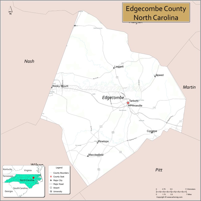
About Edgecombe County Map, North Carolina: The map showing the county boundary, county seat, major cities, highways, water bodies and neighbouring counties.
Related North Carolina Links
About Edgecombe County, North Carolina
Edgecombe County is a county located in the U.S. state of North Carolina. It's county seat is Tarboro. As per 2020 census, the population of Edgecombe County is 48359 people and population density is square miles. According to the United States Census Bureau, the county has a total area of 507 sq mi (1,313 km2). Edgecombe County was established on 1741.
Edgecombe County Facts
| Continent | North America |
| Country | United States |
| State | North Carolina |
| County Seat | Tarboro |
| Largest City/Town | Rocky Mount (partly in Nash County) |
| Established | 1741 |
| Total Area | 507 sq mi (1,313 sq km) |
| Land Area | 505 sq mi (1,308 sq km) |
| Water Area | 2 sq mi (5 sq km) |
| Population | 48,900 (Census 2020) |
| Population Density | 97 people per sq mi |
| Time Zone | Eastern Time Zone (ET) |
| Major Highways | US-64, US-258, NC-33, NC-43, NC-97 |
| Major Rivers | Tar River |
| Neighboring Counties | Nash County, Halifax County, Martin County, Pitt County, Wilson County |
| Famous For | Historic Tarboro, agriculture, Rocky Mount connection |
| Top Attractions | Tarboro Historic District, Edgecombe County Veterans Military Museum, Braswell Memorial Library, Tar River |
| Official Website | Official Website |
About Edgecombe County, North Carolina
Edgecombe County is located in the eastern part of North Carolina, in the state of the United States, and was established in 1741. The county seat is Tarboro, while part of Rocky Mount extends into the county and is its largest urban area. The county lies along the Tar River in the coastal plain region and is known for its historic sites, agriculture, and cultural heritage.
Cities and Towns in Edgecombe County, North Carolina
| City/Town | Population (Census 2020) | Latitude & Longitude |
|---|---|---|
| Tarboro (county seat) | 10,721 | 35.8968°N, 77.5358°W |
| Rocky Mount (partly in Nash County) | 54,341 (total city) | 35.9382°N, 77.7905°W |
| Princeville | 1,940 | 35.8896°N, 77.5336°W |
| Macclesfield | 458 | 35.7535°N, 77.6530°W |
| Whitakers (partly in Nash County) | 744 | 36.1018°N, 77.7130°W |
| Conetoe | 227 | 35.8177°N, 77.4544°W |
| Pinetops (partly in Pitt County) | 1,413 | 35.7871°N, 77.6394°W |
| Speed | 60 | 35.9660°N, 77.4400°W |
| Sharpsburg (partly in Nash County) | 2,000 | 35.8700°N, 77.8300°W |
Golf Courses in Edgecombe County, North Carolina
| Golf Course | Location | Latitude & Longitude |
|---|---|---|
| Benvenue Country Club | Rocky Mount | 35.9600°N, 77.8000°W |
| Belmont Lake Golf Club | Rocky Mount | 35.9500°N, 77.7500°W |
Roads and Highways in Edgecombe County, North Carolina
Edgecombe County is connected by major highways serving eastern North Carolina.
- US-64 – major east–west route connecting the county to Raleigh and the coast
- US-258 – runs north–south linking Tarboro to Kinston and Virginia
- NC-33 – connects Tarboro to Greenville and Rocky Mount
- NC-43 – links the county to Greenville and Wilson
- NC-97 – provides local access across the county
Neighboring Counties of Edgecombe County
- Halifax County (north)
- Nash County (west)
- Wilson County (southwest)
- Pitt County (south)
- Martin County (east)
Top Attractions in Edgecombe County, North Carolina
The county offers history, culture, and scenic river views.
- Tarboro Historic District – one of the oldest historic districts in North Carolina
- Princeville – one of the oldest towns incorporated by African Americans in the U.S.
- Edgecombe County Veterans Military Museum – exhibits on military history
- Braswell Memorial Library – cultural and educational center in Rocky Mount
- Tar River – scenic river for fishing and outdoor activities
- Rocky Mount Mills (nearby) – restored mill area with shops and entertainment
Distance from Edgecombe County to Nearby Cities
- Tarboro to Raleigh – 70 mi (113 km)
- Tarboro to Greenville – 25 mi (40 km)
- Tarboro to Rocky Mount – 15 mi (24 km)
- Tarboro to Wilson – 35 mi (56 km)
- Tarboro to Norfolk, VA – 120 mi (193 km)
FAQs about Edgecombe County
Edgecombe County is located in eastern North Carolina along the Tar River.
The population of Edgecombe County is 48,900 according to the 2020 Census.
Edgecombe County is known for its historic town of Tarboro, agriculture, and cultural heritage.
Major highways include US-64, US-258, NC-33, NC-43, and NC-97.
Yes, Edgecombe County has golf courses including Belmont Lake Golf Club and nearby options in Rocky Mount.
- Alamance County Map
- Alexander County Map
- Alleghany County Map
- Anson County Map
- Ashe County Map
- Avery County Map
- Beaufort County Map
- Bertie County Map
- Bladen County Map
- Brunswick County Map
- Buncombe County Map
- Burke County Map
- Cabarrus County Map
- Caldwell County Map
- Camden County Map
- Carteret County Map
- Caswell County Map
- Catawba County Map
- Chatham County Map
- Cherokee County Map
- Chowan County Map
- Clay County Map
- Cleveland County Map
- Columbus County Map
- Craven County Map
- Cumberland County Map
- Currituck County Map
- Dare County Map
- Davidson County Map
- Davie County Map
- Duplin County Map
- Durham County Map
- Edgecombe County Map
- Forsyth County Map
- Franklin County Map
- Gaston County Map
- Gates County Map
- Graham County Map
- Granville County Map
- Greene County Map
- Guilford County Map
- Halifax County Map
- Harnett County Map
- Haywood County Map
- Henderson County Map
- Hertford County Map
- Hoke County Map
- Hyde County Map
- Iredell County Map
- Jackson County Map
- Johnston County Map
- Jones County Map
- Lee County Map
- Lenoir County Map
- Lincoln County Map
- McDowell County Map
- Macon County Map
- Madison County Map
- Martin County Map
- Mecklenburg County Map
- Mitchell County Map
- Montgomery County Map
- Moore County Map
- Nash County Map
- New Hanover County Map
- Northampton County Map
- Onslow County Map
- Orange County Map
- Pamlico County Map
- Pasquotank County Map
- Pender County Map
- Perquimans County Map
- Person County Map
- Pitt County Map
- Polk County Map
- Randolph County Map
- Richmond County Map
- Robeson County Map
- Rockingham County Map
- Rowan County Map
- Rutherford County Map
- Sampson County Map
- Scotland County Map
- Stanly County Map
- Stokes County Map
- Surry County Map
- Swain County Map
- Transylvania County Map
- Tyrrell County Map
- Union County Map
- Vance County Map
- Wake County Map
- Warren County Map
- Washington County Map
- Watauga County Map
- Wayne County Map
- Wilkes County Map
- Wilson County Map
- Yadkin County Map
- Yancey County Map
- Alabama Counties
- Alaska boroughs
- Arizona Counties
- Arkansas Counties
- California County Map
- Colorado Counties
- Connecticut Counties
- Delaware Counties
- Florida County Map
- Georgia County Map
- Hawaii Counties
- Idaho Counties
- Illinois Counties
- Indiana Counties
- Iowa Counties
- Kansas Counties
- Kentucky Counties
- Louisiana Counties
- Maine Counties
- Maryland Counties
- Massachusetts Counties
- Michigan County Map
- Minnesota Counties
- Mississippi Counties
- Missouri Counties
- Montana Counties
- Nebraska Counties
- Nevada Counties
- New York Counties
- New Hampshire Counties
- New Jersey Counties
- New Mexico Counties
- North Carolina Counties
- North Dakota Counties
- Ohio County Map
- Oklahoma Counties
- Oregon Counties
- Pennsylvania Counties
- Rhode Island Counties
- South Carolina Counties
- South Dakota Counties
- Map of Tennessee
- Texas County Map
- Utah Counties
- Vermont Counties
- Virginia Counties
- Washington Counties
- West Virginia Counties
- Wisconsin Counties
- Wyoming Counties