Map of Beaufort County - Beaufort County is a county located in the U.S. state of North Carolina. Beaufort County Map showing cities, highways, important places and water bodies. Get Where is Beaufort County located in the map, major cities in Beaufort county, population, areas, and places of interest.
Map of Beaufort County, North Carolina
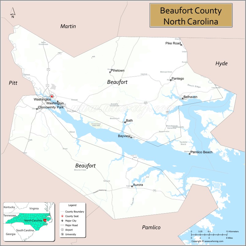
About Beaufort County Map, North Carolina: The map showing the county boundary, county seat, major cities, highways, water bodies and neighbouring counties.
Related North Carolina Links
About Beaufort County, North Carolina
Beaufort County is a county located in the U.S. state of North Carolina. It's county seat is Washington. As per 2020 census, the population of Beaufort County is 44468 people and population density is square miles. According to the United States Census Bureau, the county has a total area of 959 sq mi (2,484 km2). Beaufort County was established on 1712.
Beaufort County Facts
| Continent | North America |
| Country | United States |
| State | North Carolina |
| County Seat | Washington |
| Largest City/Town | Washington |
| Established | 1705 |
| Total Area | 958 sq mi (2,481 sq km) |
| Land Area | 828 sq mi (2,145 sq km) |
| Water Area | 130 sq mi (337 sq km) |
| Population | 44,652 (Census 2020) |
| Population Density | 54 people per sq mi |
| Time Zone | Eastern Time Zone (ET) |
| Major Highways | US-17, US-264, NC-32, NC-33, NC-99 |
| Major Rivers | Pamlico River, Pungo River, Tar River |
| Neighboring Counties | Hyde County, Pamlico County, Pitt County, Martin County, Washington County |
| Famous For | Historic Washington, waterfront views, Pamlico River, coastal plains |
| Top Attractions | Washington Waterfront, Goose Creek State Park, Historic Washington District, Pamlico River |
| Official Website | Official Website |
About Beaufort County, North Carolina
Beaufort County is located in the eastern part of North Carolina, in the state of the United States, and was established in 1705. The county seat is Washington, which is also the largest city. The county lies along the Pamlico River and features coastal plains, wetlands, and scenic waterfront communities that are important for fishing and recreation.
Cities and Towns in Beaufort County, North Carolina
| City/Town | Population (Census 2020) | Latitude & Longitude |
|---|---|---|
| Washington (county seat) | 9,744 | 35.5466°N, 77.0522°W |
| Aurora | 480 | 35.3063°N, 76.7897°W |
| Bath | 245 | 35.4760°N, 76.8116°W |
| Belhaven | 1,581 | 35.5402°N, 76.6230°W |
| Chocowinity | 820 | 35.5124°N, 77.1047°W |
| Pantego | 170 | 35.6027°N, 76.6658°W |
| Washington Park | 494 | 35.5460°N, 77.0549°W |
| River Road (CDP) | 1,200 | 35.5200°N, 77.0800°W |
| Royal (CDP) | 890 | 35.4500°N, 76.9500°W |
Golf Courses in Beaufort County, North Carolina
| Golf Course | Location | Latitude & Longitude |
|---|---|---|
| Washington Yacht & Country Club Golf Course | Washington | 35.5487°N, 77.0535°W |
| Beaufort Club Golf Course | Chocowinity | 35.5301°N, 77.0976°W |
Roads and Highways in Beaufort County, North Carolina
Beaufort County is connected by several highways that link coastal and inland regions.
- US-17 – runs north–south connecting the county to New Bern and Williamston
- US-264 – major east–west route linking Washington to Greenville and the Outer Banks region
- NC-32 – connects to Plymouth and eastern coastal areas
- NC-33 – links Washington to Greenville and Aurora
- NC-99 – provides local connections within the county
Neighboring Counties of Beaufort County
- Martin County (north)
- Washington County (northeast)
- Hyde County (east)
- Pamlico County (south)
- Pitt County (west)
Top Attractions in Beaufort County, North Carolina
The county offers coastal scenery, history, and outdoor activities.
- Washington Waterfront – scenic riverfront with shops, restaurants, and marinas
- Goose Creek State Park – hiking, kayaking, and camping in a natural setting
- Historic Bath – North Carolina’s oldest town with colonial history
- Pamlico River – ideal for boating, fishing, and sunset views
- Belhaven Waterfront – charming small-town harbor with coastal views
- North Carolina Estuarium – educational exhibits about coastal ecosystems
Distance from Beaufort County to Nearby Cities
- Washington to Greenville – 20 mi (32 km)
- Washington to New Bern – 45 mi (72 km)
- Washington to Raleigh – 110 mi (177 km)
- Washington to Wilmington – 140 mi (225 km)
- Washington to Norfolk, VA – 130 mi (209 km)
FAQs about Beaufort County
Beaufort County is located in eastern North Carolina along the Pamlico River near the Atlantic coastal plain.
The population of Beaufort County is 44,652 according to the 2020 Census.
Beaufort County is known for its waterfront communities, historic towns, and access to the Pamlico River.
Major highways include US-17, US-264, NC-32, NC-33, and NC-99.
Yes, notable courses include Washington Yacht & Country Club and Beaufort Club Golf Course.
- Alamance County Map
- Alexander County Map
- Alleghany County Map
- Anson County Map
- Ashe County Map
- Avery County Map
- Beaufort County Map
- Bertie County Map
- Bladen County Map
- Brunswick County Map
- Buncombe County Map
- Burke County Map
- Cabarrus County Map
- Caldwell County Map
- Camden County Map
- Carteret County Map
- Caswell County Map
- Catawba County Map
- Chatham County Map
- Cherokee County Map
- Chowan County Map
- Clay County Map
- Cleveland County Map
- Columbus County Map
- Craven County Map
- Cumberland County Map
- Currituck County Map
- Dare County Map
- Davidson County Map
- Davie County Map
- Duplin County Map
- Durham County Map
- Edgecombe County Map
- Forsyth County Map
- Franklin County Map
- Gaston County Map
- Gates County Map
- Graham County Map
- Granville County Map
- Greene County Map
- Guilford County Map
- Halifax County Map
- Harnett County Map
- Haywood County Map
- Henderson County Map
- Hertford County Map
- Hoke County Map
- Hyde County Map
- Iredell County Map
- Jackson County Map
- Johnston County Map
- Jones County Map
- Lee County Map
- Lenoir County Map
- Lincoln County Map
- McDowell County Map
- Macon County Map
- Madison County Map
- Martin County Map
- Mecklenburg County Map
- Mitchell County Map
- Montgomery County Map
- Moore County Map
- Nash County Map
- New Hanover County Map
- Northampton County Map
- Onslow County Map
- Orange County Map
- Pamlico County Map
- Pasquotank County Map
- Pender County Map
- Perquimans County Map
- Person County Map
- Pitt County Map
- Polk County Map
- Randolph County Map
- Richmond County Map
- Robeson County Map
- Rockingham County Map
- Rowan County Map
- Rutherford County Map
- Sampson County Map
- Scotland County Map
- Stanly County Map
- Stokes County Map
- Surry County Map
- Swain County Map
- Transylvania County Map
- Tyrrell County Map
- Union County Map
- Vance County Map
- Wake County Map
- Warren County Map
- Washington County Map
- Watauga County Map
- Wayne County Map
- Wilkes County Map
- Wilson County Map
- Yadkin County Map
- Yancey County Map
- Alabama Counties
- Alaska boroughs
- Arizona Counties
- Arkansas Counties
- California County Map
- Colorado Counties
- Connecticut Counties
- Delaware Counties
- Florida County Map
- Georgia County Map
- Hawaii Counties
- Idaho Counties
- Illinois Counties
- Indiana Counties
- Iowa Counties
- Kansas Counties
- Kentucky Counties
- Louisiana Counties
- Maine Counties
- Maryland Counties
- Massachusetts Counties
- Michigan County Map
- Minnesota Counties
- Mississippi Counties
- Missouri Counties
- Montana Counties
- Nebraska Counties
- Nevada Counties
- New York Counties
- New Hampshire Counties
- New Jersey Counties
- New Mexico Counties
- North Carolina Counties
- North Dakota Counties
- Ohio County Map
- Oklahoma Counties
- Oregon Counties
- Pennsylvania Counties
- Rhode Island Counties
- South Carolina Counties
- South Dakota Counties
- Map of Tennessee
- Texas County Map
- Utah Counties
- Vermont Counties
- Virginia Counties
- Washington Counties
- West Virginia Counties
- Wisconsin Counties
- Wyoming Counties