Map of Forsyth County - Forsyth County is a county located in the U.S. state of North Carolina. Forsyth County Map showing cities, highways, important places and water bodies. Get Where is Forsyth County located in the map, major cities in Forsyth county, population, areas, and places of interest.
Map of Forsyth County, North Carolina
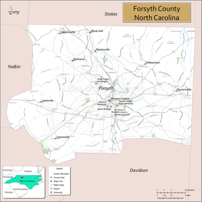
About Forsyth County Map, North Carolina: The map showing the county boundary, county seat, major cities, highways, water bodies and neighbouring counties.
Related North Carolina Links
About Forsyth County, North Carolina
Forsyth County is a county located in the U.S. state of North Carolina. It's county seat is Winston-Salem. As per 2020 census, the population of Forsyth County is 385523 people and population density is square miles. According to the United States Census Bureau, the county has a total area of 413 sq mi (1,070 km2). Forsyth County was established on 1849.
Forsyth County Facts
| Continent | North America |
| Country | United States |
| State | North Carolina |
| County Seat | Winston-Salem |
| Largest City/Town | Winston-Salem |
| Established | 1849 |
| Total Area | 413 sq mi (1,070 sq km) |
| Land Area | 408 sq mi (1,057 sq km) |
| Water Area | 5 sq mi (13 sq km) |
| Population | 382,590 (Census 2020) |
| Population Density | 938 people per sq mi |
| Time Zone | Eastern Time Zone (ET) |
| Major Highways | I-40, I-74, US-52, US-421, NC-67, NC-150 |
| Major Rivers | Yadkin River |
| Neighboring Counties | Stokes County, Rockingham County, Guilford County, Davidson County, Davie County, Yadkin County |
| Famous For | Winston-Salem, tobacco history, arts and innovation |
| Top Attractions | Old Salem Museums & Gardens, Reynolda House Museum, Pilot Mountain nearby, Wake Forest University |
| Official Website | Official Website |
About Forsyth County, North Carolina
Forsyth County is located in the north-central part of North Carolina, in the state of the United States, and was established in 1849. The county seat is Winston-Salem, which is also the largest city. The county lies in the Piedmont region and is known for its rich tobacco history, cultural institutions, and as a center for innovation and education.
Cities and Towns in Forsyth County, North Carolina
| City/Town | Population (Census 2020) | Latitude & Longitude |
|---|---|---|
| Winston-Salem (county seat) | 249,545 | 36.0999°N, 80.2442°W |
| Kernersville (partly in Guilford County) | 23,949 | 36.1199°N, 80.0736°W |
| Clemmons | 20,000 | 36.0200°N, 80.3800°W |
| Lewisville | 13,381 | 36.0990°N, 80.4100°W |
| Walkertown | 5,000 | 36.1600°N, 80.1500°W |
| Rural Hall | 3,300 | 36.2400°N, 80.2900°W |
| Tobaccoville | 2,600 | 36.2300°N, 80.3700°W |
| Belews Creek (CDP) | 1,200 | 36.2200°N, 80.0800°W |
Golf Courses in Forsyth County, North Carolina
| Golf Course | Location | Latitude & Longitude |
|---|---|---|
| Tanglewood Park Golf Courses | Clemmons | 36.0000°N, 80.3900°W |
| Reynolds Park Golf Course | Winston-Salem | 36.0900°N, 80.2500°W |
| Salem Glen Country Club | Clemmons | 36.0200°N, 80.4000°W |
Roads and Highways in Forsyth County, North Carolina
Forsyth County is well connected by highways that serve the Piedmont Triad region.
- I-40 – major east–west interstate linking Winston-Salem to Greensboro and Asheville
- I-74 – connects the county to High Point and Mount Airy
- US-52 – runs north–south through Winston-Salem
- US-421 – connects Winston-Salem to Boone and Greensboro
- NC-67 – provides access to rural communities
- NC-150 – links the county to Yadkinville and other areas
Neighboring Counties of Forsyth County
- Stokes County (north)
- Rockingham County (northeast)
- Guilford County (east)
- Davidson County (south)
- Davie County (southwest)
- Yadkin County (west)
Top Attractions in Forsyth County, North Carolina
The county offers a blend of history, arts, and outdoor recreation.
- Old Salem Museums & Gardens – historic Moravian settlement and museum
- Reynolda House Museum of American Art – art museum and historic estate
- Tanglewood Park – large park with trails, golf, and seasonal events
- Wake Forest University – major educational institution with scenic campus
- Hanes Mall – one of the largest shopping centers in North Carolina
- Nearby Pilot Mountain State Park – popular hiking and scenic views
Distance from Forsyth County to Nearby Cities
- Winston-Salem to Greensboro – 30 mi (48 km)
- Winston-Salem to Charlotte – 80 mi (129 km)
- Winston-Salem to Raleigh – 100 mi (161 km)
- Winston-Salem to Asheville – 130 mi (209 km)
- Winston-Salem to Durham – 75 mi (121 km)
FAQs about Forsyth County
Forsyth County is located in north-central North Carolina within the Piedmont Triad region.
The population of Forsyth County is 382,590 according to the 2020 Census.
Forsyth County is known for Winston-Salem, its tobacco history, and cultural institutions.
Major highways include I-40, I-74, US-52, US-421, NC-67, and NC-150.
Yes, Forsyth County has golf courses including Tanglewood Park Golf Courses and Reynolds Park Golf Course.
- Alamance County Map
- Alexander County Map
- Alleghany County Map
- Anson County Map
- Ashe County Map
- Avery County Map
- Beaufort County Map
- Bertie County Map
- Bladen County Map
- Brunswick County Map
- Buncombe County Map
- Burke County Map
- Cabarrus County Map
- Caldwell County Map
- Camden County Map
- Carteret County Map
- Caswell County Map
- Catawba County Map
- Chatham County Map
- Cherokee County Map
- Chowan County Map
- Clay County Map
- Cleveland County Map
- Columbus County Map
- Craven County Map
- Cumberland County Map
- Currituck County Map
- Dare County Map
- Davidson County Map
- Davie County Map
- Duplin County Map
- Durham County Map
- Edgecombe County Map
- Forsyth County Map
- Franklin County Map
- Gaston County Map
- Gates County Map
- Graham County Map
- Granville County Map
- Greene County Map
- Guilford County Map
- Halifax County Map
- Harnett County Map
- Haywood County Map
- Henderson County Map
- Hertford County Map
- Hoke County Map
- Hyde County Map
- Iredell County Map
- Jackson County Map
- Johnston County Map
- Jones County Map
- Lee County Map
- Lenoir County Map
- Lincoln County Map
- McDowell County Map
- Macon County Map
- Madison County Map
- Martin County Map
- Mecklenburg County Map
- Mitchell County Map
- Montgomery County Map
- Moore County Map
- Nash County Map
- New Hanover County Map
- Northampton County Map
- Onslow County Map
- Orange County Map
- Pamlico County Map
- Pasquotank County Map
- Pender County Map
- Perquimans County Map
- Person County Map
- Pitt County Map
- Polk County Map
- Randolph County Map
- Richmond County Map
- Robeson County Map
- Rockingham County Map
- Rowan County Map
- Rutherford County Map
- Sampson County Map
- Scotland County Map
- Stanly County Map
- Stokes County Map
- Surry County Map
- Swain County Map
- Transylvania County Map
- Tyrrell County Map
- Union County Map
- Vance County Map
- Wake County Map
- Warren County Map
- Washington County Map
- Watauga County Map
- Wayne County Map
- Wilkes County Map
- Wilson County Map
- Yadkin County Map
- Yancey County Map
- Alabama Counties
- Alaska boroughs
- Arizona Counties
- Arkansas Counties
- California County Map
- Colorado Counties
- Connecticut Counties
- Delaware Counties
- Florida County Map
- Georgia County Map
- Hawaii Counties
- Idaho Counties
- Illinois Counties
- Indiana Counties
- Iowa Counties
- Kansas Counties
- Kentucky Counties
- Louisiana Counties
- Maine Counties
- Maryland Counties
- Massachusetts Counties
- Michigan County Map
- Minnesota Counties
- Mississippi Counties
- Missouri Counties
- Montana Counties
- Nebraska Counties
- Nevada Counties
- New York Counties
- New Hampshire Counties
- New Jersey Counties
- New Mexico Counties
- North Carolina Counties
- North Dakota Counties
- Ohio County Map
- Oklahoma Counties
- Oregon Counties
- Pennsylvania Counties
- Rhode Island Counties
- South Carolina Counties
- South Dakota Counties
- Map of Tennessee
- Texas County Map
- Utah Counties
- Vermont Counties
- Virginia Counties
- Washington Counties
- West Virginia Counties
- Wisconsin Counties
- Wyoming Counties