Map of Ashe County - Ashe County is a county located in the U.S. state of North Carolina. Ashe County Map showing cities, highways, important places and water bodies. Get Where is Ashe County located in the map, major cities in Ashe county, population, areas, and places of interest.
Map of Ashe County, North Carolina
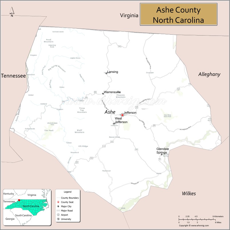
About Ashe County Map, North Carolina: The map showing the county boundary, county seat, major cities, highways, water bodies and neighbouring counties.
Related North Carolina Links
About Ashe County, North Carolina
Ashe County is a county located in the U.S. state of North Carolina. It's county seat is Jefferson. As per 2020 census, the population of Ashe County is 26711 people and population density is square miles. According to the United States Census Bureau, the county has a total area of 427 sq mi (1,106 km2). Ashe County was established on 1799.
Ashe County Facts
| Continent | North America |
| Country | United States |
| State | North Carolina |
| County Seat | Jefferson |
| Largest City/Town | West Jefferson |
| Established | 1799 |
| Total Area | 429 sq mi (1,111 sq km) |
| Land Area | 426 sq mi (1,103 sq km) |
| Water Area | 3 sq mi (8 sq km) |
| Population | 26,577 (Census 2020) |
| Population Density | 62 people per sq mi |
| Time Zone | Eastern Time Zone (ET) |
| Major Highways | US-221, US-421, NC-16, NC-88, NC-194 |
| Major Rivers | New River, South Fork New River, North Fork New River |
| Neighboring Counties | Alleghany County, Watauga County, Wilkes County, Johnson County (TN), Grayson County (VA) |
| Famous For | Blue Ridge Mountains, Mount Jefferson, Christmas tree farms, outdoor recreation |
| Top Attractions | Mount Jefferson State Natural Area, New River, Ashe County Cheese Factory, Blue Ridge Parkway |
| Official Website | Official Website |
About Ashe County, North Carolina
Ashe County is located in the northwestern part of North Carolina, in the state of the United States, and was established in 1799. The county seat is Jefferson, while West Jefferson is the largest town. The county sits in the Blue Ridge Mountains and is known for its cool climate, scenic views, and strong agricultural traditions, especially Christmas tree farming.
Cities and Towns in Ashe County, North Carolina
| City/Town | Population (Census 2020) | Latitude & Longitude |
|---|---|---|
| Jefferson (county seat) | 1,622 | 36.4204°N, 81.4743°W |
| West Jefferson | 1,299 | 36.4032°N, 81.4926°W |
| Lansing | 126 | 36.5093°N, 81.5037°W |
| Creston (CDP) | 131 | 36.4454°N, 81.6213°W |
| Fleetwood (CDP) | 236 | 36.3082°N, 81.5059°W |
| Todd (CDP, partly in Watauga County) | 2,400 | 36.3162°N, 81.5984°W |
Golf Courses in Ashe County, North Carolina
| Golf Course | Location | Latitude & Longitude |
|---|---|---|
| Mountain Aire Golf Club | West Jefferson | 36.4015°N, 81.4912°W |
| Jefferson Landing Club | Jefferson | 36.3956°N, 81.4690°W |
Roads and Highways in Ashe County, North Carolina
Ashe County is served by several highways that connect mountain towns and neighboring regions.
- US-221 – runs north–south connecting Jefferson to Boone and Virginia
- US-421 – major route linking the county to Wilkesboro and Tennessee
- NC-16 – connects Ashe County to Wilkes County and Virginia
- NC-88 – runs east–west through Jefferson and Warrensville
- NC-194 – scenic route connecting Todd and West Jefferson
Neighboring Counties of Ashe County
- Grayson County, Virginia (north)
- Alleghany County (east)
- Wilkes County (south)
- Watauga County (southwest)
- Johnson County, Tennessee (west)
Top Attractions in Ashe County, North Carolina
The county is known for mountain views, outdoor recreation, and local culture.
- Mount Jefferson State Natural Area – hiking trails with panoramic mountain views
- New River – one of the oldest rivers, popular for kayaking and fishing
- Ashe County Cheese Factory – famous local cheese maker with tours and shop
- Blue Ridge Parkway – scenic drive with overlooks and hiking opportunities
- West Jefferson Murals – vibrant public art throughout downtown
- New River State Park nearby – camping, canoeing, and wildlife viewing
Distance from Ashe County to Nearby Cities
- Jefferson to Boone – 25 mi (40 km)
- Jefferson to Wilkesboro – 30 mi (48 km)
- Jefferson to Winston-Salem – 90 mi (145 km)
- Jefferson to Charlotte – 110 mi (177 km)
- Jefferson to Bristol, TN – 70 mi (113 km)
FAQs about Ashe County
Ashe County is located in northwestern North Carolina along the borders of Virginia and Tennessee in the Blue Ridge Mountains.
The population of Ashe County is 26,577 according to the 2020 Census.
Ashe County is known for its mountain scenery, Christmas tree farms, outdoor recreation, and the New River.
Major highways include US-221, US-421, NC-16, NC-88, and NC-194.
Yes, notable golf courses include Mountain Aire Golf Club and Jefferson Landing Club.
- Alamance County Map
- Alexander County Map
- Alleghany County Map
- Anson County Map
- Ashe County Map
- Avery County Map
- Beaufort County Map
- Bertie County Map
- Bladen County Map
- Brunswick County Map
- Buncombe County Map
- Burke County Map
- Cabarrus County Map
- Caldwell County Map
- Camden County Map
- Carteret County Map
- Caswell County Map
- Catawba County Map
- Chatham County Map
- Cherokee County Map
- Chowan County Map
- Clay County Map
- Cleveland County Map
- Columbus County Map
- Craven County Map
- Cumberland County Map
- Currituck County Map
- Dare County Map
- Davidson County Map
- Davie County Map
- Duplin County Map
- Durham County Map
- Edgecombe County Map
- Forsyth County Map
- Franklin County Map
- Gaston County Map
- Gates County Map
- Graham County Map
- Granville County Map
- Greene County Map
- Guilford County Map
- Halifax County Map
- Harnett County Map
- Haywood County Map
- Henderson County Map
- Hertford County Map
- Hoke County Map
- Hyde County Map
- Iredell County Map
- Jackson County Map
- Johnston County Map
- Jones County Map
- Lee County Map
- Lenoir County Map
- Lincoln County Map
- McDowell County Map
- Macon County Map
- Madison County Map
- Martin County Map
- Mecklenburg County Map
- Mitchell County Map
- Montgomery County Map
- Moore County Map
- Nash County Map
- New Hanover County Map
- Northampton County Map
- Onslow County Map
- Orange County Map
- Pamlico County Map
- Pasquotank County Map
- Pender County Map
- Perquimans County Map
- Person County Map
- Pitt County Map
- Polk County Map
- Randolph County Map
- Richmond County Map
- Robeson County Map
- Rockingham County Map
- Rowan County Map
- Rutherford County Map
- Sampson County Map
- Scotland County Map
- Stanly County Map
- Stokes County Map
- Surry County Map
- Swain County Map
- Transylvania County Map
- Tyrrell County Map
- Union County Map
- Vance County Map
- Wake County Map
- Warren County Map
- Washington County Map
- Watauga County Map
- Wayne County Map
- Wilkes County Map
- Wilson County Map
- Yadkin County Map
- Yancey County Map
- Alabama Counties
- Alaska boroughs
- Arizona Counties
- Arkansas Counties
- California County Map
- Colorado Counties
- Connecticut Counties
- Delaware Counties
- Florida County Map
- Georgia County Map
- Hawaii Counties
- Idaho Counties
- Illinois Counties
- Indiana Counties
- Iowa Counties
- Kansas Counties
- Kentucky Counties
- Louisiana Counties
- Maine Counties
- Maryland Counties
- Massachusetts Counties
- Michigan County Map
- Minnesota Counties
- Mississippi Counties
- Missouri Counties
- Montana Counties
- Nebraska Counties
- Nevada Counties
- New York Counties
- New Hampshire Counties
- New Jersey Counties
- New Mexico Counties
- North Carolina Counties
- North Dakota Counties
- Ohio County Map
- Oklahoma Counties
- Oregon Counties
- Pennsylvania Counties
- Rhode Island Counties
- South Carolina Counties
- South Dakota Counties
- Map of Tennessee
- Texas County Map
- Utah Counties
- Vermont Counties
- Virginia Counties
- Washington Counties
- West Virginia Counties
- Wisconsin Counties
- Wyoming Counties