Map of Alleghany County - Alleghany County is a county located in the U.S. state of North Carolina. Alleghany County Map showing cities, highways, important places and water bodies. Get Where is Alleghany County located in the map, major cities in Alleghany county, population, areas, and places of interest.
Map of Alleghany County, North Carolina
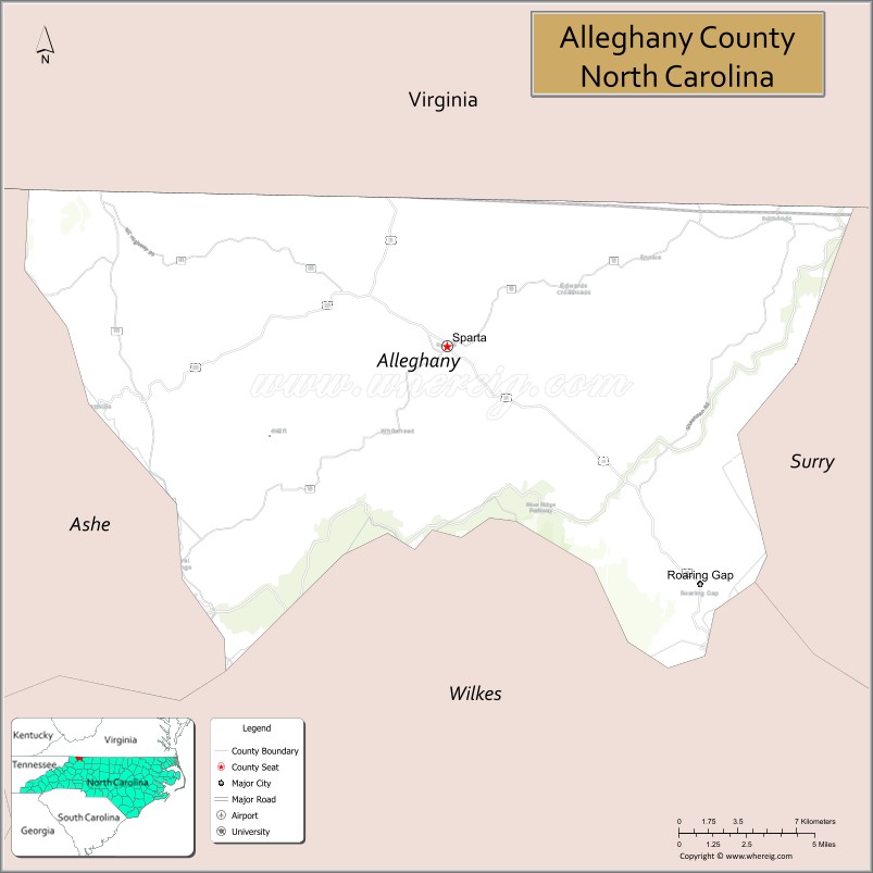
About Alleghany County Map, North Carolina: The map showing the county boundary, county seat, major cities, highways, water bodies and neighbouring counties.
Related North Carolina Links
About Alleghany County, North Carolina
Alleghany County is a county located in the U.S. state of North Carolina. It's county seat is Sparta. As per 2020 census, the population of Alleghany County is 11049 people and population density is square miles. According to the United States Census Bureau, the county has a total area of 236 sq mi (611 km2). Alleghany County was established on 1859.
Alleghany County Facts
| Continent | North America |
| Country | United States |
| State | North Carolina |
| County Seat | Sparta |
| Largest City/Town | Sparta |
| Established | 1859 |
| Total Area | 237 sq mi (614 sq km) |
| Land Area | 235 sq mi (609 sq km) |
| Water Area | 2 sq mi (5 sq km) |
| Population | 10,888 (Census 2020) |
| Population Density | 46 people per sq mi |
| Time Zone | Eastern Time Zone (ET) |
| Major Highways | US-21, US-221, NC-18, NC-93 |
| Major Rivers | New River, Little River |
| Neighboring Counties | Ashe County, Surry County, Wilkes County, Grayson County (VA) |
| Famous For | Blue Ridge Mountains scenery, New River, outdoor recreation |
| Top Attractions | New River State Park, Blue Ridge Parkway, Stone Mountain State Park, Sparta Historic District |
| Official Website | Official Website |
About Alleghany County, North Carolina
Alleghany County is located in the northwestern part of North Carolina, in the state of the United States, and was established in 1859. The county seat is Sparta, which is also the largest town. The county lies within the Blue Ridge Mountains and is known for its scenic landscapes, rolling hills, and access to the historic New River.
Cities and Towns in Alleghany County, North Carolina
| City/Town | Population (Census 2020) | Latitude & Longitude |
|---|---|---|
| Sparta (county seat) | 1,783 | 36.5040°N, 81.1195°W |
| Piney Creek (CDP) | 1,306 | 36.5530°N, 81.2987°W |
| Roaring Gap (CDP) | 107 | 36.3979°N, 80.9765°W |
| Laurel Springs (CDP) | 149 | 36.3957°N, 81.2687°W |
Golf Courses in Alleghany County, North Carolina
| Golf Course | Location | Latitude & Longitude |
|---|---|---|
| Olde Beau Golf & Country Club | Roaring Gap | 36.3990°N, 80.9752°W |
| High Meadows Country Club | Roaring Gap | 36.4025°N, 80.9731°W |
Roads and Highways in Alleghany County, North Carolina
The county is connected by several key highways that link it to surrounding mountain communities.
- US-21 – runs north–south connecting Sparta to Virginia and Wilkes County
- US-221 – passes through the county linking Jefferson and Independence, VA
- NC-18 – connects Sparta to Wilkes County and Morganton
- NC-93 – provides local access toward Piney Creek and the Virginia border
Neighboring Counties of Alleghany County
- Ashe County (northwest)
- Grayson County, Virginia (north)
- Surry County (east)
- Wilkes County (south)
Top Attractions in Alleghany County, North Carolina
Visitors come here mainly for nature, scenic drives, and quiet mountain towns.
- New River State Park – one of the oldest rivers in the world, perfect for kayaking and camping
- Blue Ridge Parkway – scenic mountain drive with overlooks and hiking trails
- Stone Mountain State Park – granite dome hikes and waterfalls nearby
- Sparta Historic District – small-town charm with shops and local history
- Roaring Gap – peaceful mountain retreat with scenic views
- New River Trail access – great for fishing and paddling
Distance from Alleghany County to Nearby Cities
- Sparta to Winston-Salem – 80 mi (129 km)
- Sparta to Boone – 50 mi (80 km)
- Sparta to Charlotte – 120 mi (193 km)
- Sparta to Roanoke, VA – 95 mi (153 km)
- Sparta to Greensboro – 95 mi (153 km)
FAQs about Alleghany County
Alleghany County is located in northwestern North Carolina along the Virginia border in the Blue Ridge Mountains.
The population of Alleghany County is 10,888 according to the 2020 Census.
The county is known for its mountain scenery, the New River, outdoor recreation, and peaceful rural atmosphere.
Major highways include US-21, US-221, NC-18, and NC-93.
Yes, there are golf courses including Olde Beau Golf & Country Club and High Meadows Country Club.
- Alamance County Map
- Alexander County Map
- Alleghany County Map
- Anson County Map
- Ashe County Map
- Avery County Map
- Beaufort County Map
- Bertie County Map
- Bladen County Map
- Brunswick County Map
- Buncombe County Map
- Burke County Map
- Cabarrus County Map
- Caldwell County Map
- Camden County Map
- Carteret County Map
- Caswell County Map
- Catawba County Map
- Chatham County Map
- Cherokee County Map
- Chowan County Map
- Clay County Map
- Cleveland County Map
- Columbus County Map
- Craven County Map
- Cumberland County Map
- Currituck County Map
- Dare County Map
- Davidson County Map
- Davie County Map
- Duplin County Map
- Durham County Map
- Edgecombe County Map
- Forsyth County Map
- Franklin County Map
- Gaston County Map
- Gates County Map
- Graham County Map
- Granville County Map
- Greene County Map
- Guilford County Map
- Halifax County Map
- Harnett County Map
- Haywood County Map
- Henderson County Map
- Hertford County Map
- Hoke County Map
- Hyde County Map
- Iredell County Map
- Jackson County Map
- Johnston County Map
- Jones County Map
- Lee County Map
- Lenoir County Map
- Lincoln County Map
- McDowell County Map
- Macon County Map
- Madison County Map
- Martin County Map
- Mecklenburg County Map
- Mitchell County Map
- Montgomery County Map
- Moore County Map
- Nash County Map
- New Hanover County Map
- Northampton County Map
- Onslow County Map
- Orange County Map
- Pamlico County Map
- Pasquotank County Map
- Pender County Map
- Perquimans County Map
- Person County Map
- Pitt County Map
- Polk County Map
- Randolph County Map
- Richmond County Map
- Robeson County Map
- Rockingham County Map
- Rowan County Map
- Rutherford County Map
- Sampson County Map
- Scotland County Map
- Stanly County Map
- Stokes County Map
- Surry County Map
- Swain County Map
- Transylvania County Map
- Tyrrell County Map
- Union County Map
- Vance County Map
- Wake County Map
- Warren County Map
- Washington County Map
- Watauga County Map
- Wayne County Map
- Wilkes County Map
- Wilson County Map
- Yadkin County Map
- Yancey County Map
- Alabama Counties
- Alaska boroughs
- Arizona Counties
- Arkansas Counties
- California County Map
- Colorado Counties
- Connecticut Counties
- Delaware Counties
- Florida County Map
- Georgia County Map
- Hawaii Counties
- Idaho Counties
- Illinois Counties
- Indiana Counties
- Iowa Counties
- Kansas Counties
- Kentucky Counties
- Louisiana Counties
- Maine Counties
- Maryland Counties
- Massachusetts Counties
- Michigan County Map
- Minnesota Counties
- Mississippi Counties
- Missouri Counties
- Montana Counties
- Nebraska Counties
- Nevada Counties
- New York Counties
- New Hampshire Counties
- New Jersey Counties
- New Mexico Counties
- North Carolina Counties
- North Dakota Counties
- Ohio County Map
- Oklahoma Counties
- Oregon Counties
- Pennsylvania Counties
- Rhode Island Counties
- South Carolina Counties
- South Dakota Counties
- Map of Tennessee
- Texas County Map
- Utah Counties
- Vermont Counties
- Virginia Counties
- Washington Counties
- West Virginia Counties
- Wisconsin Counties
- Wyoming Counties