Map of Lenoir County - Lenoir County is a county located in the U.S. state of North Carolina. Lenoir County Map showing cities, highways, important places and water bodies. Get Where is Lenoir County located in the map, major cities in Lenoir county, population, areas, and places of interest.
Map of Lenoir County, North Carolina
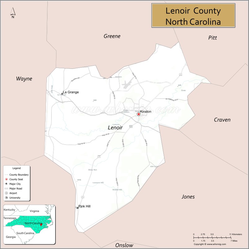
About Lenoir County Map, North Carolina: The map showing the county boundary, county seat, major cities, highways, water bodies and neighbouring counties.
Related North Carolina Links
About Lenoir County, North Carolina
Lenoir County is a county located in the U.S. state of North Carolina. It's county seat is Kinston. As per 2020 census, the population of Lenoir County is 54706 people and population density is square miles. According to the United States Census Bureau, the county has a total area of 402 sq mi (1,041 km2). Lenoir County was established on 1791.
Lenoir County Facts
| Continent | North America |
| Country | United States |
| State | North Carolina |
| County Seat | Kinston |
| Largest City/Town | Kinston |
| Established | 1791 |
| Total Area | 403 sq mi (1,044 sq km) |
| Land Area | 401 sq mi (1,039 sq km) |
| Water Area | 2 sq mi (5 sq km) |
| Population | 54,833 (Census 2020) |
| Population Density | 137 people per sq mi |
| Time Zone | Eastern Time Zone (ET) |
| Major Highways | US-70, US-258, NC-11, NC-55 |
| Major Rivers | Neuse River |
| Neighboring Counties | Pitt County, Greene County, Jones County, Craven County, Wayne County, Duplin County |
| Famous For | Barbecue, Kinston history, agriculture |
| Top Attractions | CSS Neuse Civil War Interpretive Center, Mother Earth Brewing, Neuseway Nature Park, Harmony Hall |
| Official Website | Official Website |
About Lenoir County, North Carolina
Lenoir County is located in the eastern part of North Carolina, in the state of the United States, and was established in 1791. The county seat is Kinston, which is also the largest city. The county lies within the coastal plain region along the Neuse River and is known for its agricultural heritage, historic sites, and distinctive barbecue culture.
Cities and Towns in Lenoir County, North Carolina
| City/Town | Population (Census 2020) | Latitude & Longitude |
|---|---|---|
| Kinston (county seat) | 19,323 | 35.2627°N, 77.5816°W |
| La Grange | 2,708 | 35.3057°N, 77.7939°W |
| Pink Hill | 500 | 35.0500°N, 77.7500°W |
| Deep Run (CDP) | 300 | 35.1300°N, 77.7100°W |
| Falling Creek (CDP) | 400 | 35.3000°N, 77.6500°W |
Golf Courses in Lenoir County, North Carolina
| Golf Course | Location | Latitude & Longitude |
|---|---|---|
| Kinston Country Club | Kinston | 35.2700°N, 77.5800°W |
| Falling Creek Country Club | La Grange area | 35.3000°N, 77.7000°W |
Roads and Highways in Lenoir County, North Carolina
Lenoir County is served by major highways connecting eastern North Carolina communities.
- US-70 – major east–west route connecting Kinston to Raleigh and the coast
- US-258 – runs north–south linking the county to Tarboro and Jacksonville
- NC-11 – connects the county to Greenville and Duplin County
- NC-55 – provides additional regional access
Neighboring Counties of Lenoir County
- Pitt County (north)
- Greene County (northwest)
- Wayne County (west)
- Duplin County (southwest)
- Jones County (south)
- Craven County (southeast)
Top Attractions in Lenoir County, North Carolina
The county offers history, culture, and outdoor recreation.
- CSS Neuse Civil War Interpretive Center – exhibits on a Civil War ironclad ship
- Mother Earth Brewing – popular local brewery
- Neuseway Nature Park – park with trails, zoo, and recreation areas
- Harmony Hall – historic plantation site
- Downtown Kinston – restaurants, shops, and cultural venues
- Neuse River – fishing, kayaking, and scenic views
Distance from Lenoir County to Nearby Cities
- Kinston to Greenville – 25 mi (40 km)
- Kinston to Goldsboro – 25 mi (40 km)
- Kinston to New Bern – 35 mi (56 km)
- Kinston to Raleigh – 80 mi (129 km)
- Kinston to Wilmington – 100 mi (161 km)
FAQs about Lenoir County
Lenoir County is located in eastern North Carolina along the Neuse River.
The population of Lenoir County is 54,833 according to the 2020 Census.
Lenoir County is known for its barbecue, agriculture, and historic sites in Kinston.
Major highways include US-70, US-258, NC-11, and NC-55.
Yes, Lenoir County has golf courses including Kinston Country Club and Falling Creek Country Club.
- Alamance County Map
- Alexander County Map
- Alleghany County Map
- Anson County Map
- Ashe County Map
- Avery County Map
- Beaufort County Map
- Bertie County Map
- Bladen County Map
- Brunswick County Map
- Buncombe County Map
- Burke County Map
- Cabarrus County Map
- Caldwell County Map
- Camden County Map
- Carteret County Map
- Caswell County Map
- Catawba County Map
- Chatham County Map
- Cherokee County Map
- Chowan County Map
- Clay County Map
- Cleveland County Map
- Columbus County Map
- Craven County Map
- Cumberland County Map
- Currituck County Map
- Dare County Map
- Davidson County Map
- Davie County Map
- Duplin County Map
- Durham County Map
- Edgecombe County Map
- Forsyth County Map
- Franklin County Map
- Gaston County Map
- Gates County Map
- Graham County Map
- Granville County Map
- Greene County Map
- Guilford County Map
- Halifax County Map
- Harnett County Map
- Haywood County Map
- Henderson County Map
- Hertford County Map
- Hoke County Map
- Hyde County Map
- Iredell County Map
- Jackson County Map
- Johnston County Map
- Jones County Map
- Lee County Map
- Lenoir County Map
- Lincoln County Map
- McDowell County Map
- Macon County Map
- Madison County Map
- Martin County Map
- Mecklenburg County Map
- Mitchell County Map
- Montgomery County Map
- Moore County Map
- Nash County Map
- New Hanover County Map
- Northampton County Map
- Onslow County Map
- Orange County Map
- Pamlico County Map
- Pasquotank County Map
- Pender County Map
- Perquimans County Map
- Person County Map
- Pitt County Map
- Polk County Map
- Randolph County Map
- Richmond County Map
- Robeson County Map
- Rockingham County Map
- Rowan County Map
- Rutherford County Map
- Sampson County Map
- Scotland County Map
- Stanly County Map
- Stokes County Map
- Surry County Map
- Swain County Map
- Transylvania County Map
- Tyrrell County Map
- Union County Map
- Vance County Map
- Wake County Map
- Warren County Map
- Washington County Map
- Watauga County Map
- Wayne County Map
- Wilkes County Map
- Wilson County Map
- Yadkin County Map
- Yancey County Map
- Alabama Counties
- Alaska boroughs
- Arizona Counties
- Arkansas Counties
- California County Map
- Colorado Counties
- Connecticut Counties
- Delaware Counties
- Florida County Map
- Georgia County Map
- Hawaii Counties
- Idaho Counties
- Illinois Counties
- Indiana Counties
- Iowa Counties
- Kansas Counties
- Kentucky Counties
- Louisiana Counties
- Maine Counties
- Maryland Counties
- Massachusetts Counties
- Michigan County Map
- Minnesota Counties
- Mississippi Counties
- Missouri Counties
- Montana Counties
- Nebraska Counties
- Nevada Counties
- New York Counties
- New Hampshire Counties
- New Jersey Counties
- New Mexico Counties
- North Carolina Counties
- North Dakota Counties
- Ohio County Map
- Oklahoma Counties
- Oregon Counties
- Pennsylvania Counties
- Rhode Island Counties
- South Carolina Counties
- South Dakota Counties
- Map of Tennessee
- Texas County Map
- Utah Counties
- Vermont Counties
- Virginia Counties
- Washington Counties
- West Virginia Counties
- Wisconsin Counties
- Wyoming Counties