Map of Union County - Union County is a county located in the U.S. state of North Carolina. Union County Map showing cities, highways, important places and water bodies. Get Where is Union County located in the map, major cities in Union county, population, areas, and places of interest.
Map of Union County, North Carolina
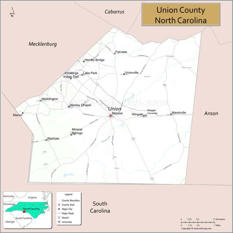
About Union County Map, North Carolina: The map showing the county boundary, county seat, major cities, highways, water bodies and neighbouring counties.
Related North Carolina Links
About Union County, North Carolina
Union County is a county located in the U.S. state of North Carolina. It's county seat is Monroe. As per 2020 census, the population of Union County is 243648 people and population density is square miles. According to the United States Census Bureau, the county has a total area of 640 sq mi (1,658 km2). Union County was established on 1842.
Union County Facts
| Continent | North America |
| Country | United States |
| State | North Carolina |
| County Seat | Monroe |
| Largest City/Town | Monroe |
| Established | 1842 |
| Total Area | 640 sq mi (1,658 sq km) |
| Land Area | 632 sq mi (1,637 sq km) |
| Water Area | 8 sq mi (21 sq km) |
| Population | 238,267 (Census 2020) |
| Population Density | 377 people per sq mi |
| Time Zone | Eastern Time Zone (ET) |
| Major Highways | US-74, US-601, NC-16, NC-200 |
| Major Rivers | Catawba River, Rocky River |
| Neighboring Counties | Mecklenburg County, Cabarrus County, Stanly County, Anson County, Lancaster County (SC), Chesterfield County (SC) |
| Famous For | Suburban growth, proximity to Charlotte, agriculture |
| Top Attractions | Cane Creek Park, Treehouse Vineyards, Monroe Historic District, Wingate University |
| Official Website | Official Website |
About Union County, North Carolina
Union County is located in the south-central part of North Carolina, in the state of the United States, and was established in 1842. The county seat is Monroe, which is also the largest city. The county lies southeast of Charlotte in the Piedmont region and is known for its rapid suburban growth, strong local economy, and mix of urban and rural communities.
Cities and Towns in Union County, North Carolina
| City/Town | Population (Census 2020) | Latitude & Longitude |
|---|---|---|
| Monroe (county seat) | 34,551 | 34.9854°N, 80.5495°W |
| Indian Trail | 39,973 | 35.0800°N, 80.6700°W |
| Weddington | 12,000+ | 35.0300°N, 80.7400°W |
| Waxhaw | 20,534 | 34.9250°N, 80.7400°W |
| Marshville | 2,700 | 34.9800°N, 80.3700°W |
| Wingate | 3,400 | 34.9800°N, 80.4500°W |
| Mineral Springs | 3,000 | 34.9400°N, 80.6400°W |
| Fairview | 3,500 | 35.0200°N, 80.5400°W |
Golf Courses in Union County, North Carolina
| Golf Course | Location | Latitude & Longitude |
|---|---|---|
| Rolling Hills Country Club | Monroe | 34.9900°N, 80.5500°W |
| Stonebridge Golf Club | Monroe | 34.9800°N, 80.6000°W |
Roads and Highways in Union County, North Carolina
Union County is connected by major highways serving the Charlotte metropolitan area.
- US-74 – major east–west route connecting the county to Charlotte
- US-601 – runs north–south through Monroe
- NC-16 – connects the county to Mecklenburg County
- NC-200 – provides regional access
Neighboring Counties of Union County
- Mecklenburg County (northwest)
- Cabarrus County (north)
- Stanly County (northeast)
- Anson County (east)
- Chesterfield County, South Carolina (south)
- Lancaster County, South Carolina (southwest)
Top Attractions in Union County, North Carolina
The county offers parks, wineries, and growing suburban attractions.
- Cane Creek Park – outdoor recreation, lake, and trails
- Treehouse Vineyards – unique vineyard with treehouse stays
- Monroe Historic District – shops, dining, and historic buildings
- Wingate University – educational and cultural center
- Downtown Waxhaw – historic charm and local shops
- Local parks and greenways – outdoor activities and recreation
Distance from Union County to Nearby Cities
- Monroe to Charlotte – 25 mi (40 km)
- Monroe to Concord – 30 mi (48 km)
- Monroe to Columbia, SC – 80 mi (129 km)
- Monroe to Raleigh – 130 mi (209 km)
- Monroe to Greenville, SC – 100 mi (161 km)
FAQs about Union County
Union County is located in south-central North Carolina southeast of Charlotte.
The population of Union County is 238,267 according to the 2020 Census.
Union County is known for its suburban growth, proximity to Charlotte, and agricultural heritage.
Major highways include US-74, US-601, NC-16, and NC-200.
Yes, Union County has golf courses including Rolling Hills Country Club and Stonebridge Golf Club.
- Alamance County Map
- Alexander County Map
- Alleghany County Map
- Anson County Map
- Ashe County Map
- Avery County Map
- Beaufort County Map
- Bertie County Map
- Bladen County Map
- Brunswick County Map
- Buncombe County Map
- Burke County Map
- Cabarrus County Map
- Caldwell County Map
- Camden County Map
- Carteret County Map
- Caswell County Map
- Catawba County Map
- Chatham County Map
- Cherokee County Map
- Chowan County Map
- Clay County Map
- Cleveland County Map
- Columbus County Map
- Craven County Map
- Cumberland County Map
- Currituck County Map
- Dare County Map
- Davidson County Map
- Davie County Map
- Duplin County Map
- Durham County Map
- Edgecombe County Map
- Forsyth County Map
- Franklin County Map
- Gaston County Map
- Gates County Map
- Graham County Map
- Granville County Map
- Greene County Map
- Guilford County Map
- Halifax County Map
- Harnett County Map
- Haywood County Map
- Henderson County Map
- Hertford County Map
- Hoke County Map
- Hyde County Map
- Iredell County Map
- Jackson County Map
- Johnston County Map
- Jones County Map
- Lee County Map
- Lenoir County Map
- Lincoln County Map
- McDowell County Map
- Macon County Map
- Madison County Map
- Martin County Map
- Mecklenburg County Map
- Mitchell County Map
- Montgomery County Map
- Moore County Map
- Nash County Map
- New Hanover County Map
- Northampton County Map
- Onslow County Map
- Orange County Map
- Pamlico County Map
- Pasquotank County Map
- Pender County Map
- Perquimans County Map
- Person County Map
- Pitt County Map
- Polk County Map
- Randolph County Map
- Richmond County Map
- Robeson County Map
- Rockingham County Map
- Rowan County Map
- Rutherford County Map
- Sampson County Map
- Scotland County Map
- Stanly County Map
- Stokes County Map
- Surry County Map
- Swain County Map
- Transylvania County Map
- Tyrrell County Map
- Union County Map
- Vance County Map
- Wake County Map
- Warren County Map
- Washington County Map
- Watauga County Map
- Wayne County Map
- Wilkes County Map
- Wilson County Map
- Yadkin County Map
- Yancey County Map
- Alabama Counties
- Alaska boroughs
- Arizona Counties
- Arkansas Counties
- California County Map
- Colorado Counties
- Connecticut Counties
- Delaware Counties
- Florida County Map
- Georgia County Map
- Hawaii Counties
- Idaho Counties
- Illinois Counties
- Indiana Counties
- Iowa Counties
- Kansas Counties
- Kentucky Counties
- Louisiana Counties
- Maine Counties
- Maryland Counties
- Massachusetts Counties
- Michigan County Map
- Minnesota Counties
- Mississippi Counties
- Missouri Counties
- Montana Counties
- Nebraska Counties
- Nevada Counties
- New York Counties
- New Hampshire Counties
- New Jersey Counties
- New Mexico Counties
- North Carolina Counties
- North Dakota Counties
- Ohio County Map
- Oklahoma Counties
- Oregon Counties
- Pennsylvania Counties
- Rhode Island Counties
- South Carolina Counties
- South Dakota Counties
- Map of Tennessee
- Texas County Map
- Utah Counties
- Vermont Counties
- Virginia Counties
- Washington Counties
- West Virginia Counties
- Wisconsin Counties
- Wyoming Counties