Map of Rowan County - Rowan County is a county located in the U.S. state of North Carolina. Rowan County Map showing cities, highways, important places and water bodies. Get Where is Rowan County located in the map, major cities in Rowan county, population, areas, and places of interest.
Map of Rowan County, North Carolina
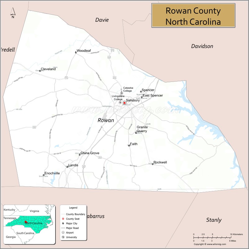
About Rowan County Map, North Carolina: The map showing the county boundary, county seat, major cities, highways, water bodies and neighbouring counties.
Most Viewed NC Maps & Info
About Rowan County, North Carolina
Rowan County is a county located in the U.S. state of North Carolina. It's county seat is Salisbury. As per 2020 census, the population of Rowan County is 148150 people and population density is square miles. According to the United States Census Bureau, the county has a total area of 524 sq mi (1,357 km2). Rowan County was established on 1753.
Facts about Rowan County, North Carolina
| Country | United States |
| State | North Carolina |
| Region | Piedmont / Central North Carolina |
| County Seat | Salisbury |
| Named After | Matthew Rowan, Acting Governor of North Carolina |
| Established | 1753 (from part of Anson County) |
| Coordinates | ~35.67° N, 80.47° W |
| Total Area | ~524 sq mi |
| Land Area | ~520 sq mi |
| Water Area | ~4 sq mi |
| Population (2020) | ~146,875 |
| Estimated Population (2025) | ~150,000 |
| Population Rank (NC) | ~25th largest county |
| Largest City | Salisbury |
| Main Towns & Communities | Salisbury, China Grove, Spencer, Kannapolis (part), Landis, Rockwell, East Spencer, Faith, Granite Quarry, Mount Ulla |
| Main Industries | Manufacturing, Agriculture, Services, Education, Healthcare |
| Major Geographic Features | Yadkin River, High Rock Lake, Piedmont terrain |
| Time Zone | Eastern Time (UTC−05:00 / −04:00 DST) |
| Known For | Historic Salisbury, North Carolina Transportation Museum, Old Stone House, Civil War history & cultural heritage |
| Website | https://www.rowancountync.gov |
Top Attractions in Rowan County, North Carolina
- Historic Downtown Salisbury – Shops, dining, and historic buildings.
- North Carolina Transportation Museum – Trains and transportation exhibits.
- Dan Nicholas Park – Zoo, amusement rides, and trails.
- Latta Plantation – Historic home and gardens.
- Randy Parton Theater – Live performances and concerts.
- F&M Park – Recreation and walking trails.
- Rowan Museum – Local history exhibits.
- Old Stone House – Historic architecture and museum.
- Riegelwood Park – Outdoor activities and picnics.
- Davie-Loudon Park – Community recreation space.
Cities & Towns in Rowan County, North Carolina
China Grove, Landis, Rockwell, Salisbury, Spencer, Faith, Gold Hill, Granite Quarry, Mount Ulla, Cleveland
- Alamance County Map
- Alexander County Map
- Alleghany County Map
- Anson County Map
- Ashe County Map
- Avery County Map
- Beaufort County Map
- Bertie County Map
- Bladen County Map
- Brunswick County Map
- Buncombe County Map
- Burke County Map
- Cabarrus County Map
- Caldwell County Map
- Camden County Map
- Carteret County Map
- Caswell County Map
- Catawba County Map
- Chatham County Map
- Cherokee County Map
- Chowan County Map
- Clay County Map
- Cleveland County Map
- Columbus County Map
- Craven County Map
- Cumberland County Map
- Currituck County Map
- Dare County Map
- Davidson County Map
- Davie County Map
- Duplin County Map
- Durham County Map
- Edgecombe County Map
- Forsyth County Map
- Franklin County Map
- Gaston County Map
- Gates County Map
- Graham County Map
- Granville County Map
- Greene County Map
- Guilford County Map
- Halifax County Map
- Harnett County Map
- Haywood County Map
- Henderson County Map
- Hertford County Map
- Hoke County Map
- Hyde County Map
- Iredell County Map
- Jackson County Map
- Johnston County Map
- Jones County Map
- Lee County Map
- Lenoir County Map
- Lincoln County Map
- McDowell County Map
- Macon County Map
- Madison County Map
- Martin County Map
- Mecklenburg County Map
- Mitchell County Map
- Montgomery County Map
- Moore County Map
- Nash County Map
- New Hanover County Map
- Northampton County Map
- Onslow County Map
- Orange County Map
- Pamlico County Map
- Pasquotank County Map
- Pender County Map
- Perquimans County Map
- Person County Map
- Pitt County Map
- Polk County Map
- Randolph County Map
- Richmond County Map
- Robeson County Map
- Rockingham County Map
- Rowan County Map
- Rutherford County Map
- Sampson County Map
- Scotland County Map
- Stanly County Map
- Stokes County Map
- Surry County Map
- Swain County Map
- Transylvania County Map
- Tyrrell County Map
- Union County Map
- Vance County Map
- Wake County Map
- Warren County Map
- Washington County Map
- Watauga County Map
- Wayne County Map
- Wilkes County Map
- Wilson County Map
- Yadkin County Map
- Yancey County Map
- Alabama Counties
- Alaska boroughs
- Arizona Counties
- Arkansas Counties
- California County Map
- Colorado Counties
- Connecticut Counties
- Delaware Counties
- Florida County Map
- Georgia County Map
- Hawaii Counties
- Idaho Counties
- Illinois Counties
- Indiana Counties
- Iowa Counties
- Kansas Counties
- Kentucky Counties
- Louisiana Counties
- Maine Counties
- Maryland Counties
- Massachusetts Counties
- Michigan County Map
- Minnesota Counties
- Mississippi Counties
- Missouri Counties
- Montana Counties
- Nebraska Counties
- New Hampshire Counties
- New Jersey Counties
- New Mexico Counties
- North Carolina Counties
- North Dakota Counties
- Oklahoma Counties
- Oregon Counties
- Pennsylvania Counties
- Rhode Island Counties
- South Carolina Counties
- South Dakota Counties
- Map of Tennessee
- Texas County Map
- Utah Counties
- Vermont Counties
- Virginia Counties
- Washington Counties
- West Virginia Counties
- Wisconsin Counties
- Wyoming Counties
- Nevada Counties
- New York Counties
- Ohio County Map