
Where is Elizabeth City Located? - Elizabeth City is a city located in the Pasquotank County of North Carolina, United States. Elizabeth City lies between 40.7684342 Degrees North latitudes and 74.1454214 Degrees West longitudes.
Location Map of Elizabeth City, North Carolina
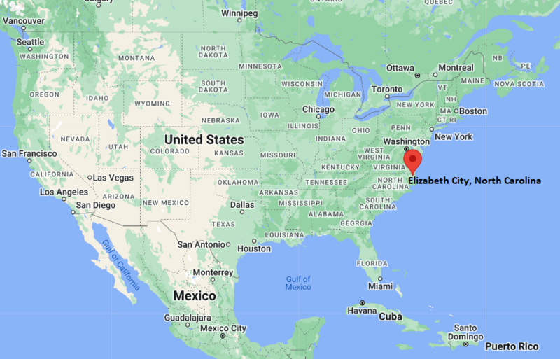
Elizabeth City Map, North Carolina, USA
Where is Elizabeth City?: The Google Map showing the location of Elizabeth City in the U.S. state of North Carolina.
Where is Elizabeth City Located?
Elizabeth City is a city located in the Pasquotank County of North Carolina, United States. Elizabeth City lies between 40.7684342 Degrees North latitudes and 74.1454214 Degrees West longitudes. According to 2020 U.S.census, the population of Elizabeth City city is 18631 people and the city has a total area of 11.69 sq mi. The city has numerous parks and recreational facilities.
Most Viewed US Maps
| USA Sttae Map | USA Region Map | USA Road Map |
| USA County Map | Where is USA in World Map? | US ZIP Code Map |
| USA Time Zones Map | US State and Capitals Map | USA Physical Map |
Find 4,400+ U.S. Cities by State - Explore Their Locations and Get Detailed Information
Elizabeth City, North Carolina Quick Facts
| Property | Details |
|---|---|
| City | Elizabeth City |
| County | Pasquotank County |
| State | North Carolina |
| State Capital | Raleigh |
| US Region | South |
| Latitude | 36.2946°N |
| Longitude | 76.2510°W |
| Elevation | 12 ft (4 m) |
| Land Area | 11.77 sq mi |
| Water Area | 0.61 sq mi |
| Total Area | 12.38 sq mi |
| Population (2020 Census) | 18,683 |
| Population Density | Approximately 1,588 per sq mi |
| ZIP Codes | 27906, 27907, 27909 |
| Area Code | 252 |
| Time Zone Standard | Eastern Standard Time (EST), UTC−5 |
| Time Zone Daylight | Eastern Daylight Time (EDT), UTC−4 |
| Currency | US Dollar (USD) |
| FIPS Code | 37-20580 |
| Congressional District | North Carolina's 1st Congressional District |
Nearby Cities to Elizabeth City, North Carolina
- Winfall, North Carolina - South - 5 mi
- Hertford, North Carolina - Southwest - 12 mi
- Camden, North Carolina - East - 10 mi
- South Mills, North Carolina - Northeast - 17 mi
- Edenton, North Carolina - Southwest - 30 mi
- Moyock, North Carolina - North - 34 mi
- Virginia Beach, Virginia - North - 48 mi
- Chesapeake, Virginia - North - 44 mi
- Kill Devil Hills, North Carolina - Southeast - 57 mi
- Norfolk, Virginia - North - 50 mi
Elizabeth City, North Carolina Climate and Weather Overview
| Month | Avg High (°F) | Avg Low (°F) | Avg Rainfall (in) |
|---|---|---|---|
| January | 50 | 32 | 3.50 |
| April | 71 | 48 | 3.40 |
| July | 89 | 72 | 5.80 |
| October | 73 | 52 | 3.70 |
| Annual | 72 | 52 | 49.20 |
| Climate Attribute | Details |
|---|---|
| Climate Classification (Köppen) | Humid Subtropical (Cfa) |
| Annual Rainfall | Approximately 49 inches |
| Annual Sunshine Days | About 214 days |
| Hurricane/Tornado Risk | Moderate hurricane risk; low tornado risk |
| Snowfall | Approximately 3 inches annually |
Driving Distances from Elizabeth City, North Carolina
| City | State | Distance (mi) | Approx. Drive Time |
|---|---|---|---|
| Winfall | North Carolina | 5 | 8 min |
| Camden | North Carolina | 10 | 15 min |
| Hertford | North Carolina | 12 | 18 min |
| South Mills | North Carolina | 17 | 22 min |
| Edenton | North Carolina | 30 | 40 min |
| Moyock | North Carolina | 34 | 40 min |
| Chesapeake | Virginia | 44 | 55 min |
| Virginia Beach | Virginia | 48 | 1 hr |
| Norfolk | Virginia | 50 | 1 hr 5 min |
| Raleigh | North Carolina | 170 | 2 hr 45 min |
Transportation and Connectivity in Elizabeth City, North Carolina
| Transportation | Details |
|---|---|
| Airport Name | Elizabeth City Regional Airport |
| IATA Code | ECG |
| Port | Port of Elizabeth City |
| Major Highways | U.S. Highway 17, U.S. Highway 158, North Carolina Highway 344, North Carolina Highway 37 |
| Train/Amtrak Service | No passenger rail service; nearest Amtrak station in Norfolk, Virginia |
| Local Bus/Transit Service | Inter-County Public Transportation Authority (ICPTA) |
- U.S. Highway 17 - Primary north-south route connecting Elizabeth City with Chesapeake, Virginia, and New Bern.
- U.S. Highway 158 - Major east-west highway providing access to the Outer Banks and central North Carolina.
- North Carolina Highways 344 and 37 connect the city with nearby communities throughout northeastern North Carolina.
- Elizabeth City Regional Airport supports general aviation, while the nearby Port of Elizabeth City serves commercial and recreational maritime activities.
Places to Visit in Elizabeth City, North Carolina
| Landmark Name | Type |
|---|---|
| Museum of the Albemarle | History Museum |
| Waterfront Park | City Park |
| Arts of the Albemarle | Arts Center |
| Port Discover Science Center | Children's Museum |
| Dismal Swamp State Park | State Park |
| Elizabeth City Historic District | Historic District |
| Charles Creek Park | Waterfront Park |
| Coast Guard Base Elizabeth City | Military Installation |
| Albemarle Plantation Marina | Marina |
| Peninsula Park | Community Park |
Colleges and Universities in Elizabeth City, North Carolina
| Institution Name | Type | Level | Notable For |
|---|---|---|---|
| Elizabeth City State University | Public | University | Historically Black university and aviation programs |
| College of The Albemarle | Public | Community College | Academic transfer and workforce education |
| Mid-Atlantic Christian University | Private | University | Christian liberal arts education |
| East Carolina University | Public | University | Research and graduate programs |
| Old Dominion University | Public | University | Engineering and business education |
| Tidewater Community College | Public | Community College | Career and technical education |
| Regent University | Private | University | Graduate and professional studies |
| Elizabeth City-Pasquotank Public Schools | Public | K–12 District | Public education |
Waterbodies in Elizabeth City, North Carolina
Pasquotank River, Albemarle Sound, Charles Creek, Knobbs Creek, Dismal Swamp Canal, Little River, North River, Camden Creek
Golf Courses in Elizabeth City, North Carolina
The Pines at Elizabeth City, Albemarle Plantation Golf Club, The Carolina Club, Kilmarlic Golf Club, Duck Woods Country Club, Holly Ridge Golf Course, Currituck Club, Nags Head Golf Links
Elizabeth City, North Carolina — Key Historical Facts
- Elizabeth City was established in 1793 and became the county seat of Pasquotank County, developing as an important port along the Pasquotank River.
- Its waterfront location made the city a major center for shipping, lumber, seafood, and agricultural trade throughout the 19th century.
- The city played an important role during the Civil War and later expanded as a regional commercial and transportation hub in northeastern North Carolina.
- The establishment of the U.S. Coast Guard Air Station in the 1940s strengthened Elizabeth City's role in aviation, search and rescue, and military operations.
- Elizabeth City State University, founded in 1891, has become a significant educational institution serving the region.
- Today, Elizabeth City is known as the "Harbor of Hospitality" for its welcoming downtown waterfront, maritime heritage, educational institutions, and tourism.
References
North Carolina Maps and Info
- Where is Albemarle
- Where is Apex
- Where is Asheboro
- Where is Asheville
- Where is Belmont
- Where is Boone
- Where is Burlington
- Where is Carrboro
- Where is Cary
- Where is Chapel Hill
- Where is Clayton
- Where is Clemmons
- Where is Concord
- Where is Cornelius
- Where is Davidson
- Where is Eden
- Where is Elizabeth City
- Where is Fuquay-Varina
- Where is Garner
- Where is Gastonia
- Where is Goldsboro
- Where is Graham
- Where is Greenville
- Where is Harrisburg
- Where is Havelock
- Where is Hendersonville
- Where is Hickory
- Where is High Point
- Where is Holly Springs
- Where is Hope Mills
- Where is Huntersville
- Where is Indian Trail
- Where is Kannapolis
- Where is Kernersville
- Where is Kinston
- Where is Knightdale
- Where is Laurinburg
- Where is Leland
- Where is Lenoir
- Where is Lumberton
- Where is Matthews
- Where is Mebane
- Where is Mint Hill
- Where is Monroe
- Where is Mooresville
- Where is Morganton
- Where is Morrisville
- Where is Mount Holly
- Where is Murraysville
- Where is New Bern
- Where is Pinehurst
- Where is Piney Green
- Where is Reidsville
- Where is Roanoke Rapids
- Where is Rocky Mount
- Where is Salisbury
- Where is Sanford
- Where is Shelby
- Where is Southern Pines
- Where is Stallings
- Where is Statesville
- Where is Thomasville
- Where is Wake Forest
- Where is Waxhaw
- Where is Wilmington
- Where is Wilson
- Where is Winston-Salem