
Where is Garner Located? - Garner is a city located in the Wake County of North Carolina, United States. Garner lies between 34.8547756 Degrees North latitudes and 106.7053035 Degrees West longitudes.
Location Map of Garner, North Carolina
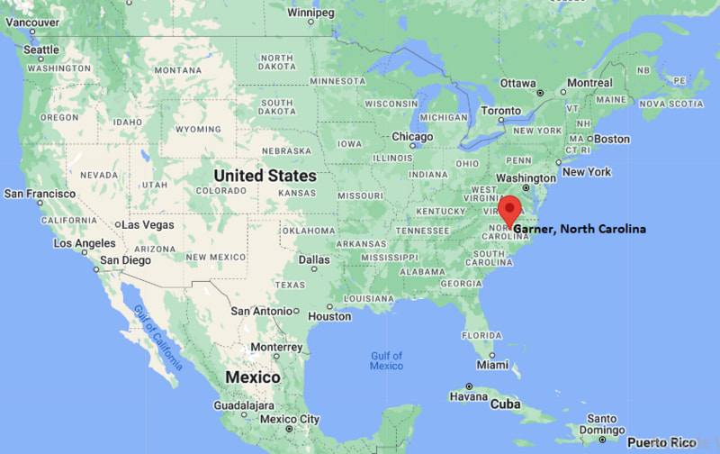
Garner Map, North Carolina, USA
Where is Garner?: The Google Map showing the location of Garner in the U.S. state of North Carolina.
Where is Garner Located?
Garner is a city located in the Wake County of North Carolina, United States. Garner lies between 34.8547756 Degrees North latitudes and 106.7053035 Degrees West longitudes. According to 2020 U.S.census, the population of Garner city is 31159 people and the city has a total area of 15.9 sq mi. The city has numerous parks and recreational facilities.
Most Viewed US Maps
| USA Sttae Map | USA Region Map | USA Road Map |
| USA County Map | Where is USA in World Map? | US ZIP Code Map |
| USA Time Zones Map | US State and Capitals Map | USA Physical Map |
Find 4,400+ U.S. Cities by State - Explore Their Locations and Get Detailed Information
Garner, North Carolina Quick Facts
| Property | Information |
|---|---|
| City | Garner |
| County | Wake County |
| State | North Carolina |
| State Capital | Raleigh |
| US Region | Southern United States |
| Latitude | 35.7113°N |
| Longitude | 78.6142°W |
| Elevation | 315 ft (96 m) |
| Land Area | 17.84 sq mi |
| Water Area | 0.16 sq mi |
| Total Area | 18.00 sq mi |
| Population (latest Census year) | 31,159 (Census 2020) |
| Population Density (per sq mi) | Approximately 1,747 |
| ZIP Codes | 27529, 27597 |
| Area Code | 919, 984 |
| Time Zone Standard | Eastern Standard Time (EST, UTC−5) |
| Time Zone Daylight | Eastern Daylight Time (EDT, UTC−4) |
| Currency | United States Dollar (USD) |
| FIPS Code | 37-26320 |
| Congressional District | North Carolina's 13th Congressional District |
Nearby Cities to Garner, North Carolina
- Raleigh, North Carolina — 6 mi North
- Clayton, North Carolina — 10 mi Southeast
- Knightdale, North Carolina — 11 mi Northeast
- Fuquay-Varina, North Carolina — 15 mi Southwest
- Apex, North Carolina — 19 mi West
- Cary, North Carolina — 14 mi Northwest
- Wendell, North Carolina — 17 mi Northeast
- Zebulon, North Carolina — 24 mi East
- Holly Springs, North Carolina — 18 mi West
- Smithfield, North Carolina — 23 mi Southeast
Driving Distances from Garner, North Carolina
| City | State | Distance (mi) | Approx. Drive Time |
|---|---|---|---|
| Raleigh | North Carolina | 6 | 15 minutes |
| Clayton | North Carolina | 10 | 18 minutes |
| Knightdale | North Carolina | 11 | 18 minutes |
| Cary | North Carolina | 14 | 22 minutes |
| Fuquay-Varina | North Carolina | 15 | 25 minutes |
| Apex | North Carolina | 19 | 30 minutes |
| Wendell | North Carolina | 17 | 28 minutes |
| Smithfield | North Carolina | 23 | 30 minutes |
| Durham | North Carolina | 31 | 40 minutes |
| Chapel Hill | North Carolina | 38 | 45 minutes |
Transportation and Connectivity in Garner, North Carolina
| Transportation | Details |
|---|---|
| Airport Name | Raleigh-Durham International Airport |
| IATA Code | RDU |
| Port | Not Applicable |
| Major Highways | Interstate 40, U.S. Route 70, U.S. Route 401, North Carolina Highway 50 |
| Train/Amtrak Service | Nearest Amtrak station at Raleigh Union Station |
| Local Bus/Transit Service | GoRaleigh and GoTriangle regional transit services |
- Interstate 40 - Major east-west interstate connecting Garner with Raleigh, Durham, Wilmington, and western North Carolina.
- U.S. Route 70 - Primary corridor linking Garner with Raleigh, Clayton, and eastern North Carolina.
- U.S. Route 401 - Connects the town with downtown Raleigh and communities to the south.
- North Carolina Highway 50 - Provides regional access through Wake and Johnston counties.
What are top Places to Visit in Garner, North Carolina
| Landmark Name | Type |
|---|---|
| Lake Benson Park | Park |
| White Deer Park Nature Center | Nature Center |
| Garner Performing Arts Center | Performing Arts Venue |
| Yates Mill County Park | Historic Park |
| Historic Downtown Garner | Historic District |
| Lake Benson Boathouse | Recreation Area |
| Juniper Level Botanic Garden | Botanical Garden |
| Pullen Park | Park |
| North Carolina Museum of Natural Sciences | Museum |
| North Carolina Museum of Art | Museum |
Colleges and Universities in Garner, North Carolina
| Institution Name | Type | Level | Notable For |
|---|---|---|---|
| Wake Technical Community College | Public | Community College | Career and technical education |
| North Carolina State University | Public | University | Engineering and research |
| Shaw University | Private | University | Historically Black university |
| William Peace University | Private | University | Liberal arts education |
| Wake County Public School System | Public | K–12 District | Public education services |
Waterbodies in Garner, North Carolina
Lake Benson, Swift Creek, Walnut Creek, Neuse River, Lake Wheeler, Middle Creek, Little Creek, Crabtree Creek
Golf Courses in Garner, North Carolina
Riverwood Golf Club, Pine Hollow Golf Club, Eagle Ridge Golf Club, Reedy Creek Golf Course, Lonnie Poole Golf Course, Hedingham Golf Club, Raleigh Golf Association
Garner, North Carolina — Key Historical Facts
- Garner was established in the late nineteenth century as a railroad community along the North Carolina Railroad and quickly became an important shipping point for agricultural products.
- The town was incorporated in 1905 and was named after H.C. Garner, a local landowner who contributed property for the railroad depot.
- During the twentieth century, Garner evolved from a rural farming community into a growing residential suburb of nearby Raleigh.
- The expansion of Interstate 40 and other major highways encouraged commercial development and attracted new businesses and residents.
- Today, Garner is one of Wake County's fastest-growing communities, known for its parks, family-friendly neighborhoods, and convenient access to North Carolina's Research Triangle region.
References
North Carolina Maps and Info
- Where is Albemarle
- Where is Apex
- Where is Asheboro
- Where is Asheville
- Where is Belmont
- Where is Boone
- Where is Burlington
- Where is Carrboro
- Where is Cary
- Where is Chapel Hill
- Where is Clayton
- Where is Clemmons
- Where is Concord
- Where is Cornelius
- Where is Davidson
- Where is Eden
- Where is Elizabeth City
- Where is Fuquay-Varina
- Where is Garner
- Where is Gastonia
- Where is Goldsboro
- Where is Graham
- Where is Greenville
- Where is Harrisburg
- Where is Havelock
- Where is Hendersonville
- Where is Hickory
- Where is High Point
- Where is Holly Springs
- Where is Hope Mills
- Where is Huntersville
- Where is Indian Trail
- Where is Kannapolis
- Where is Kernersville
- Where is Kinston
- Where is Knightdale
- Where is Laurinburg
- Where is Leland
- Where is Lenoir
- Where is Lumberton
- Where is Matthews
- Where is Mebane
- Where is Mint Hill
- Where is Monroe
- Where is Mooresville
- Where is Morganton
- Where is Morrisville
- Where is Mount Holly
- Where is Murraysville
- Where is New Bern
- Where is Pinehurst
- Where is Piney Green
- Where is Reidsville
- Where is Roanoke Rapids
- Where is Rocky Mount
- Where is Salisbury
- Where is Sanford
- Where is Shelby
- Where is Southern Pines
- Where is Stallings
- Where is Statesville
- Where is Thomasville
- Where is Wake Forest
- Where is Waxhaw
- Where is Wilmington
- Where is Wilson
- Where is Winston-Salem