
Where is Kannapolis Located? - Kannapolis is a city located in the Cabarrus, Rowan County of North Carolina, United States. Kannapolis lies between 35.0694767 Degrees North latitudes and 108.8484168 Degrees West longitudes.
Location Map of Kannapolis, North Carolina
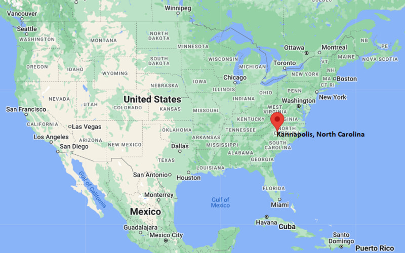
Kannapolis Map, North Carolina, USA
Where is Kannapolis?: The Google Map showing the location of Kannapolis in the U.S. state of North Carolina.
Where is Kannapolis Located?
Kannapolis is a city located in the Cabarrus, Rowan County of North Carolina, United States. Kannapolis lies between 35.0694767 Degrees North latitudes and 108.8484168 Degrees West longitudes. According to 2020 U.S.census, the population of Kannapolis city is 53114 people and the city has a total area of 32.61 sq mi. The city has numerous parks and recreational facilities.
Most Viewed US Maps
| USA Sttae Map | USA Region Map | USA Road Map |
| USA County Map | Where is USA in World Map? | US ZIP Code Map |
| USA Time Zones Map | US State and Capitals Map | USA Physical Map |
Find 4,400+ U.S. Cities by State - Explore Their Locations and Get Detailed Information
Kannapolis, North Carolina Quick Facts
| Property | Details |
|---|---|
| City | Kannapolis |
| County | Cabarrus County and Rowan County |
| State | North Carolina |
| State Capital | Raleigh |
| US Region | South |
| Latitude | 35.4874° N |
| Longitude | 80.6217° W |
| Elevation | 846 ft (258 m) |
| Land Area | 32.30 sq mi |
| Water Area | 0.30 sq mi |
| Total Area | 32.60 sq mi |
| Population (2020 Census) | 53,114 |
| Population Density | About 1,645 per sq mi |
| ZIP Codes | 28081, 28082, 28083 |
| Area Code | 704, 980 |
| Time Zone Standard | Eastern Standard Time (EST, UTC−05:00) |
| Time Zone Daylight | Eastern Daylight Time (EDT, UTC−04:00) |
| Currency | United States Dollar (USD) |
| FIPS Code | 37-35200 |
| Congressional District | 8th Congressional District |
Transportation and Connectivity in Kannapolis
| Category | Details |
|---|---|
| Airport Name | Concord-Padgett Regional Airport (nearest); Charlotte Douglas International Airport (major airport) |
| IATA Code | USA (Concord), CLT (Charlotte) |
| Port | Not Applicable |
| Major Highways | I-85, US 29, NC 3, NC 73 |
| Train/Amtrak Service | Kannapolis Amtrak Station (Carolinian & Piedmont) |
| Local Bus/Transit Service | Kannapolis Rider Transit (KRT) and Concord Kannapolis Area Transit (CK Rider) |
- Interstate 85 provides direct access to Charlotte, Greensboro, and other major cities in North Carolina.
- US Highway 29 serves as an important local and regional transportation corridor.
- North Carolina Highway 3 connects Kannapolis with Mooresville and surrounding communities.
- The Kannapolis Amtrak Station offers daily Carolinian and Piedmont passenger rail service.
- CK Rider and Kannapolis Rider Transit provide public transportation throughout the city and neighboring areas.
Top Places to Visit in Kannapolis, North Carolina
| Landmark Name | Type |
|---|---|
| North Carolina Research Campus | Research & Innovation Center |
| Village Park | City Park |
| Atrium Health Ballpark | Baseball Stadium |
| Dale Earnhardt Tribute Plaza | Monument |
| Gem Theatre | Historic Theater |
| Curb Museum for Music and Motorsports | Museum |
| Kannapolis Recreation Park | Recreation Area |
| Frank Liske Park | Regional Park |
| Vietnam Veterans Park | Memorial Park |
| Downtown Kannapolis | Entertainment District |
Driving Distances from Kannapolis, North Carolina to Nearby Cities
| City | State | Distance (mi) | Approx. Drive Time |
|---|---|---|---|
| Concord | North Carolina | 8 | 15 min |
| Salisbury | North Carolina | 10 | 15 min |
| China Grove | North Carolina | 6 | 10 min |
| Mooresville | North Carolina | 17 | 25 min |
| Huntersville | North Carolina | 22 | 30 min |
| Charlotte | North Carolina | 28 | 35 min |
| Statesville | North Carolina | 35 | 40 min |
| Lexington | North Carolina | 32 | 40 min |
| Albemarle | North Carolina | 34 | 45 min |
| Greensboro | North Carolina | 66 | 1 hr 10 min |
Colleges and Universities in Kannapolis, North Carolina
| Institution Name | Type | Level | Notable For |
|---|---|---|---|
| Rowan-Cabarrus Community College – North Campus | Public | Community College | Technical education, workforce development, and transfer programs |
| Cabarrus College of Health Sciences | Private | College | Healthcare and nursing education |
| University of North Carolina at Charlotte | Public | University | Research university located nearby in Charlotte |
| Livingstone College | Private | College | Historically Black liberal arts college in nearby Salisbury |
| Catawba College | Private | College | Liberal arts and undergraduate education |
Waterbodies in Kannapolis, North Carolina
Kannapolis is situated near several lakes, rivers, and creeks that support recreation and local ecosystems. Prominent waterbodies include Irish Buffalo Creek, Rocky River, Lake Fisher, Lake Concord, Coddle Creek Reservoir, High Rock Lake, Lake Norman, and Mountain Creek.
Golf Courses in Kannapolis
Golf enthusiasts have access to several quality courses in and around Kannapolis, including The Club at Irish Creek, Rocky River Golf Club, Warrior Golf Club, Corbin Hills Golf Club, Mooresville Golf Club, and Skybrook Golf Club.
Kannapolis, North Carolina — Key Historical Facts
- Kannapolis was established in 1906 when textile entrepreneur James William Cannon founded Cannon Mills, which became one of the world's largest towel and textile manufacturers.
- The city grew rapidly as a classic American mill town, with Cannon Mills serving as the primary employer for much of the twentieth century.
- In the late twentieth century, the decline of the textile industry led to significant economic changes and redevelopment efforts.
- The North Carolina Research Campus, opened in 2008, transformed Kannapolis into a nationally recognized center for biotechnology, nutrition, and health research.
- Today, Kannapolis continues to revitalize its downtown while expanding research, education, healthcare, and recreational opportunities.
References
- City of Kannapolis
- U.S. Census Bureau – Kannapolis City QuickFacts
- Rowan-Cabarrus Community College
- North Carolina Research Campus
- Explore Cabarrus
North Carolina Maps and Info
- Where is Albemarle
- Where is Apex
- Where is Asheboro
- Where is Asheville
- Where is Belmont
- Where is Boone
- Where is Burlington
- Where is Carrboro
- Where is Cary
- Where is Chapel Hill
- Where is Clayton
- Where is Clemmons
- Where is Concord
- Where is Cornelius
- Where is Davidson
- Where is Eden
- Where is Elizabeth City
- Where is Fuquay-Varina
- Where is Garner
- Where is Gastonia
- Where is Goldsboro
- Where is Graham
- Where is Greenville
- Where is Harrisburg
- Where is Havelock
- Where is Hendersonville
- Where is Hickory
- Where is High Point
- Where is Holly Springs
- Where is Hope Mills
- Where is Huntersville
- Where is Indian Trail
- Where is Kannapolis
- Where is Kernersville
- Where is Kinston
- Where is Knightdale
- Where is Laurinburg
- Where is Leland
- Where is Lenoir
- Where is Lumberton
- Where is Matthews
- Where is Mebane
- Where is Mint Hill
- Where is Monroe
- Where is Mooresville
- Where is Morganton
- Where is Morrisville
- Where is Mount Holly
- Where is Murraysville
- Where is New Bern
- Where is Pinehurst
- Where is Piney Green
- Where is Reidsville
- Where is Roanoke Rapids
- Where is Rocky Mount
- Where is Salisbury
- Where is Sanford
- Where is Shelby
- Where is Southern Pines
- Where is Stallings
- Where is Statesville
- Where is Thomasville
- Where is Wake Forest
- Where is Waxhaw
- Where is Wilmington
- Where is Wilson
- Where is Winston-Salem