
Where is Belle Fourche Located? - Belle Fourche is a city located in the Butte County of South Dakota, United States. Belle Fourche lies between 44.67228 Degrees North latitudes and -103.84 Degrees West longitudes.
Location Map of Belle Fourche, South Dakota
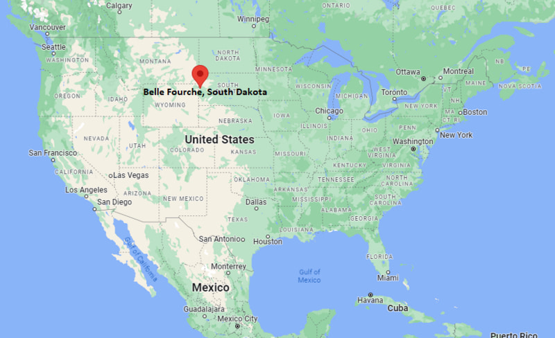
Belle Fourche Map, South Dakota, USA
Where is Belle Fourche?: The Google Map showing the location of Belle Fourche in the U.S. state of South Dakota.
Where is Belle Fourche Located?
Belle Fourche is a city located in the Butte County of South Dakota, United States. Belle Fourche lies at approximately 44.67228 Degrees North latitude and -103.84 Degrees West longitude. According to the 2020 U.S. Census, the population of Belle Fourche city is 5,617 people and the city has a total area of 8.928 sq mi. The city has numerous parks and recreational facilities.
Most Viewed US Maps
| USA Sttae Map | USA Region Map | USA Road Map |
| USA County Map | Where is USA in World Map? | US ZIP Code Map |
| USA Time Zones Map | US State and Capitals Map | USA Physical Map |
Find 4,400+ U.S. Cities by State - Explore Their Locations and Get Detailed Information
Belle Fourche, South Dakota Quick Facts
| Fact | Details |
|---|---|
| City | Belle Fourche |
| County | Butte County |
| State | South Dakota |
| State Capital | Pierre |
| Country | United States |
| US Region | Midwest |
| Latitude | 44.67228 N |
| Longitude | -103.84 W |
| Elevation | 3,022 ft (921 m) |
| Land Area | 8.5 sq mi |
| Water Area | 0.1 sq mi |
| Total Area | 8.928 sq mi |
| Population (Census 2020) | 5,617 |
| Population Density | Approximately 661 per sq mi |
| ZIP Codes | 57717 |
| Area Code | 605 |
| Time Zone Standard | Mountain Standard Time (MST, UTC-7) |
| Time Zone Daylight | Mountain Daylight Time (MDT, UTC-6) |
| Currency | United States Dollar (USD) |
| FIPS Code | 46-04660 |
| Congressional District | South Dakota At-Large Congressional District |
Nearby Cities to Belle Fourche, South Dakota
- Spearfish, South Dakota - 12 mi Southeast
- Sturgis, South Dakota - 27 mi Southeast
- Deadwood, South Dakota - 28 mi South
- Lead, South Dakota - 31 mi South
- Sundance, Wyoming - 31 mi West
- Whitewood, South Dakota - 24 mi Southeast
- Newell, South Dakota - 32 mi East
- Rapid City, South Dakota - 58 mi Southeast
- Gillette, Wyoming - 72 mi West
- Hulett, Wyoming - 52 mi West
Belle Fourche, South Dakota Climate and Weather Overview
| Month | Avg High (°F) | Avg Low (°F) | Avg Rainfall (in) |
|---|---|---|---|
| January | 36 | 14 | 0.4 |
| April | 58 | 31 | 1.6 |
| July | 87 | 58 | 2.0 |
| October | 62 | 35 | 1.1 |
| Annual | 61 | 35 | 15.8 |
| Climate Attribute | Details |
|---|---|
| Climate Classification | Cold Semi-Arid (Köppen BSk) |
| Annual Rainfall | Approximately 16 inches |
| Annual Sunshine Days | About 226 days |
| Hurricane/Tornado Risk | Low - Occasional severe thunderstorms and hail |
| Snowfall | Approximately 37 inches annually |
Driving Distances from Belle Fourche, South Dakota
| City | State | Distance (mi) | Approx. Drive Time |
|---|---|---|---|
| Spearfish | South Dakota | 12 | 15 min |
| Whitewood | South Dakota | 24 | 25 min |
| Sturgis | South Dakota | 27 | 30 min |
| Deadwood | South Dakota | 28 | 35 min |
| Lead | South Dakota | 31 | 40 min |
| Sundance | Wyoming | 31 | 35 min |
| Newell | South Dakota | 32 | 35 min |
| Hulett | Wyoming | 52 | 1 hr |
| Rapid City | South Dakota | 58 | 1 hr |
| Gillette | Wyoming | 72 | 1 hr 15 min |
Transportation and Connectivity in Belle Fourche, South Dakota
| Transportation | Details |
|---|---|
| Airport Name | Black Hills Airport (Spearfish) |
| IATA Code | SPF |
| Port | Not Applicable |
| Major Highways | U.S. Highway 85, U.S. Highway 212, South Dakota Highway 34 |
| Train/Amtrak Service | No passenger rail service; nearest Amtrak station at Havre, Montana |
| Local Bus/Transit Service | Regional demand-response transit and Black Hills transportation services |
- U.S. Highway 85 - Major north-south highway connecting Belle Fourche with Wyoming, North Dakota and the Black Hills.
- U.S. Highway 212 - Runs east-west through the city, linking northeastern Wyoming with northern South Dakota and Minnesota.
- South Dakota Highway 34 - Connects Belle Fourche with Sturgis, Pierre and central South Dakota.
- State and county roads - Provide access to surrounding ranches, recreational areas and communities across Butte County and the northern Black Hills.
Belle Fourche, South Dakota - Key Landmarks and Places to Visit
| Landmark | Type |
|---|---|
| Center of the Nation Monument | Monument |
| Tri-State Museum | Museum |
| Belle Fourche River Walk | Walking Trail |
| Hermann Park | City Park |
| Black Hills Roundup Grounds | Event Venue |
| Center of the Nation Visitor Center | Visitor Center |
| Charles and Eleanor Newell House Museum | Historic House |
| Orman Dam Recreation Area | Recreation Area |
| Devils Tower National Monument | National Monument |
| Spearfish Canyon Scenic Byway | Scenic Drive |
Colleges and Universities in Belle Fourche, South Dakota
| Institution | Type | Level | Notable For |
|---|---|---|---|
| Black Hills State University | Public | University | Education and business programs |
| Western Dakota Technical College | Public | Technical College | Career and skilled trades |
| South Dakota School of Mines & Technology | Public | University | Engineering and science |
| National American University - Rapid City | Private | University | Business and healthcare |
| Oglala Lakota College | Tribal Public | College | Native American education |
| Gillette College | Public | Community College | Transfer and workforce education |
Waterbodies in Belle Fourche, South Dakota
Belle Fourche River, Redwater River, Owl Creek, Horse Creek, Hay Creek, Orman Reservoir, Belle Fourche Reservoir, Bear Butte Lake, Cheyenne River, Pactola Reservoir.
Golf Courses in Belle Fourche, South Dakota
Belle Fourche Country Club, Spearfish Canyon Country Club, Elkhorn Ridge Golf Club, Boulder Canyon Golf Club, Lead Country Club, Hart Ranch Golf Club, Red Rock Golf Club, Arrowhead Country Club.
Belle Fourche, South Dakota - Key Historical Facts
- Belle Fourche was founded in 1883 as a railroad town and quickly became a major shipping center for livestock and wool in the northern Black Hills region.
- The city's name comes from the nearby Belle Fourche River, whose French name means "beautiful fork."
- During the late nineteenth century, Belle Fourche was one of the world's largest livestock shipping points.
- The annual Black Hills Roundup, first held in 1919, remains one of South Dakota's oldest and most celebrated rodeos.
- The city is recognized as the geographic Center of the Nation because it lies near the geographic center of the fifty United States.
- Today, Belle Fourche serves as a regional center for agriculture, tourism and outdoor recreation while preserving its western heritage.
References
More South Dakota Maps & Info
- Where is Aberdeen
- Where is Belle Fourche
- Where is Beresford
- Where is Blackhawk
- Where is Box Elder
- Where is Brandon
- Where is Brookings
- Where is Canton
- Where is Chamberlain
- Where is Colonial Pine Hills
- Where is Crooks
- Where is Custer
- Where is Dell Rapids
- Where is Elk Point
- Where is Flandreau
- Where is Fort Pierre
- Where is Harrisburg
- Where is Hartford
- Where is Hot Springs
- Where is Huron
- Where is Lead
- Where is Lennox
- Where is Milbank
- Where is Mitchell
- Where is Mobridge
- Where is North Eagle Butte
- Where is North Sioux City
- Where is North Spearfish
- Where is Parkston
- Where is Pierre
- Where is Pine Ridge
- Where is Rapid City
- Where is Rapid Valley
- Where is Redfield
- Where is Rosebud
- Where is Sioux Falls
- Where is Sisseton
- Where is Spearfish
- Where is Sturgis
- Where is Summerset
- Where is Tea
- Where is Vermillion
- Where is Volga
- Where is Wagner
- Where is Watertown
- Where is Webster
- Where is Winner
- Where is Yankton