
Where is Volga Located? - Volga is a city located in the Brookings County of South Dakota, United States. Volga lies between 42.2068123 Degrees North latitudes and 121.737224 Degrees West longitudes.
Location Map of Volga, South Dakota
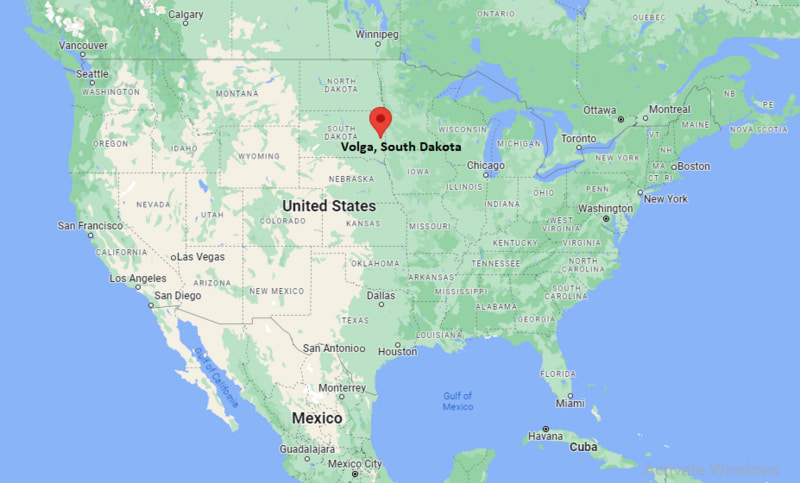
Volga Map, South Dakota, USA
Where is Volga?: The Google Map showing the location of Volga in the U.S. state of South Dakota.
Where is Volga Located?
Volga is a city located in the Brookings County of South Dakota, United States. Volga lies between 42.2068123 Degrees North latitudes and 121.737224 Degrees West longitudes. According to 2020 U.S.census, the population of Volga city is 2113 people and the city has a total area of 0.95 sq mi. The city has numerous parks and recreational facilities.
Most Viewed US Maps
| USA Sttae Map | USA Region Map | USA Road Map |
| USA County Map | Where is USA in World Map? | US ZIP Code Map |
| USA Time Zones Map | US State and Capitals Map | USA Physical Map |
Find 4,400+ U.S. Cities by State - Explore Their Locations and Get Detailed Information
Volga, South Dakota Quick Facts
| Attribute | Details |
|---|---|
| City | Volga |
| County | Brookings County |
| State | South Dakota |
| State Capital | Pierre |
| US Region | Midwestern United States |
| Latitude | 44.3211° N |
| Longitude | 96.9267° W |
| Elevation | Approximately 1,640 ft (500 m) |
| Land Area | 1.1 sq mi |
| Water Area | 0.0 sq mi |
| Total Area | 1.1 sq mi |
| Population (2020 Census) | 2,273 |
| Population Density | Approximately 2,070 per sq mi |
| ZIP Code | 57071 |
| Area Code | 605 |
| Time Zone Standard | Central Standard Time (CST), UTC−6 |
| Time Zone Daylight | Central Daylight Time (CDT), UTC−5 |
| Currency | United States Dollar (USD) |
| FIPS Code | 46-68380 |
| Community Type | City |
Transportation and Connectivity in Volga, South Dakota
| Transportation | Details |
|---|---|
| Airport Name | Brookings Regional Airport |
| IATA Code | BRO |
| Regional Airport | Sioux Falls Regional Airport |
| Port | Not applicable (inland city) |
| Major Highways | US Route 14, Interstate 29, South Dakota Highway 13 |
| Train/Amtrak Service | Amtrak service available in nearby communities |
| Local Transit Service | Brookings Area Transit services |
- Interstate 29 — Major north-south interstate connecting Volga with Sioux Falls, Brookings, and North Dakota communities.
- US Route 14 — Regional highway connecting eastern South Dakota communities.
- South Dakota Highway 13 — Provides local access through Brookings County.
Top Places to Visit Near Volga, South Dakota
| Landmark Name | Type |
|---|---|
| McCrory Gardens | Botanical Garden |
| South Dakota Art Museum | Art Museum |
| Brookings County Museum | History Museum |
| Children's Museum of South Dakota | Children's Museum |
| Oakwood Lakes State Park | State Park |
| Swiftel Center | Event Venue |
| South Dakota State University Campus | Educational Landmark |
| Lake Campbell | Recreation Area |
| Big Sioux River | Natural Landmark |
| Brookings City Park | Community Park |
Driving Distances from Volga, South Dakota to Nearby Cities
| City | State | Distance (mi) | Approx. Drive Time |
|---|---|---|---|
| Brookings | South Dakota | 5 mi | 10 minutes |
| Sioux Falls | South Dakota | 60 mi | 1 hour |
| Watertown | South Dakota | 75 mi | 1 hour 15 minutes |
| Mitchell | South Dakota | 125 mi | 2 hours |
| Yankton | South Dakota | 150 mi | 2 hours 30 minutes |
| Pierre | South Dakota | 190 mi | 3 hours |
| Rapid City | South Dakota | 380 mi | 5 hours 45 minutes |
| Omaha | Nebraska | 220 mi | 3 hours 30 minutes |
| Minneapolis | Minnesota | 220 mi | 3 hours 30 minutes |
| Des Moines | Iowa | 260 mi | 4 hours |
Colleges and Universities Near Volga, South Dakota
| Institution Name | Type | Level | Notable For |
|---|---|---|---|
| South Dakota State University | Public | University | Agriculture, engineering, nursing, pharmacy, education, and research programs |
| Lake Area Technical College | Public | Technical College | Career training, technology, and workforce programs |
| Southeast Technical College | Public | Technical College | Applied technology, health sciences, and career education |
| University of South Dakota | Public | University | Law, business, health sciences, and liberal arts programs |
| Brookings School District | Public | K–12 District | Local public education |
Waterbodies Near Volga, South Dakota
Big Sioux River, Lake Campbell, Oakwood Lakes, Lake Tetonkaha, and nearby Brookings County waterways
Golf Courses and Stadiums Near Volga
Golf Courses: Edgebrook Golf Course, Brookings Country Club, and nearby eastern South Dakota golf facilities. Stadiums: Dana J. Dykhouse Stadium at South Dakota State University, Frost Arena, and local community sports facilities.
Key Landmarks and Places to Visit Near Volga, South Dakota
| Landmark Name | Type |
|---|---|
| South Dakota State University | Educational Landmark |
| McCrory Gardens | Botanical Garden |
| South Dakota Art Museum | Art Museum |
| Children's Museum of South Dakota | Children's Museum |
| Brookings County Museum | History Museum |
| Oakwood Lakes State Park | State Park |
| Swiftel Center | Event Venue |
| Big Sioux River | Natural Landmark |
| Lake Campbell | Recreation Area |
| Brookings Historic Downtown | Historic District |
Volga, South Dakota — Key Historical Facts
- The Volga area was originally inhabited by Native American groups of the Great Plains region, including the Dakota people.
- Volga was settled in the late 19th century as European immigrants moved into eastern South Dakota during agricultural expansion.
- The city was named after the Volga River region of Russia, reflecting the heritage of some early settlers.
- The arrival of the railroad helped Volga develop as an agricultural shipping and service community.
- Agriculture has remained an important part of the local economy, with farming and livestock production surrounding the city.
- Today, Volga is a small community located near Brookings and South Dakota State University, offering access to education, recreation, and rural South Dakota living.
References
- United States Census Bureau
- City of Volga Official Website
- Brookings County Official Website
- State of South Dakota Official Website
- South Dakota Tourism
More South Dakota Maps & Info
- Where is Aberdeen
- Where is Belle Fourche
- Where is Beresford
- Where is Blackhawk
- Where is Box Elder
- Where is Brandon
- Where is Brookings
- Where is Canton
- Where is Chamberlain
- Where is Colonial Pine Hills
- Where is Crooks
- Where is Custer
- Where is Dell Rapids
- Where is Elk Point
- Where is Flandreau
- Where is Fort Pierre
- Where is Harrisburg
- Where is Hartford
- Where is Hot Springs
- Where is Huron
- Where is Lead
- Where is Lennox
- Where is Milbank
- Where is Mitchell
- Where is Mobridge
- Where is North Eagle Butte
- Where is North Sioux City
- Where is North Spearfish
- Where is Parkston
- Where is Pierre
- Where is Pine Ridge
- Where is Rapid City
- Where is Rapid Valley
- Where is Redfield
- Where is Rosebud
- Where is Sioux Falls
- Where is Sisseton
- Where is Spearfish
- Where is Sturgis
- Where is Summerset
- Where is Tea
- Where is Vermillion
- Where is Volga
- Where is Wagner
- Where is Watertown
- Where is Webster
- Where is Winner
- Where is Yankton